MyTopo
Parsons Tennessee US Topo Map
Couldn't load pickup availability
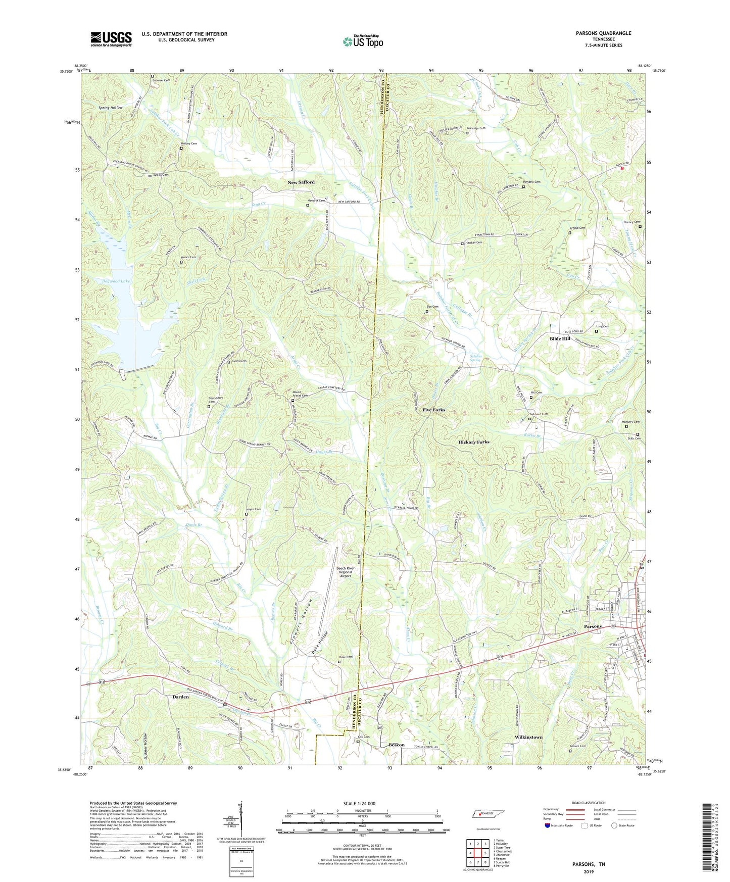
2022 topographic map quadrangle Parsons in the state of Tennessee. Scale: 1:24000. Based on the newly updated USGS 7.5' US Topo map series, this map is in the following counties: Henderson, Decatur. The map contains contour data, water features, and other items you are used to seeing on USGS maps, but also has updated roads and other features. This is the next generation of topographic maps. Printed on high-quality waterproof paper with UV fade-resistant inks.
Quads adjacent to this one:
West: Chesterfield
Northwest: Yuma
North: Holladay
Northeast: Sugar Tree
East: Jeannette
Southeast: Perryville
South: Scotts Hill
Southwest: Reagan
This map covers the same area as the classic USGS quad with code o35088f2.
Contains the following named places: Arnold Cemetery, Beacon, Beacon Baptist Church, Beacon Church of Christ, Beacon Cumberland Presbyterian Church, Beacon Junction, Beacon School, Bear Creek, Bear Creek Baptist Church, Beech River Regional Airport, Bible Hill, Bible Hill Baptist Church, Bible Hill Church, Bible Hill School, Big Branch, Blankenship, Box Cemetery, Bradfield Branch, Brown Spring Branch, Buckner Branch, Cagle Branch, Carrington Branch, Cedar Hill Church, Center Hill Church of Christ, Central School, Cheney Cemetery, Colwick Branch, Commissioner District 6, Corinth Chapel, Corinth School, Cox Cemetery, Darden, Darden Baptist Church, Darden Census Designated Place, Darden Post Office, Darden School, Davis Branch, Derryberry Cemetery, Dodd Branch, Dogwood Dam, Dogwood Lake, Duke Cemetery, Duke Chapel, Duke Hollow, Duke School, Eubanks Cemetery, Evans Branch, Evans Cemetery, Five Forks, Flowers Hollow, Gabbard Cemetery, Gilbert Branch, Glenwood School, Graves Cemetery, Greasy Creek, Gulledge Branch, Gulledge Cemetery, Hawkes Branch, Hawkes Cemetery, Hayes Branch, Hayes Cemetery, Hendrix Cemetery, Hendrix Chapel, Hickory Forks, Hill Cemetery, Howard Branch, Hydro Volunteer Fire Department, King Creek, Lexington Management Corporation Dam, Lexington Management Corporation Lake, Long Cemetery, Mackey Branch, Mays School, McCoy Branch, McCoy Cemetery, McMurry Cemetery, Midway School, Milton Branch, Mincey Cemetery, Moore Cemetery, Moores Hill School, Mount Ararat Cemetery, Mount Ararat Church, New Safford, Old Safford, Parsons, Parsons College, Parsons Elementary School, Parsons Fire Department, Parsons First Baptist Church, Parsons High School, Parsons Junior High School, Parsons Post Office, Parsons United Methodist Church, Pleasant Grove Church, Pleasant Hill Church, Pleasant Hill School, Reeves Branch, Refish Number One Dam, Refish Number One Lake, Refish Number Two Dam, Refish Number Two Lake, Roberts Branch, Rocky Branch, Rushing Branch, Scott Field, Shell Fork, Shipman Creek, Spring Hollow, Stills Cemetery, Sulphur Spring, Sulphur Spring Church, Sulphur Springs, Tomlins Chapel Baptist Church, Tub Store, Tubbs Spring Branch, West Fork Cub Creek, Wilkinstown, Wilson Branch, WTBP-AM (Parsons), ZIP Code: 38328