
MyTopo
Rankin Tennessee US Topo Map
Couldn't load pickup availability
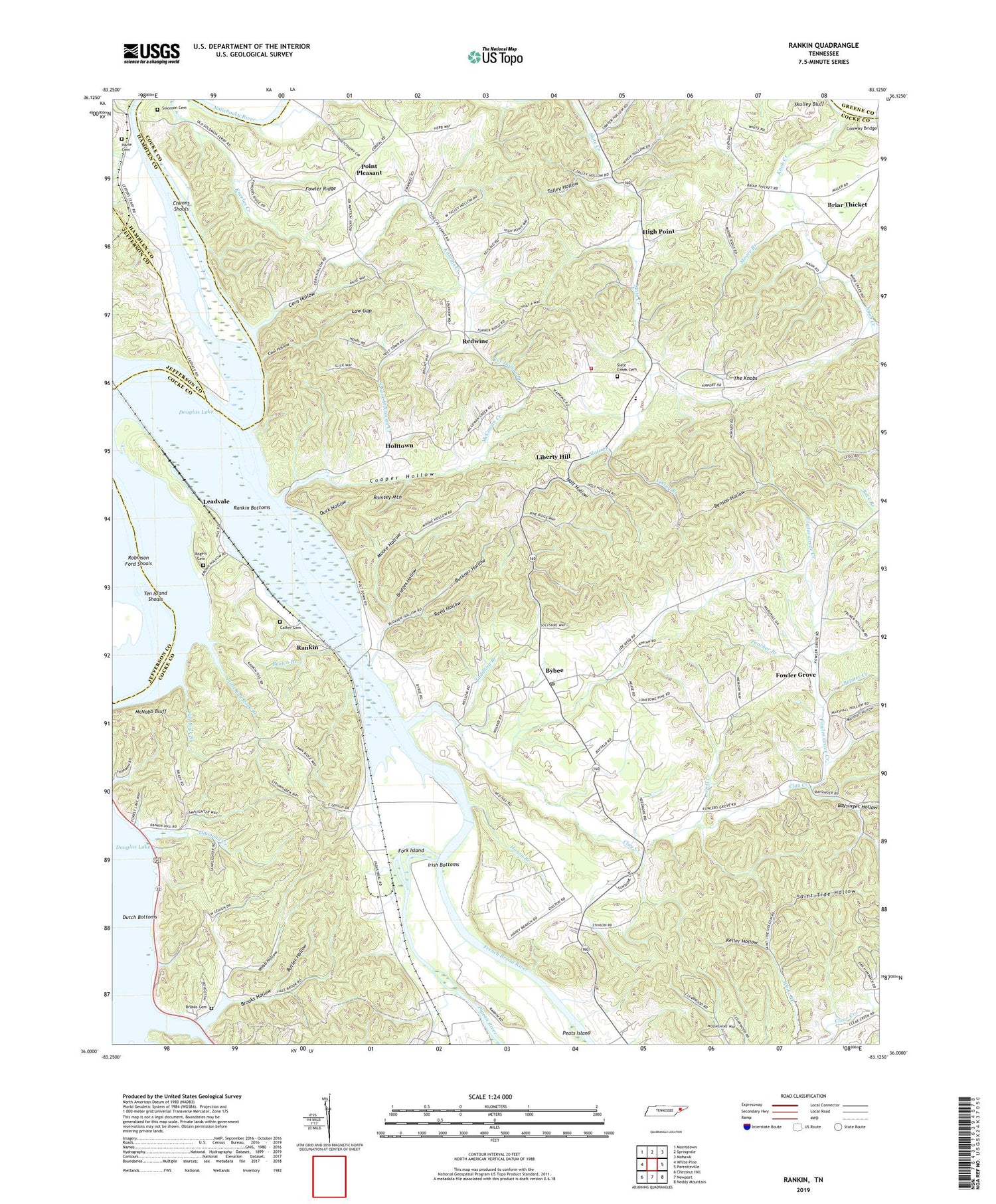
2019 topographic map quadrangle Rankin in the state of Tennessee. Scale: 1:24000. Based on the newly updated USGS 7.5' US Topo map series, this map is in the following counties: Cocke, Hamblen, Jefferson, Greene. The map contains contour data, water features, and other items you are used to seeing on USGS maps, but also has updated roads and other features. This is the next generation of topographic maps. Printed on high-quality waterproof paper with UV fade-resistant inks.
Quads adjacent to this one:
West: White Pine
Northwest: Morristown
North: Springvale
Northeast: Mohawk
East: Parrottsville
Southeast: Neddy Mountain
South: Newport
Southwest: Chestnut Hill
Contains the following named places: Allen Creek, Atchleys Mill, Baysinger Hollow, Benson Hollow, Briar Thicket, Briar Thicket Church, Bridges Hollow, Brooks Cemetery, Brooks Hollow, Brown Branch, Brown Hollow, Buckner Hollow, Butler Hollow, Bybee, Bybee Post Office, Bybee School, Bybee United Methodist Church, Calfee Cemetery, Centerview Church, Centerview Division, Centerview Elementary School, Centerview Volunteer Fire Department, Chunns Shoals, Clay Creek, Clay Creek Church, Cocke County Ambulance Service, Commissioner District 3, Conway Bridge, Cool Hollow, Cooper Hollow, Corn Hollow, Deep Ford Bridge, Diamond Creek, Douglas Shores Campground, Duck Hollow, Fairfax Farm, Fall Rock Branch, Fancher Branch, Fork Island, Fowler Grove, Fowler Grove Creek, Fowler Grove School, Fowler Ridge, Fowlers Grove Church, Fox Hollow Branch, Grandview School, Green Meadows School, Haney Branch, Harle Cemetery, Harle Island, High Point, High Point School, Holt Hollow, Holt School, Holts Community School, Holttown, Irish Bottoms, Jones Clark Island, Joseph Chapel, Keller Hollow, Knob Creek, Leadvale, Liberty Hill, Liberty Hill Baptist Church, Lilac, Little Fall Rock Branch, Lovell Creek, Low Gap, Marshall Hollow, McCowan Creek, McCowan Creek Church, McNabb Bluff, McNabb School, Moore Branch, Moore Hollow, Morgan Island, Morris Island, New Bethel Church, New Home Church, Nolichucky River, North Fork McCowan Creek, Palmer Creek, Peats Island, Pigeon River, Pleasant Point Baptist Church, Point Pleasant, Ramsey Mountain, Rankin, Rankin Bottoms, Rankin School, Rays Chapel, Redwine, Reed Hollow, Robinson Ford, Robinson Ford Shoals, Rogers Cemetery, Rorex Chapel, Saint Tide Church, Saint Tide Hollow, Sawyer Hollow, Six Forks Church, Slate Creek Cemetery, Solomon Cemetery, Solomon Ferry, Stokelys Island, Taddling Branch, Talley Hollow, Talley Memorial School, Ten Island Shoals, Ten Islands, Union Church, Unity School, Vinson Branch, Webb Hollow, White Branch, ZIP Code: 37713


