MyTopo
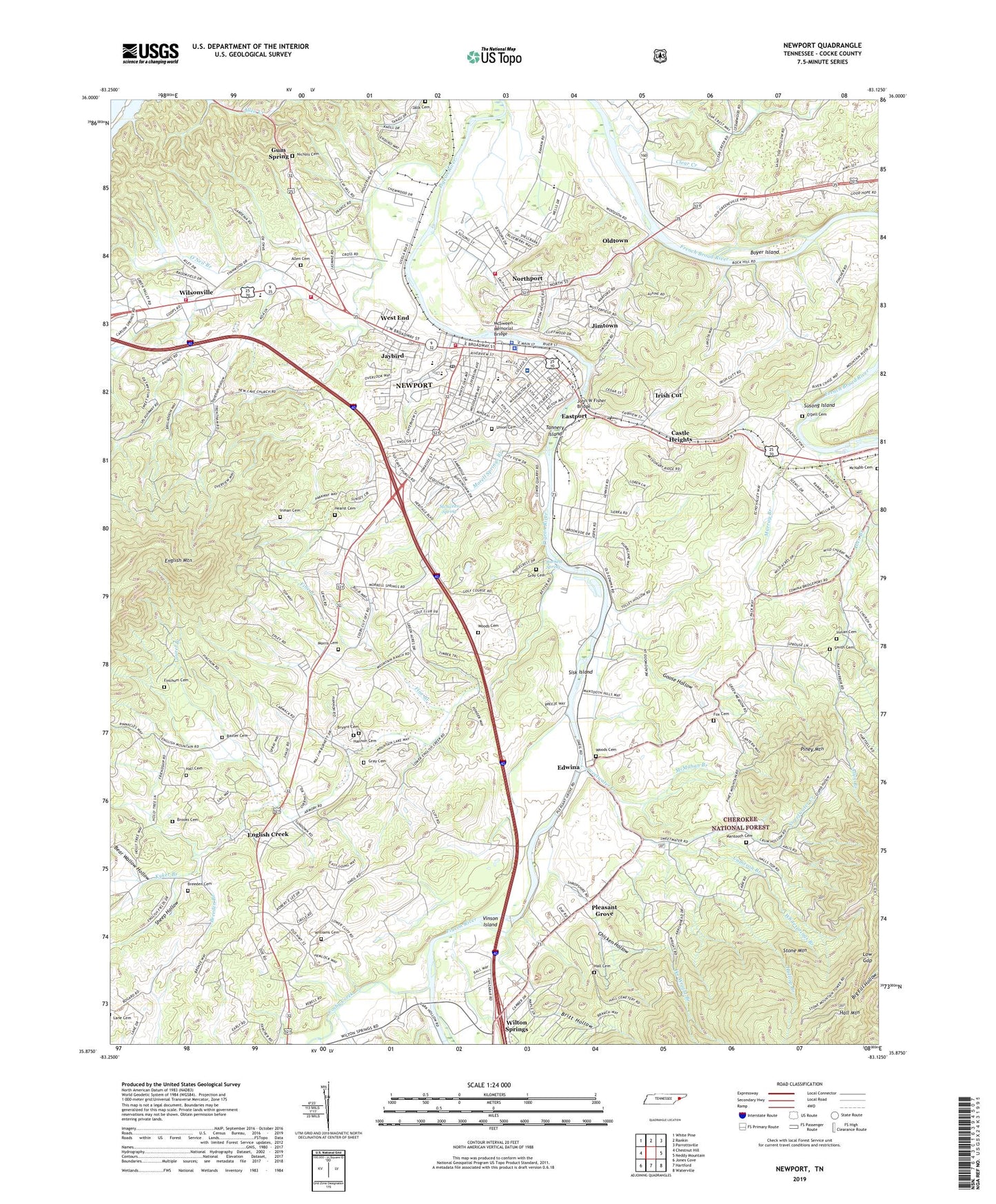
Newport Tennessee US Topo Map
Couldn't load pickup availability
Also explore the Newport Forest Service Topo of this same quad for updated USFS data
2022 topographic map quadrangle Newport in the state of Tennessee. Scale: 1:24000. Based on the newly updated USGS 7.5' US Topo map series, this map is in the following counties: Cocke. The map contains contour data, water features, and other items you are used to seeing on USGS maps, but also has updated roads and other features. This is the next generation of topographic maps. Printed on high-quality waterproof paper with UV fade-resistant inks.
Quads adjacent to this one:
West: Chestnut Hill
Northwest: White Pine
North: Rankin
Northeast: Parrottsville
East: Neddy Mountain
Southeast: Waterville
South: Hartford
Southwest: Jones Cove
This map covers the same area as the classic USGS quad with code o35083h2.
Contains the following named places: Alexander School, Allen Branch, Allen Cemetery, Bat Harbor, Bat Harbor Church, Baxter Cemetery, Bear Wallow Hollow, Big Pigeon Church, Boyer Island, Breeden Branch, Breeden Cemetery, Britt Hollow, Brooks Cemetery, Bryant Cemetery, Burnett Spring, Calvary Church, Cameron Branch, Castle Heights, Cave Hill Church, Cave School, Center View Church, Chicken Hollow, City of Newport, Clear Creek, Cocke County Courthouse, Cocke County Farm, Cocke County Fire Department, Cocke County High School, Cocke County Sheriff's Department, Cocke County Vocational School, Coldspring Branch, Commissioner District 6, Commissioner District 7, Cosby Creek, Crawley Pond, Crumb Hollow, Eastport, Edwina, Edwina School, English Creek, English Creek Baptist Church, English Creek School, Ezekiel Fox Cemetery, Fair Ground School, Finchum Cemetery, Fine Branch, Fines Ferry, First Call Ambulance Services, Goose Hollow, Gospel Tabernacle, Gray Cemetery, Gregg Chapel, Gum Spring, Hall Cemetery, Halltop Branch, Hannon Cemetery, Hearst Cemetery, Ike Wright Branch, Inman Cemetery, Irish Cut, Irish Cut School, Jack Cemetery, Jaybird, Jimtown, John W Fisher Bridge, Kyker Branch, Laurel Branch, Lincoln Avenue Baptist Church, Lindsey Church, Little Pigeon Church, Low Gap, Lowes Chapel, Magnum EMS, Mantooth Cemetery, McMahan Branch, McNabb Cemetery, McSween Memorial Bridge, McSween Spring, Morell Springs Branch, Morris Cemetery, Mount Bethel Church, Mount Zion Church, Mountain View School, Murray Branch, New Testament Church, Newport, Newport Division, Newport Fire Department, Newport Fire Department Station 2, Newport First Baptist Church, Newport Junction, Newport Police Department, Newport Post Office, Newport Rescue Squad, Nichols Cemetery, Nichols Chapel, Northport, Northport Baptist Church, Northport School, Northwest Elementary School, O'Dell Cemetery, O'Dell School, Oldtown, Oldtown School, O'Neil Branch, Pheasant Branch, Piney Mountain, Piney Mountain Mission Union Church, Pleasant Grove, Pleasant Grove Baptist Church, Rice Church, Rock Hill School, Rosenwald School, Russell Chapel, Shady Grove Church, Sheep Hollow, Sinking Creek, Sisk Island, Smith Cemetery, Smith Quarry, Smoky Mountain Golf Course, Southside Baptist Church, Stokely Chapel, Susong Island, Sweetwater Creek, Tanner School, Tannery Island, Tannery School, Tennova Healthcare Newport Medical Center, Trantham Hollow, Union Cemetery, Vinson Island, West End, West End Baptist Church, West End Church, West End School, Whitesprings Branch, Williams Cemetery, Wilsonville, Wilton Springs, WLIK-AM (Newport), WNPC-AM (Newport), Woods Cemetery, Yellow Springs Branch, ZIP Code: 37821