MyTopo
Neddy Mountain Tennessee US Topo Map
Couldn't load pickup availability
Also explore the Neddy Mountain Forest Service Topo of this same quad for updated USFS data
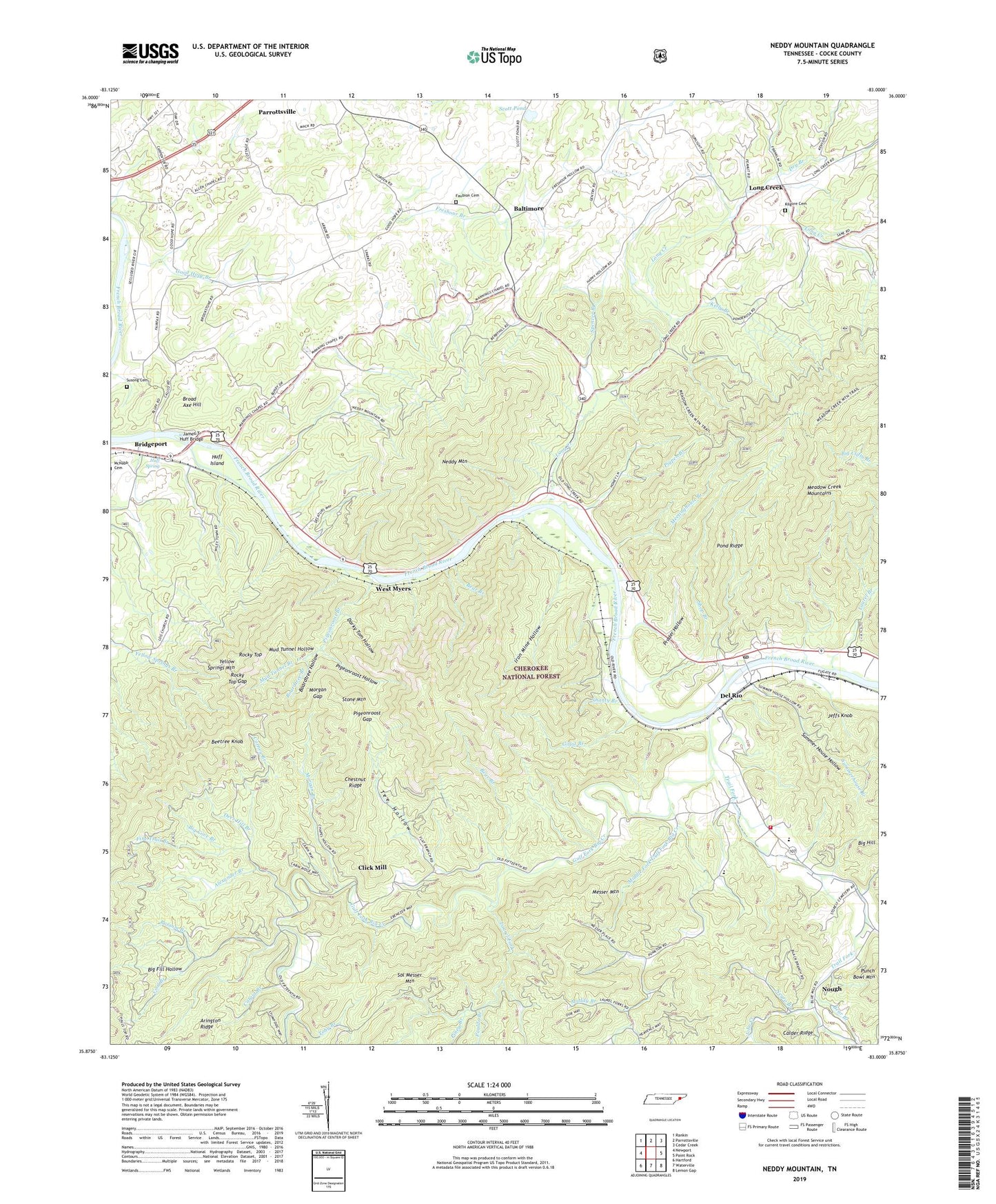
2022 topographic map quadrangle Neddy Mountain in the state of Tennessee. Scale: 1:24000. Based on the newly updated USGS 7.5' US Topo map series, this map is in the following counties: Cocke. The map contains contour data, water features, and other items you are used to seeing on USGS maps, but also has updated roads and other features. This is the next generation of topographic maps. Printed on high-quality waterproof paper with UV fade-resistant inks.
Quads adjacent to this one:
West: Newport
Northwest: Rankin
North: Parrottsville
Northeast: Cedar Creek
East: Paint Rock
Southeast: Lemon Gap
South: Waterville
Southwest: Hartford
This map covers the same area as the classic USGS quad with code o35083h1.
Contains the following named places: Adams Mine, Alexander Branch, Allen Chapel, Allen Chapel School, Arington Ridge, Baltimore, Bear Branch, Beetree Knob, Beetree Knob Prospect, Bethel Baptist Church, Big Cove Branch, Big Fill Hollow, Blanchard Mine, Boardtree Branch, Boardtree Hollow, Bridgeport, Bridgeport Elementary School, Broad Axe Hill, Bug Branch, Carney Branch, Catgut Branch, Chestnut Ridge, Click Mill, Cocke County, Commissioner District 2, Cool Branch, Darky Tom Branch, Darky Tom Hollow, Darky Tom Mine, Davis School, Deer Hill Branch, Del Rio, Del Rio Baptist Church, Del Rio Division, Del Rio Elementary School, Del Rio Post Office, Del Rio Volunteer Fire Department, Dickey Mine, Dry Branch, Dry Fork, East Meyer, East Meyer Mine, Ebenezer Church, Faubion Cemetery, Fine Trail Branch, Flat Branch, Forest Hill, Forest Hill Church, Forest Hill School, French Broad Church, Freshour Branch, Frog Pond Church, Gillot Branch, Good Hope Branch, Goose Branch, Gulf Fork Big Creek, Huff Island, Huff Prospect, Huff Spring, Iron Mine Hollow, James T Huff Bridge, Jeffs Knob, John Creek, Kelly Branch, Kilgore Cemetery, Laurel Branch, Laurel Fork, Long Creek, Long Creek Church, Long Creek Mill, Long Creek School, Manning Chapel School, Mannings Chapel Baptist Church, Maple Grove Church, Meadow Creek Mountains, Meetinghouse Branch, Messer Mountain, Middle Fork Gulf Fork Big Creek, Middle Fork School, Morgan Branch, Morgan Gap, Mount Zion Church, Mud Tunnel Branch, Mud Tunnel Hollow, Mud Tunnel Hollow Mine, Muddy Branch, Neddy Mountain, Negro Branch, Nough, Oliver Mine, Parrottsville Division, Pauldo Branch, Pigeonroost Branch, Pigeonroost Gap, Pigeonroost Hollow, Pigpen Branch, Piney Branch, Pond Ridge, Possum Branch, Prader Hollow, Read Hill, Reid Hill School, Rocky Top, Rocky Top Gap, Rowe School, Scott Pond, Shanty Branch, Shop Branch, Spence Mine, Spencer Branch, Stone Mine, Summer House Hollow, Summerhouse Branch, Susong Cemetery, Tee Hollow, Toby Branch, Tom Creek, Trail Fork, West Meyer Mine, West Myers, White Rock Hollow, White Rock Hollow Mine, Yellow Spring Branch, Yellow Springs Mountain, ZIP Code: 37727