MyTopo
Sewanee Tennessee US Topo Map
Couldn't load pickup availability
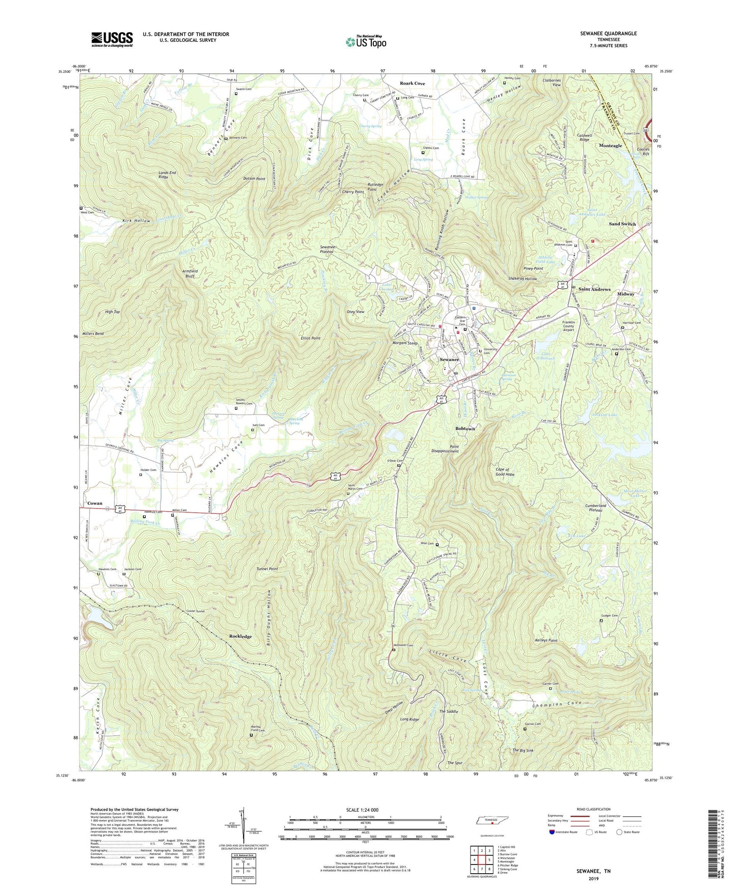
2022 topographic map quadrangle Sewanee in the state of Tennessee. Scale: 1:24000. Based on the newly updated USGS 7.5' US Topo map series, this map is in the following counties: Franklin, Grundy. The map contains contour data, water features, and other items you are used to seeing on USGS maps, but also has updated roads and other features. This is the next generation of topographic maps. Printed on high-quality waterproof paper with UV fade-resistant inks.
Quads adjacent to this one:
West: Winchester
Northwest: Capitol Hill
North: Alto
Northeast: Burrow Cove
East: Monteagle
Southeast: Orme
South: Sinking Cove
Southwest: Pitcher Ridge
This map covers the same area as the classic USGS quad with code o35085b8.
Contains the following named places: Anderson Cemetery, Armfield Bluff, Arnett Mine, Athletic Field Dam, Athletic Field Lake, Barnes Branch, Bennett Cemetery, Bennett Cove, Big Branch, Big Spring, Billy Ought Hollow, Bobtown, Caldwell Ridge, Cape of Good Hope, Cascade Falls, Cedar Hollow, Champion Cove, Cherry Cemetery, Cherry Point, Cherry Spring, Cheston Dam, Claibornes View, Coolies Rift, Cowan Tunnel, Day Lake, Deep Hollow, Depot Branch, Dick Cove, Dodson Mine, Dorans Stand, Dotson Point, Eastern Star Cemetery, Elliot Point, Emile Huntzeker Mine, Eva Lake, Franklin County Airport, Garner Cemetery, Gipson Cemetery, Grace Church, Greens View, Grundy EMS Franklin County, Gudger Cemetery, Harrison Cemetery, Harrison Spring, Hawkins Cemetery, Hawkins Cove, Hawkins Spring, Henley Cemetery, Henley Hollow, High Top, Holder Cemetery, Ives Cemetery, Jackson Cemetery, Jackson Lake, Jackson Lake Dam, Kelley Mine, Kelleys Point, Kirby-Smith Branch, Kirk Spring, Lake Cheston, Lake O'Donnell, Lake O'Donnell Dam, Lands End Ridge, Laurel Branch, Little Cove, Long Cemetery, Long Ridge, Long Spring, Lost Cove, Lost Creek, Marlow Field Cemetery, McDowell Cemetery, Midway, Midway Church, Midway School, Miller Cemetery, Miller Cove, Miller Creek, Mont Milner Lake, Mont Milner Lake Dam, Morgans Steep, O'Dear Cemetery, Otey Memorial Parish Church, Otey View, Pearson Spring, Pinckney Branch, Piney Point, Point Disappointment, Polk Lookout, Prince Spring, Reuben Creek, Roark Cove, Roarks Cove School, Rockledge, Rose Branch, Running Knob Hollow, Rutledge Point, Rutledge Point Mine, Saint Andrews, Saint Andrews Cemetery, Saint Andrews Dam, Saint Andrews Lake, Saint Andrews Post Office, Saint Andrews School, Saint Marys, Saint Marys Cemetery, Saint Marys School, Sand Switch, Sewanee, Sewanee Academy, Sewanee Census Designated Place, Sewanee Church, Sewanee Cumberland Presbyterian Church, Sewanee Division, Sewanee Plateau, Sewanee Post Office, Sewanee Public School, Sewanee Volunteer Fire Department, Sewanee Volunteer Fire Department Station 1, Sewell-Bowers Cemetery, Shakerag Hollow, Shakerag Hollow Mine, Southern Tennessee Medical Center Emerald Hodgson Hospital, Swann Cemetery, Talleys Fork, Tennessee Department of Agriculture Division of Forestry Franklin District, The Big Sink, The Saddle, The University of the South, Tunnel Point, Two Mile Branch, University Cemetery, University View, Walker Spring, West Cemetery, Wiggins Creek, Wise Cemetery, WUTS-FM (Sewanee), ZIP Codes: 37318, 37324, 37375