MyTopo
Springfield North Tennessee US Topo Map
Couldn't load pickup availability
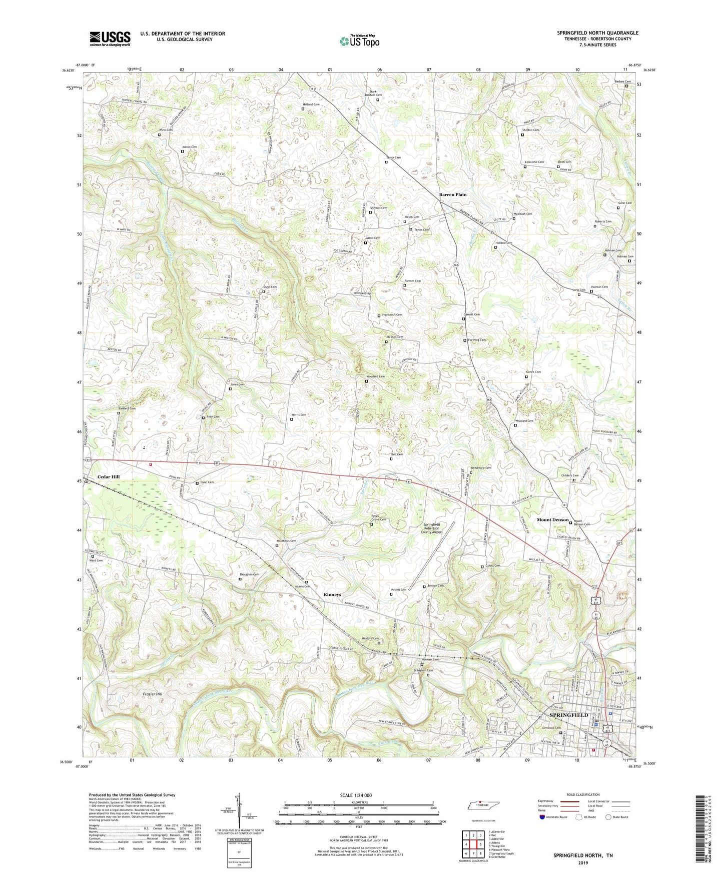
2019 topographic map quadrangle Springfield North in the state of Tennessee. Scale: 1:24000. Based on the newly updated USGS 7.5' US Topo map series, this map is in the following counties: Robertson. The map contains contour data, water features, and other items you are used to seeing on USGS maps, but also has updated roads and other features. This is the next generation of topographic maps. Printed on high-quality waterproof paper with UV fade-resistant inks.
Quads adjacent to this one:
West: Adams
Northwest: Allensville
North: Dot
Northeast: Adairville
East: Youngville
Southeast: Greenbrier
South: Springfield South
Southwest: Pleasant View
Contains the following named places: Adams Cemetery, Barbee Cemetery, Barren Plain, Barren Plains Baptist Church, Barren Plains Division, Barren Plains School, Bartlett Cemetery, Bell Cemetery, Benton Cemetery, Black Branch, Carr Creek, Cedar Hill, Cedar Hill Post Office, Cedar Hill School, Central Christian Church, Cheatham Park Elementary School, Childers Cemetery, Cohea Cemetery, Deen Cemetery, Draughan Cemetery, Dunn Cemetery, Elmwood Cemetery, Fairview Baptist Church, Fairview School, Faith Covenant Church, Farmer Cemetery, Farthing Cemetery, First Baptist Church, First Presbyterian Church, First United Methodist Church, Frazier Hill, Fyke Cemetery, Fykes Grove Cemetery, Fykes Grove Church, Garrett Cemetery, Green Cemetery, Gunn Cemetery, Highsmith Cemetery, Holland Cemetery, Holland School, Holman Cemetery, Hood Branch, Jackson Cemetery, Jesse Holman Jones Hospital, Jones Cemetery, Jones Chapel, Jones Store, Kinney School, Kinneys, Lipscomb Cemetery, Little Buzzard Creek, Long Cemetery, Manlove Cemetery, Mason Cemetery, Matthews Cemetery, McIntosh Cemetery, Morris Cemetery, Mount Denson, Mount Denson Cemetery, Mount Denson Cumberland Presbyterian Church, Mount Olive Baptist Church, Needmore Cemetery, Needmore School, North Springfield Baptist Church, Porters Chapel, Powell Cemetery, Roberts Cemetery, Robertson County Courthouse, Robertson County Emergency Medical Services, Robertson County Fairgrounds, Robertson County Rescue Squad and Fire Department, Robertson County Sheriff's Office, Shelton Cemetery, Sherrod Cemetery, Spring Creek, Spring Creek Church, Spring Creek School, Springfield, Springfield Baptist Church, Springfield City Hall, Springfield Fire Department Main Fire Station 1, Springfield Middle School, Springfield Police Department, Springfield Post Office, Springfield Robertson County Airport, Stark-Baldwin Cemetery, Taylor Cemetery, Taylor School, Ward Cemetery, Westside Elementary School, Winn Cemetery, Woodard Cemetery, WSGI-AM (Springfield)