MyTopo
Greenbrier Tennessee US Topo Map
Couldn't load pickup availability
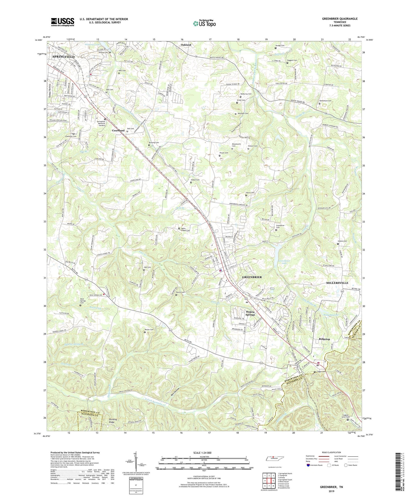
2022 topographic map quadrangle Greenbrier in the state of Tennessee. Scale: 1:24000. Based on the newly updated USGS 7.5' US Topo map series, this map is in the following counties: Robertson, Davidson, Sumner. The map contains contour data, water features, and other items you are used to seeing on USGS maps, but also has updated roads and other features. This is the next generation of topographic maps. Printed on high-quality waterproof paper with UV fade-resistant inks.
Quads adjacent to this one:
West: Springfield South
Northwest: Springfield North
North: Youngville
Northeast: Orlinda
East: White House
Southeast: Goodlettsville
South: Whites Creek
Southwest: Forest Grove
This map covers the same area as the classic USGS quad with code o36086d7.
Contains the following named places: Baggett Cemetery, Bell Cemetery, Ben Hollow, Bethlehem Cemetery, Bethlehem Church, Bethlehem School, Bloodworth Cemetery, Bowen Cemetery, Browing Cemetery, Calvary Church, Chambliss Cemetery, City of Ridgetop, City of Springfield, Coggin Cemetery, Coggins-Greer Cemetery, Commissioner District 3, Commissioner District 4, Commissioner District 5, Commissioner District 9, Courtland, Crawford Branch, Crossroads School, Dickerson Branch, Dorris Cemetery, Duncan Cemetery, Ebenezer Church, Eidson Cemetery, Elmore Cemetery, First Assembly of God Church, First Call Ambulance Service, Flat Branch, Gideon Cemetery, Gideon Church, Greenbrier, Greenbrier Cemetery, Greenbrier Elementary School, Greenbrier Fire Department, Greenbrier First Baptist Church, Greenbrier High School, Greenbrier Lake, Greenbrier Lake Dam, Greenbrier Middle School, Greenbrier Police Department, Greenbrier Post Office, Greenbrier Recreation Club Dam, Greenbrier Recreation Club Lake, Hall Cemetery, Hygeia Springs, Hygeia Springs Post Office, Kelly Willis School, Krisle Cemetery, Lights Chapel Cemetery, Long Branch, McMurray Cemetery, New Meyer Church, Oakland-Bethlehem School, Oppossum Fork, Our Lady of Lourdes Catholic Church, Paradise Lake, Paradise Lake Dam, Perry Park, Peyton Branch, Pinson Cemetery, Pinson School, Plainview School, Pole Bridge Branch, Possum Trot Hollow, Reeder School, Ridgetop, Ridgetop First Baptist Church, Ridgetop Lake, Ridgetop Lake Dam, Ridgetop Police Department, Ridgetop Post Office, Ridgetop Volunteer Fire Department, Rock Springs Cemetery, Rock Springs Church, Santee Creek, Savage Branch, Savage Cemetery, Springfield Fire Department David N Greer Fire Station 2, Springfield Memorial Gardens, Springfield-Greenbrier Division, Sulphur Spring Branch, Town of Greenbrier, Wartrace Church, Watauga High School, White House Community Volunteer Fire Department Station 52, Wolf Branch, Worsham Cemetery, ZIP Code: 37073