
MyTopo
Stony Point Tennessee US Topo Map
Couldn't load pickup availability
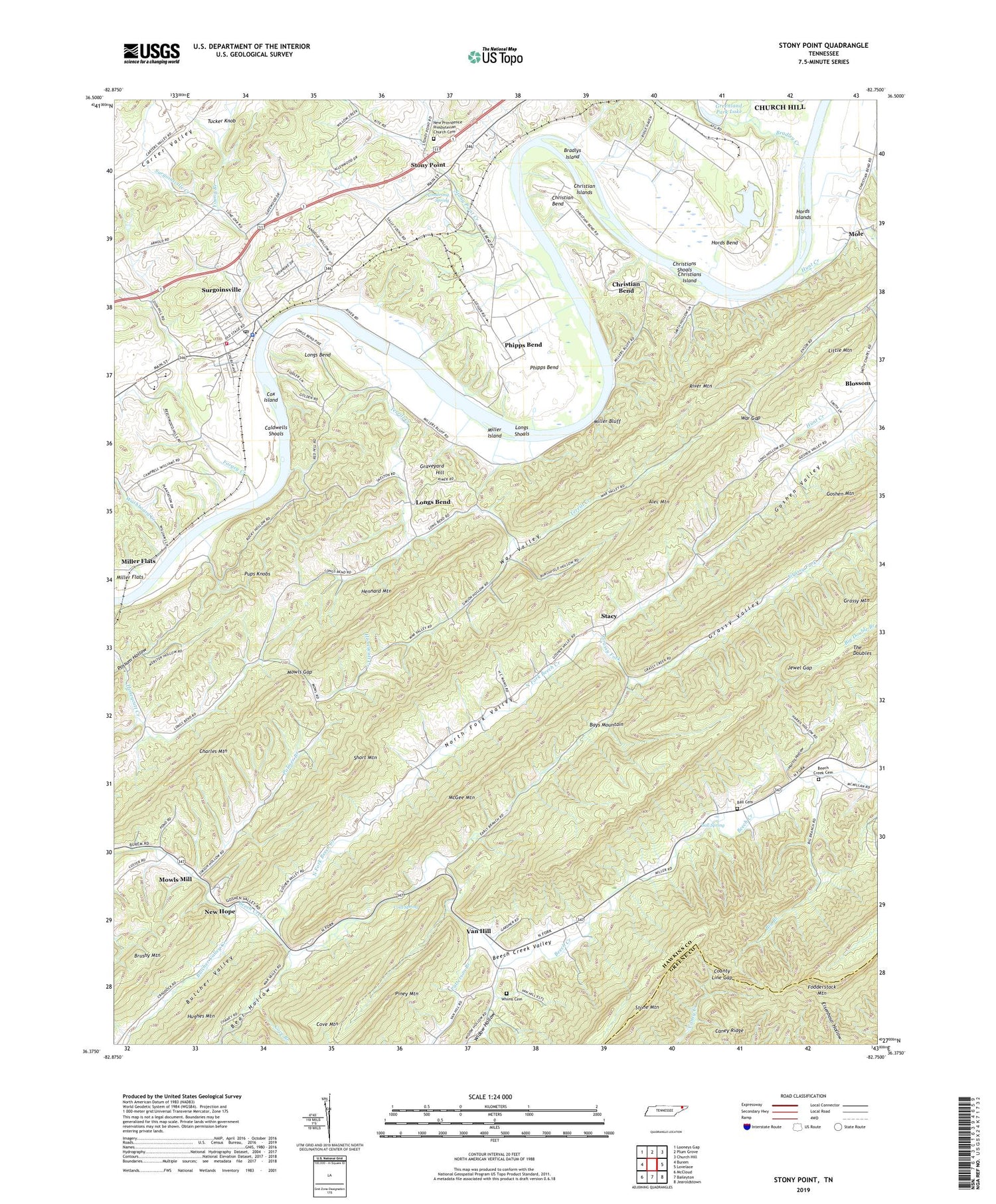
2019 topographic map quadrangle Stony Point in the state of Tennessee. Scale: 1:24000. Based on the newly updated USGS 7.5' US Topo map series, this map is in the following counties: Hawkins, Greene. The map contains contour data, water features, and other items you are used to seeing on USGS maps, but also has updated roads and other features. This is the next generation of topographic maps. Printed on high-quality waterproof paper with UV fade-resistant inks.
Quads adjacent to this one:
West: Burem
Northwest: Looneys Gap
North: Plum Grove
Northeast: Church Hill
East: Lovelace
Southeast: Jearoldstown
South: Baileyton
Southwest: McCloud
Contains the following named places: Alec Mountain, Armstrong Spring, Ball Cemetery, Ball Spring, Bear Hollow, Beech Creek Cemetery, Beech Creek Division, Beech Creek Valley, Bernard Hollow, Big Branch, Blossom, Bradley Creek, Bradlys Island, Britton Ferry, Butcher Valley Creek, Caldwells Shoals, Charles Mountain, Chimneytop, Christian Bend, Christian Islands, Christians Bend School, Christians Ford, Christians Island, Christians Shoals, Cold Spring, Commissioner District 4, County Line Gap, Cove Branch, Cove Mountain, Cox Island, Dykes Store, Fodderstack Mountain, Forgey Creek, Freewill Church, Glendale School, Grassy Fork, Grassy Mountain, Grassy Valley, Graveyard Hill, Greenland Park Dam, Greenland Park Lake, Harris Hollow, Hennard Mountain, Hords Bend, Hords Islands, Hunt Creek, Jewel Gap, Kincheloe, Little Mountain, Lone Star School, Longs Bend, Longs Bend Baptist Church, Longs Shoals, Lower Grassy School, Lyons Ford, Lyons Store, Maxwell Academy, McGee Mountain, Miller Bluff, Miller Flats, Miller Island, Mole, Mowls Gap, Mowls Mill, New Hope, New Hope Baptist Church, New Hope School, New Providence Presbyterian Church, New Providence Presbyterian Church Cemetery, North Fork, North Fork Baptist Church, North Fork Beech Creek, North Fork School, North Fork Valley, Palmer Branch, Patterson Branch, Phipps Bend, Pups Knobs, River Mountain, Short Mountain, Smith Chapel, Stacy, Stone Mountain, Stony Point, Stony Point Creek, Surgoinsville, Surgoinsville Baptist Church, Surgoinsville Creek, Surgoinsville Division, Surgoinsville Elementary School, Surgoinsville Fire Station 1, Surgoinsville Middle School, Surgoinsville Police Department, Surgoinsville Post Office, Terrill Creek, Town of Surgoinsville, Tucker Knob, Van Hill, Van Hill School, War Gap, War Valley, Washboard Creek, Waste Lagoon, Waste Lagoon Dam, Whims Cemetery, Widow Hollow, Young Branch


