
MyTopo
Tiptonville Tennessee US Topo Map
Couldn't load pickup availability
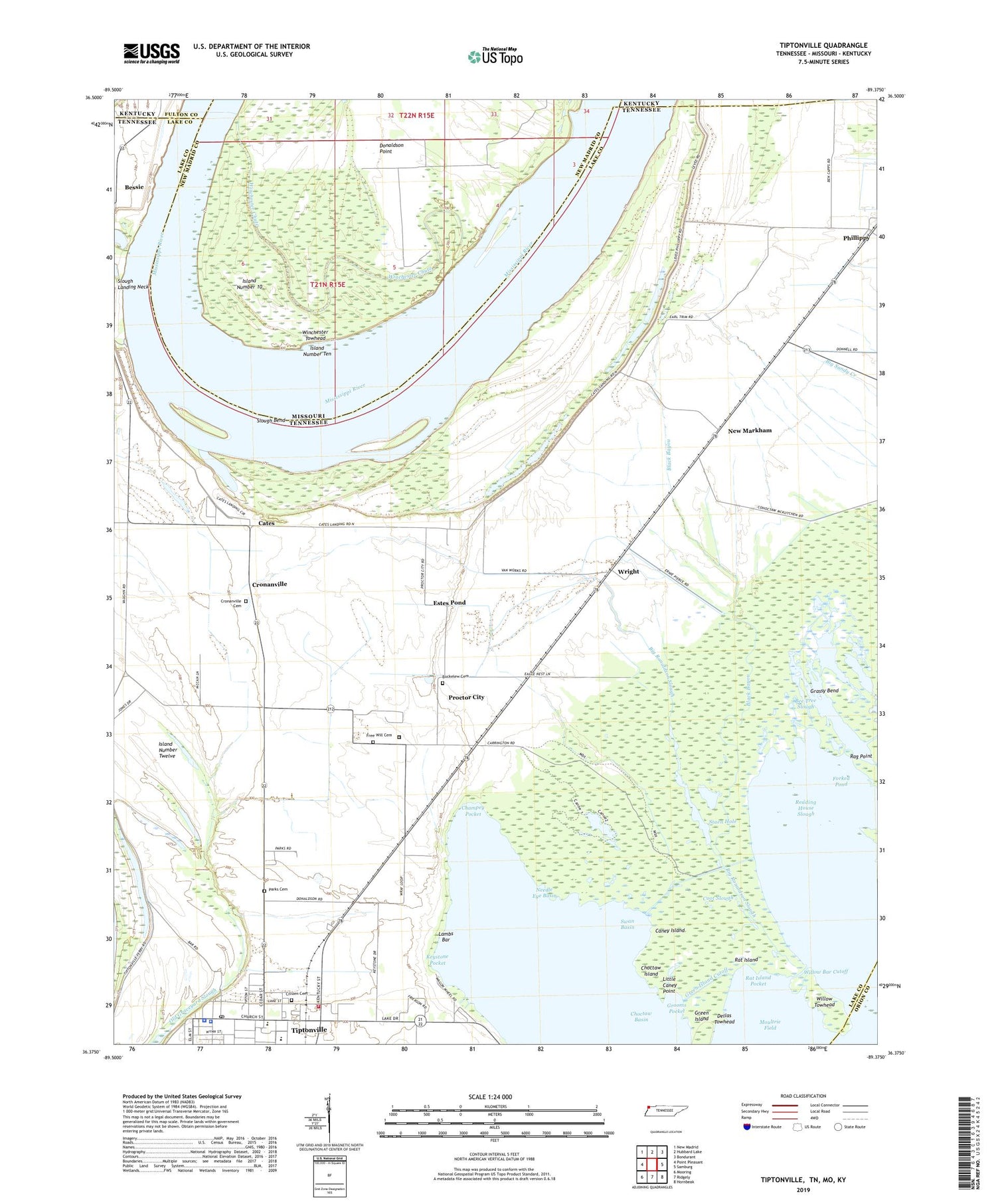
2019 topographic map quadrangle Tiptonville in the states of Tennessee, Missouri. Scale: 1:24000. Based on the newly updated USGS 7.5' US Topo map series, this map is in the following counties: Lake, New Madrid, Fulton, Obion. The map contains contour data, water features, and other items you are used to seeing on USGS maps, but also has updated roads and other features. This is the next generation of topographic maps. Printed on high-quality waterproof paper with UV fade-resistant inks.
Quads adjacent to this one:
West: Point Pleasant
Northwest: New Madrid
North: Hubbard Lake
Northeast: Bondurant
East: Samburg
Southeast: Hornbeak
South: Ridgely
Southwest: Mooring
Contains the following named places: Bee Tree Slough, Bessie, Bessie Landing, Big Ronaldson Slough, Black Bayou, Buckelew Cemetery, Calhoun Boat Dock, Caney Island, Cates, Cates Landing, Cates School, Champey Pocket, Choctaw Basin, Choctaw Island, Citizen Cemetery, Commissioner District 1, Cook Pond, Coot Slough, Cronanville, Cronanville Cemetery, Cronanville Cumberland Presbyterian Church, Dellas Towhead, Donaldson Point, Estes Pond, Forked Pond, Free Will Cemetery, Free Will Church, Goochs Camp, Goochs Landing, Grassy Bend, Gray Duck Hole, Green Island, Green Island Cutoff, Grooms Pocket, Island Number 10, Island Number Nine Revetment, Island Number Ten, Island Number Twelve, Katies Gourd, Keystone Pocket, Lake County Courthouse, Lake County Emergency Medical Services, Lake County High School, Lake County Sheriff's Office, Lake County Shopping Center, Lambs Bar, Little Caney Point, Margaret Newton Elementary School, Moultrie Field, Mount Zion Church, Needle Eye Basin, New Markham, Northwest Correctional Complex, Old Slough Landing, Parks Cemetery, Phillippy, Phillippy Baptist Church, Phillippy School, Proctor City, Race Track, Rag Point, Rat Island, Rat Island Pocket, Rays Camp, Reading House Slough, Reelfoot State Wildlife Management Area, Saint Johns Church, Slough Bend, Slough Landing Neck Revetment, Staen Hole, Starve Pond, Swan Basin, Tiptonville, Tiptonville City Hall, Tiptonville Division, Tiptonville Fire Department, Tiptonville First Baptist Church, Tiptonville Police Department, Tiptonville Post Office, Tiptonville Public Library, Watson Point Dike, Willow Bar Cutoff, Willow Towhead, Winchester Chute, Winchester Towhead, Wright, ZIP Code: 38079


