MyTopo
Whitleyville Tennessee US Topo Map
Couldn't load pickup availability
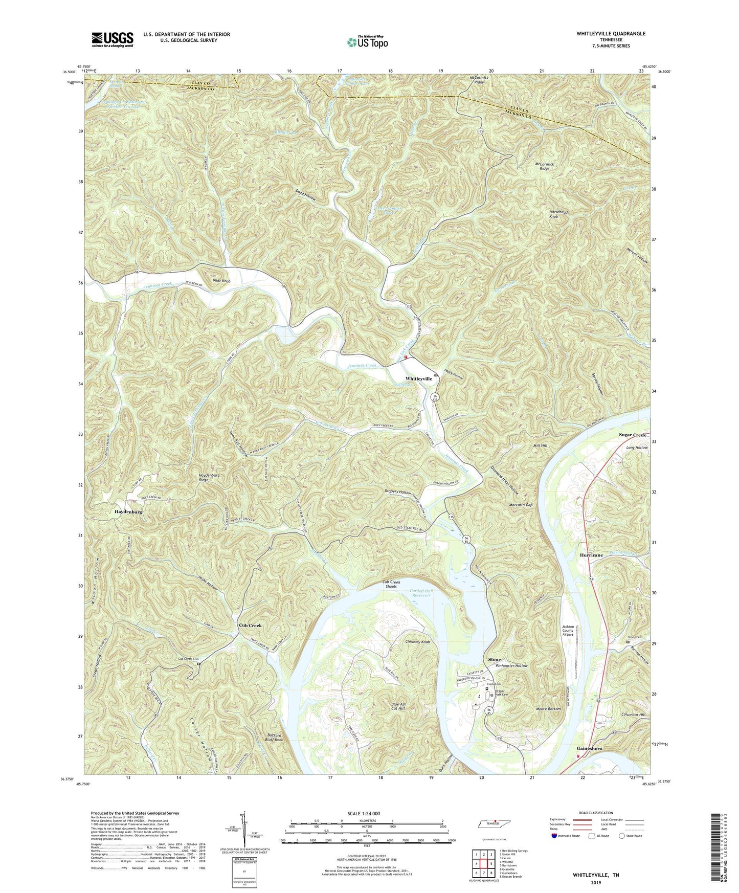
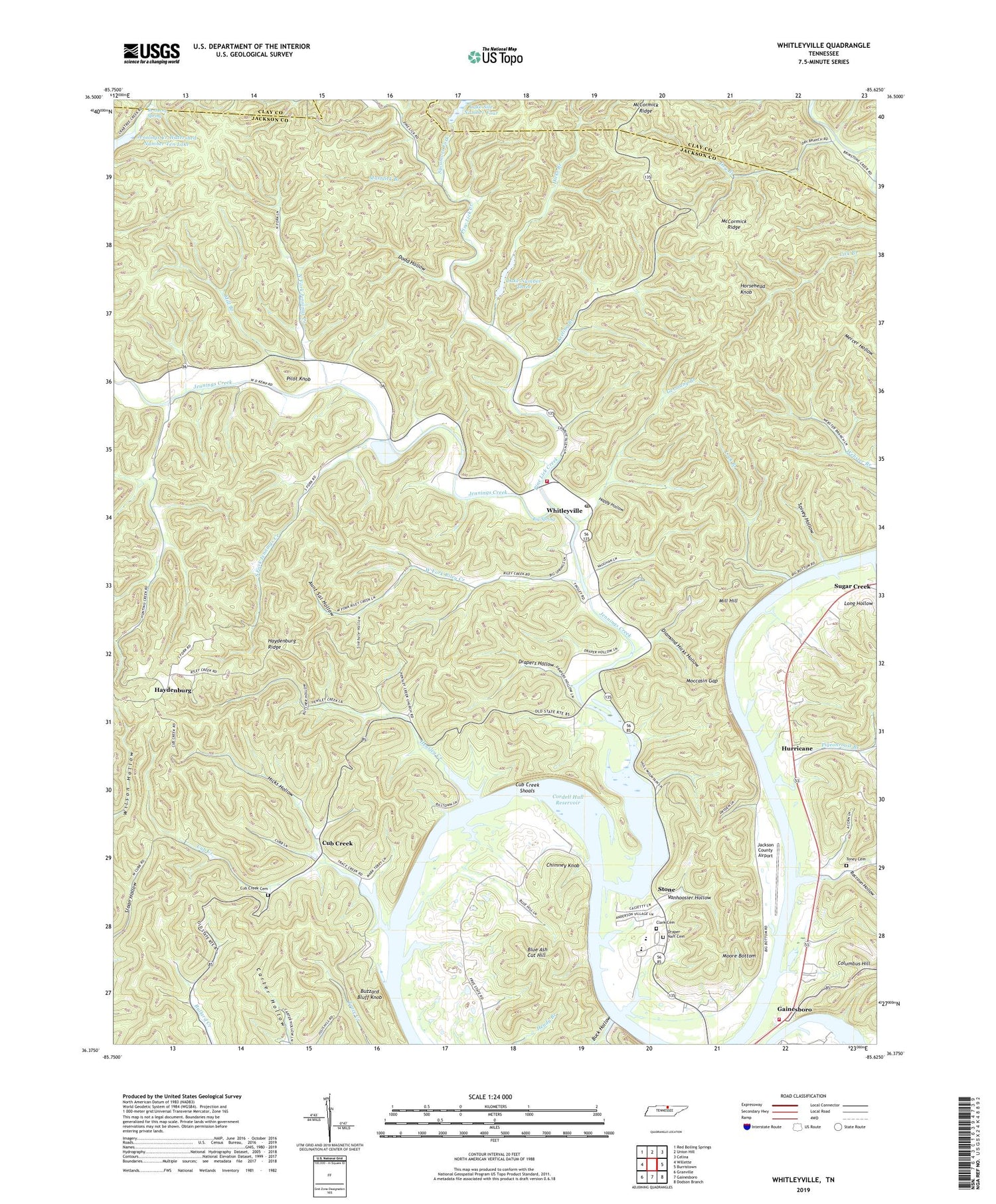
2019 topographic map quadrangle Whitleyville in the state of Tennessee. Scale: 1:24000. Based on the newly updated USGS 7.5' US Topo map series, this map is in the following counties: Jackson, Clay. The map contains contour data, water features, and other items you are used to seeing on USGS maps, but also has updated roads and other features. This is the next generation of topographic maps. Printed on high-quality waterproof paper with UV fade-resistant inks.
Quads adjacent to this one:
West: Willette
Northwest: Red Boiling Springs
North: Union Hill
Northeast: Celina
East: Burristown
Southeast: Dodson Branch
South: Gainesboro
Southwest: Granville
Contains the following named places: Allen School, Arbor School, Aunt Sal Hollow, Big Spring, Blue Ash Cut Hill, Buck Hollow, Buzzard Bluff Knob, Cane Island, Chimney Knob, Clark Cemetery, Columbus Hill, Commissioner District 6, Cub Creek, Cub Creek Cemetery, Cub Creek Island, Cub Creek School, Cub Creek Shoals, Diamond Hicks Hollow, Dodd Hollow, Draper-Naff Cemetery, Drapers Hollow, Dry Branch, Free State, Free State School, Germany Branch, Gum Springs School, Happy Hollow, Haydenburg, Haydenburg Ridge, Hensley Creek, Hensley Creek Church, Hensley Creek School, Hicks Branch, Hicks Ferry, Hicks Hollow, Horsehead Knob, Hunting Creek, Hurricane, Hurricane Branch, Hurricane Church, Hurricane School, Jackson County Airport, Jackson County Central Fire Department, Jennings Creek, Jennings Creek Volunteer Fire Department, Jennings Creek Watershed Dam Number Four, Jennings Creek Watershed Dam Number Three, Jennings Creek Watershed Number Ten Lake, Keeling Branch, Kentucky Spring, Lake Number Three, Lake Site Number Four, Lees Landing, Lock Branch, Lock Branch Landing, Lock Branch School, Mashlick Branch, McCormick Ridge, Mill Branch, Mill Hill, Moccasin Gap, Moore Bottom, North Fork Jennings Creek, North of the River Division, Pigeonroost Branch, Pilot Knob, Pine Lick Creek, Raccoon Hollow, Riley Creek, Roaring River Recreational Area, Sal Branch, Simpson Island, Sinkhole Hollow, South Fork Church, South Fork Jennings Creek, SouthFork School, Spivey Hollow, Stone, Stone School, Sycamore Fork, Tennessee Department of Agriculture Division of Forestry Haydenburg Fire Tower, Toney Cemetery, Vanhoosier Hollow, West Fork Riley Creek, Whitleyville, Whitleyville Post Office, Whitleyville School, Willow Grove Church, Willow Grove School, ZIP Code: 38588