MyTopo
Denton West Texas US Topo Map
Couldn't load pickup availability
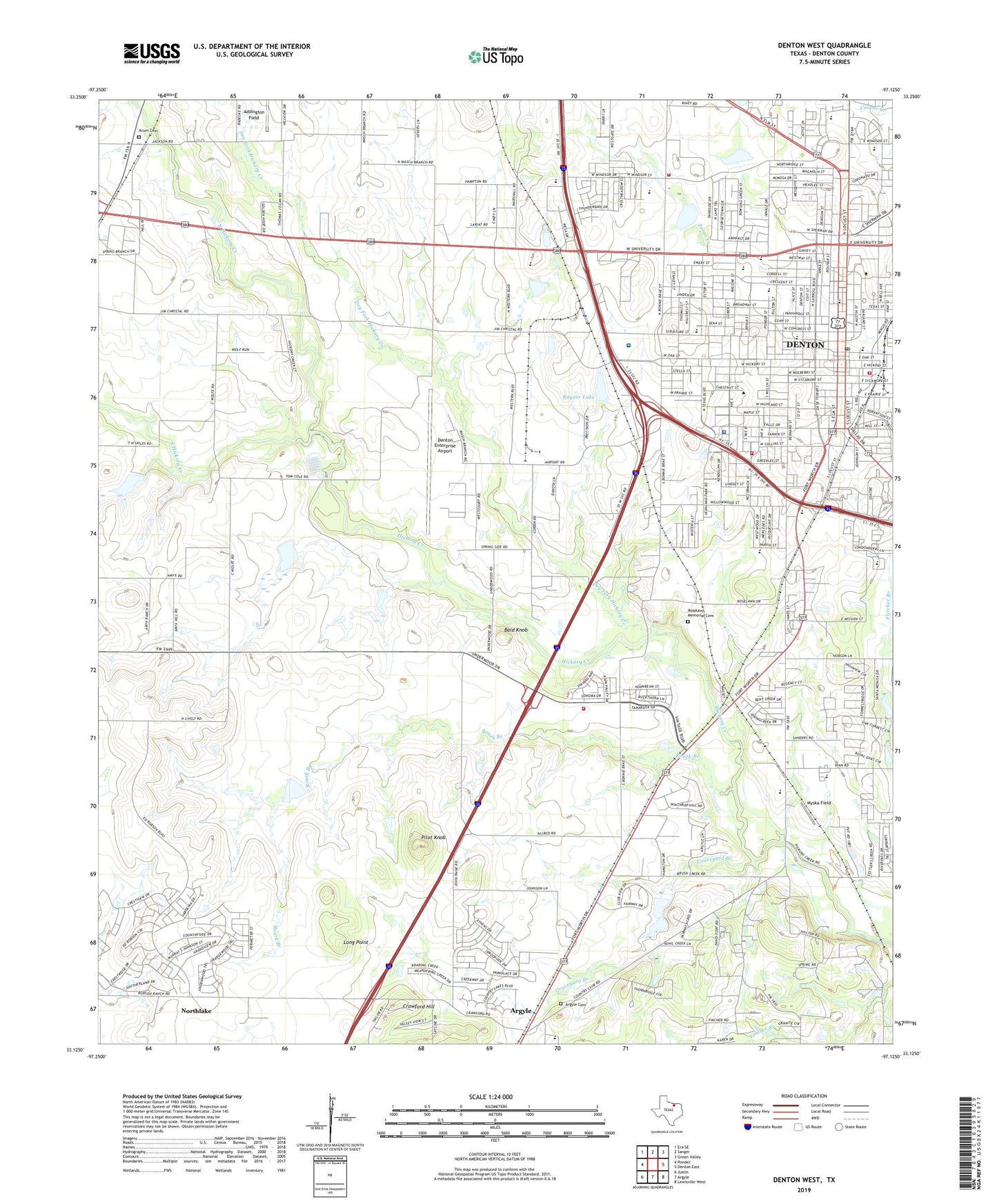
2019 topographic map quadrangle Denton West in the state of Texas. Scale: 1:24000. Based on the newly updated USGS 7.5' US Topo map series, this map is in the following counties: Denton. The map contains contour data, water features, and other items you are used to seeing on USGS maps, but also has updated roads and other features. This is the next generation of topographic maps. Printed on high-quality waterproof paper with UV fade-resistant inks.
Quads adjacent to this one:
West: Ponder
Northwest: Era SE
North: Sanger
Northeast: Green Valley
East: Denton East
Southeast: Lewisville West
South: Argyle
Southwest: Justin
Contains the following named places: A O Calhoun Middle School, Addington Field, Apostolic Assembly Church, Asbury United Methodist Church, Bald Knob, Borman Elementary School, Central Baptist Church, Christ Community Church, Church of Christ, Church of God, City of Denton, Country Club Lake, Country Club Lake Dam, Crawford Hill, Denia Park, Denton, Denton City Hall, Denton Country Club, Denton County Constable's Office Precinct 1, Denton County Courthouse, Denton County Historical Museum, Denton Division, Denton Enterprise Airport, Denton Fire Department Station 1, Denton Fire Department Station 3, Denton Fire Department Station 5, Denton Fire Department Station 7, Denton High School, Denton Independent School District Stadium, Denton Post Office, Denton Regional Medical Center-Flow Campus Heliport, Dry Fork Hickory Creek, Dwight Gailey Stadium, Evers Park, Evers Park Elementary School, First Baptist Church of Denton, First Presbyterian Church USA, Flow Hospital, Fouts Field, Fred Moore Learning Center, Gateway United Baptist Church, Grace Temple Baptist Church, Graham - Argyle Cemetery, Graveyard Branch, Hanger 10 Flying Museum, Hillcrest Baptist Church, Jagoe, Krum Cemetery, Lindsey Assembly of God Church, Long Point, McKenna Park, McMath Middle School, Minchin, Mount Pilgrim Church, Myska Field, Nelson Learning Center, New Creation Fellowship Church, North Hickory Creek, North Lakes Park, North Lakes Park Trail, North Texas State College, North Texas State College Golf Course, Pilot Knob, Presbyterian Hospital of Denton, Rayzor Elementary School, Rayzor Lake, Rayzor Lake Dam, Redeemer Presbyterian Church, Roark Branch, Robert E Lee School, Roselawn Memorial Cemetery, Saint Andrew Presbyterian Church, Saint Davids Episcopal Church, Sam Houston School, Soil Conservation Service Site 11 Dam, Soil Conservation Service Site 12 Dam, Soil Conservation Service Site 13 Dam, Soil Conservation Service Site 13 Reservoir, Soil Conservation Service Site 14 Dam, Soil Conservation Service Site 14 Reservoir, Soil Conservation Service Site 16 Dam, Soil Conservation Service Site 16 Reservoir, Soil Conservation Service Site 17a Dam, Soil Conservation Service Site 17a Reservoir, Soil Conservation Service Site Number 11 Reservoir, Soil Conservation Service Site Number 12 Reservoir, South Hickory Creek, South Lakes Park Trail, Strickland Middle School, Tabernacle Baptist Church, Texas A and M College Experimental Station Number 6, Texas Womans University, Texas Woman's University Post Office, The Church of Jesus Christ of Latter Day Saints, Touchstone Academy, Trinity Presbyterian Church, University Behavioral Health of Denton, University Evangelical Methodist Church, University of North Texas Coliseum, University of North Texas Mens Gym, University of North Texas Police Department, ZIP Codes: 76201, 76205, 76207