MyTopo
Ennis West Texas US Topo Map
Couldn't load pickup availability
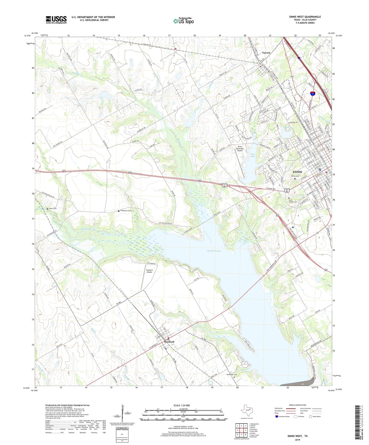
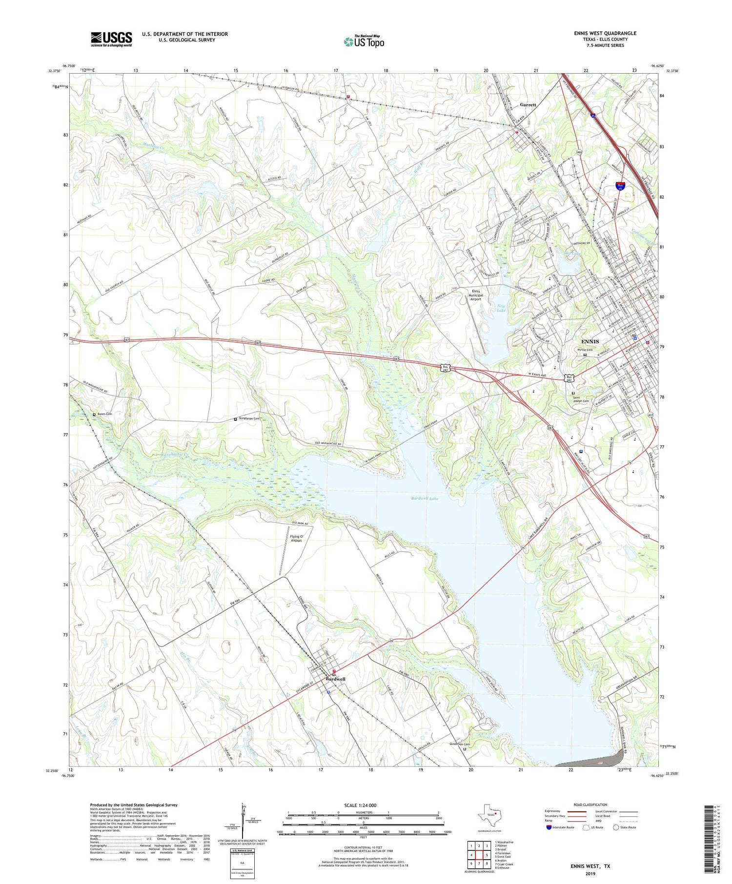
2019 topographic map quadrangle Ennis West in the state of Texas. Scale: 1:24000. Based on the newly updated USGS 7.5' US Topo map series, this map is in the following counties: Ellis. The map contains contour data, water features, and other items you are used to seeing on USGS maps, but also has updated roads and other features. This is the next generation of topographic maps. Printed on high-quality waterproof paper with UV fade-resistant inks.
Quads adjacent to this one:
West: Forreston
Northwest: Waxahachie
North: Palmer
Northeast: Bristol
East: Ennis East
Southeast: Emhouse
South: Cryer Creek
Southwest: Avalon
Contains the following named places: Anthony Drive Church, Austin Elementary School, Bardwell, Bardwell Dam, Bardwell Lake, Bardwell Post Office, Bardwell Volunteer Fire Department, Barkley-Floyd House, Barrington House, Bethel Church, Big Mustang Creek Park, Bluebonnet City Park, Boren Cemetery, Bowie Elementary School, Church of God, City of Bardwell, City of Ennis, E K Atwood House, E T Boren House, East Side Church of Christ, Ennis, Ennis City Hall, Ennis Commercial Historic District, Ennis Fire Department Central Station, Ennis High School, Ennis Independent School District Police Department, Ennis Junior High School, Ennis Municipal Airport, Ennis Police Department, Ennis Post Office, Ennis Regional Medical Center, Fain House, First Baptist Church, Flying O Airport, Fourth Ward Baptist Church, Friendship Baptist Church, G G Dunkerly House, Galilee Baptist Church, Garrett, Garrett Area Rural Volunteer Fire Department Main Station, Garrett City Hall, Garrett Volunteer Fire Department, Gilmer Baldridge Church of Christ, Grace Lutheran Church, H and TC Railroad Division Yard Shop, High View Park, Houston Elementary School, I R Allen House, Independent Baptist Church, James S Sanderson House, Jaycee Park, Jesse and Mary Story House, Joe Novy House, John M Weekley House, Jolesch House, Kachine Prairie Park, Kiwanis Park, Lake Clark, Lake Clark Dam, Lake Clark Park, Lakeside Country Club, Lions Stadium, Little Mustang Creek Park, Lower Love Park, Matthews-Atwood House, Matthews-Templeton House, McCanless-Williams House, Mein Hope Church, Meredith-McDowal House, Miller School, Moore House, Morton House, Mott Park, Mount Olive Baptist Church, Myrtle Cemetery, Neal House, New Jerusalem Baptist Church, New Lake, Old City Lake Dam, Old City Mills, Old Lake, Pierce Park, Range Reservoir, Ransom House, Raphael House, Saint Joseph Cemetery, Saint Paul Missionary Baptist Church, Saint Thomas Church, Saint Thomas Episcopal Church, Sanderson Cemetery, Sharp House, Soil Conservation Service Site 118 Dam, Soil Conservation Service Site 118 Reservoir, Soil Conservation Service Site 19 Dam, Soil Conservation Service Site 19 Reservoir, Soil Conservation Service Site 20 Dam, Soil Conservation Service Site 20 Reservoir, Tabernacle Baptist Church, Telfair House, Templeton Cemetery, Town of Garrett, Waxahachie Creek Park, Waxahachie Trail, Weatherford House, Wolf Branch, Zion Chapel Baptist Church, ZIP Code: 75101