MyTopo
Hebron Texas US Topo Map
Couldn't load pickup availability
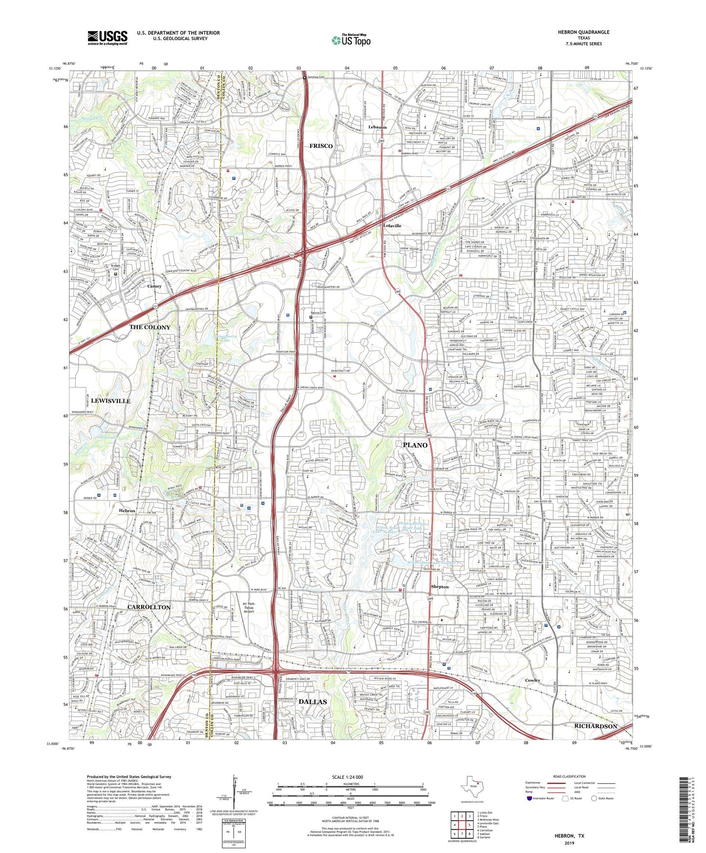
2023 topographic map quadrangle Hebron in the state of Texas. Scale: 1:24000. Based on the newly updated USGS 7.5' US Topo map series, this map is in the following counties: Collin, Denton. The map contains contour data, water features, and other items you are used to seeing on USGS maps, but also has updated roads and other features. This is the next generation of topographic maps. Printed on high-quality waterproof paper with UV fade-resistant inks.
Quads adjacent to this one:
West: Lewisville East
Northwest: Little Elm
North: Frisco
Northeast: McKinney West
East: Plano
Southeast: Garland
South: Addison
Southwest: Carrollton
This map covers the same area as the classic USGS quad with code o33096a7.
Contains the following named places: African Methodist Episcopal Cornerstone Church, Air Park-Dallas Airport, Arbor Creek Middle School, Arbor Hills Nature Preserve Trail, B B Owen Elementary School, Baccus Cemetery, Barksdale Elementary School, Baylor Regional Medical Center at Plano, Baylor Scott and White Medical Center - Centennial, Baylor Scott and White Medical Center - Frisco, Bettye Haun Elementary School, Bridges Cemetery, Buckhorn Park, Camey, Carpenter Park Trail, Carrollton Fire Department Station 4, Cheyenne Park, Childrens Presbyterian Health Center of North Texas Heliport, Christ Our King Community Church, Christian Life Assembly of God Church, Churchill Way Presbyterian Church, Claude Curtsinger Elementary School, Coit Post Office, Colony Park Baptist Church, Cornerstone Baptist Church, Cowley, Donald H Sheffield Intermediate Elementary School, E D S Heliport, Evans Park, First Baptist Church Hebron, Frisco Fire Department Station 2, Frisco Fire Department Station 3, Furneaux Elementary School, Grace Presbyterian Church, Hebron, Hebron High School Baseball Field, Hebron High School Football Stadium, Hebron High School Softball Stadium, Hightower Elementary School, Huffman Elementary School, Jackson Elementary School, Jasper High School, JC Penny Historical Museum, John Marshall Daffron Elementary School, Lebanon, Lebanon Baptist Church, Liberty Church, LifeCare Hospital of Plano, Lolaville, Lord of Life Lutheran Church, Mathews Elementary School, Mcp Heliport, Medical City Plano, Morningside Elementary School, Mount Olivet Baptist Church of Plano, Northwest Plano Post Office, Parkway Hills Baptist Church, Pilot Point Waste Water Treatment Plant, Plano Fire Department Station 10, Plano Fire Department Station 5, Plano Fire Department Station 7, Plano Fire Department Station 8, Plano Fire Department Station 9, Plano Senior High School, Plano Specialty Hospital, Preston Meadow Lutheran Church, Preston Shepard Place Shopping Center, Preston Towne Crossing Shopping Center, Quisenberry Lake, Quisenberry Lake Dam, Regency Hospital of North Dallas, Renner Middle School, Robinson Middle School, Russell Creek Park Trail, Saigling Elementary School, Saint Paul Lutheran Church, Select Specialty Hospital - Dallas, Shepton, Shepton High School, Shiff Lake, Shiff Lake Dam, Shirley Phillips Mead Dam, Shirley Phillips Mead Lake, Skaggs Elementary School, Smith Elementary School, Sonntag Cemetery, Stewart Creek West Water Treament Facility, Stonebriar Centre Shopping Center, Texas Health Center for Diagnostics and Surgery, Texas Health Presbyterian Hospital of Plano, Texas Health Presbyterian Plano Seay Behavioral Health Center, The Colony Fire Department Station 2, The Heart Hospital at Baylor Plano, The Shops at Willow Bend, W O Haggard Junior Library, Weatherford Elementary School, Wells Elementary School, White Rock Trail, Wildcat Post Office, Willow Bend Baptist Church, Willow Bend Lake Number 1, Willow Bend Lake Number 1 Dam, Willow Bend Lake Number 2, Willow Bend Lake Number 2 Dam, ZIP Codes: 75010, 75024, 75093