MyTopo
Orangefield Texas US Topo Map
Couldn't load pickup availability
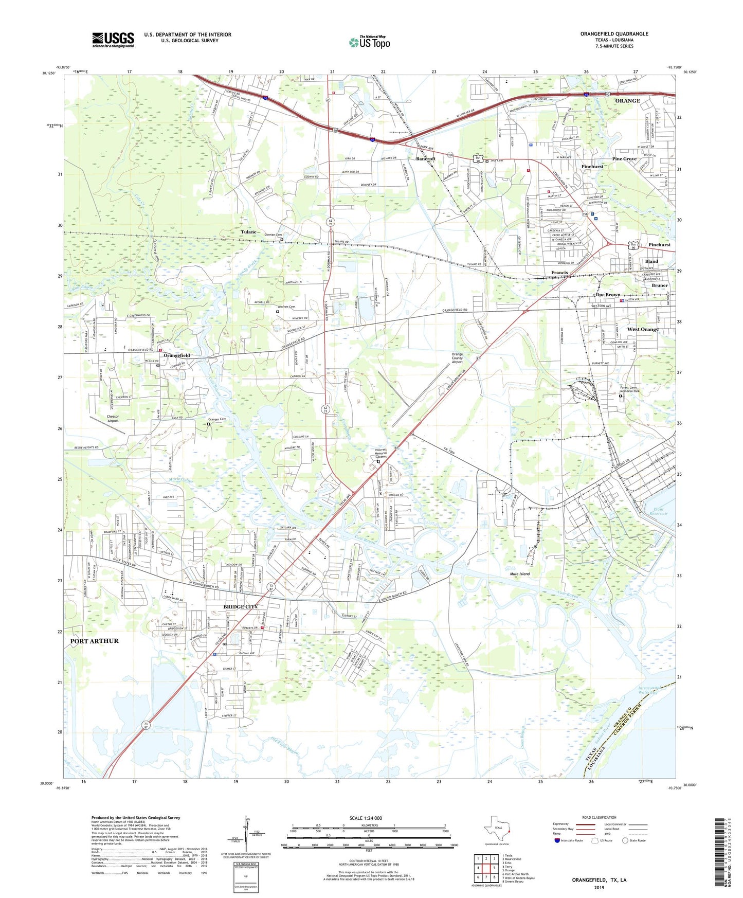
2019 topographic map quadrangle Orangefield in the state of Texas. Scale: 1:24000. Based on the newly updated USGS 7.5' US Topo map series, this map is in the following counties: Orange, Cameron. The map contains contour data, water features, and other items you are used to seeing on USGS maps, but also has updated roads and other features. This is the next generation of topographic maps. Printed on high-quality waterproof paper with UV fade-resistant inks.
Quads adjacent to this one:
West: Terry
Northwest: Texla
North: Mauriceville
Northeast: Echo
East: Orange
Southeast: Greens Bayou
South: West of Greens Bayou
Southwest: Port Arthur North
Contains the following named places: Acadian Ambulance Service, Bancroft, Bancroft Elementary School, Bancroft School, Baptist Hospitals of Southeast Texas Orange Campus, Bland, Bridge City, Bridge City Hall, Bridge City High School, Bridge City Intermediate School, Bridge City Junior High School, Bridge City Police Department, Bridge City Post Office, Bridge City Volunteer Fire and Rescue, Bridge City Volunteer Fire and Rescue Orangefield Station, Bruner, Chesson Airport, Church of Christ, Church of Christ in West Orange, Church of the Nazarene, Circle Drive Baptist Church, City of Bridge City, City of Orange, City of Pinehurst, City of West Orange, Cole Creek, Coon Bayou, Doc Brown, Dorman Cemetery, First Baptist Church of West Orange, Forest Lawn Memorial Park, Francis, Grace Baptist Church, Granger Cemetery, Greater New Rising Star Baptist Church, Harbor Hospital of Southeast Texas, Hatton Elementary School, Hillcrest Memorial Gardens, Jett Cemetery, KLVI-AM (Beaumont), Lower Neches Wildlife Management Area - Old River, Mac Arthur Heights Baptist Church, Marie Gully, McLewis School, McLewis Volunteer Fire Department, Memorial Field Park, Mule Island, Oates Elementary School, Orange County Airport, Orange County Constable's Office Precinct 2, Orange County Constable's Office Precinct 3, Orange Division, Orange Fire Department Station 3, Orangefield, Orangefield Pentecostal Church, Orangefield Post Office, Pine Grove, Pinehurst, Pinehurst City Hall, Pinehurst Police Department, Pinehurst Volunteer Fire Department, Plant Reservoir, Saint Mark Lutheran Church, Saint Paul United Methodist Church, Sandy Creek, Second Baptist Church, Shell Canal, Sims Elementary School, Sunset Grove Country Club, Texas Department of Public Safety - Highway Patrol Office, The W H Stark Home, Thomas Cemetery, Tulane, United Pentecostal Church of Pinehurst, West Orange, West Orange - Stark High School, West Orange - Stark Intermediate School, West Orange City Hall, West Orange Police Department, West Orange Volunteer Fire Department, West Park, Winfree Cemetery, Winfree Church, ZIP Codes: 77611, 77630