MyTopo
Seagoville Texas US Topo Map
Couldn't load pickup availability
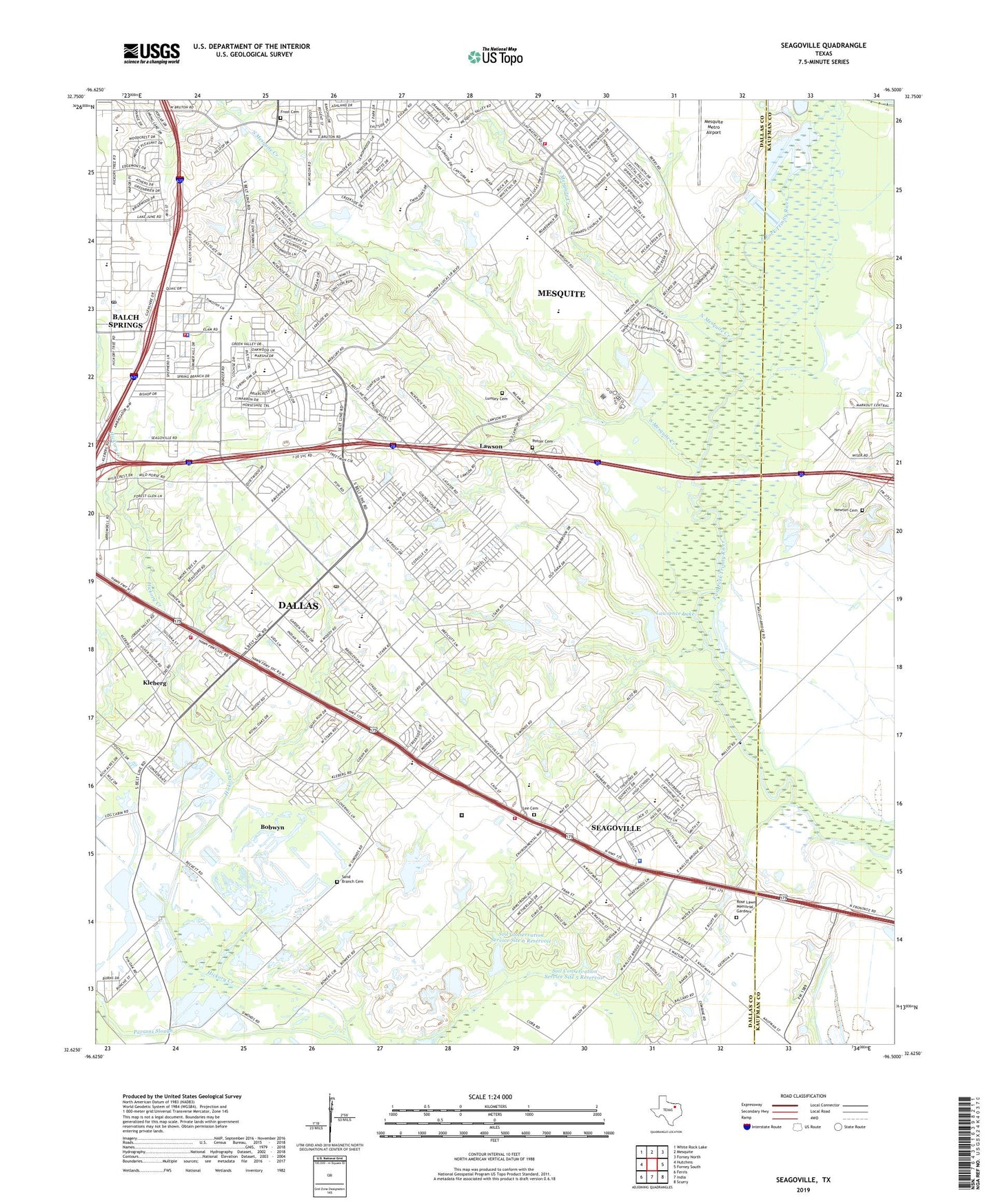
2019 topographic map quadrangle Seagoville in the state of Texas. Scale: 1:24000. Based on the newly updated USGS 7.5' US Topo map series, this map is in the following counties: Dallas, Kaufman. The map contains contour data, water features, and other items you are used to seeing on USGS maps, but also has updated roads and other features. This is the next generation of topographic maps. Printed on high-quality waterproof paper with UV fade-resistant inks.
Quads adjacent to this one:
West: Hutchins
Northwest: White Rock Lake
North: Mesquite
Northeast: Forney North
East: Forney South
Southeast: Scurry
South: India
Southwest: Ferris
Contains the following named places: A C New Middle School, Antioch Baptist Church, B J Smith Elementary School, Balch Springs, Balch Springs Church of Christ, Balch Springs City Hall, Balch Springs City Marshal, Balch Springs Fire Department, Balch Springs Police Department, Balch Springs Post Office, Beardon Park, Berry Middle School, Bethel Baptist Church, Bethlehem Primitive Baptist Church, Blessed Hope Baptist Church, Bobwyn, Bruton Park, Calvary Assembly of God Church, Calvary Church, Calvary Temple Assembly of God Church, Carver School, Central Elementary School - Dallas, Chapel of Praise Dallas Church, Chiesl Baseball Complex, Church of the Royal Law, City of Balch Springs, City of Seagoville, Cityof Seagoville Wastewater Treatment Plant, Creech Heliport, Dallas Fire and Rescue Station 9, Destiny Worship Center, Fairhaven Baptist Church, Faith Church of God, Federal Correctional Institution Seagoville, Fellowship Holiness Church, First Baptist Church - Kleberg, First Southern Baptist Church of Balch Springs, Floyd Elementary School, Frost Cemetery, Full Gospel Baptist Church, Gethsemane Baptist Church, Grace Baptist Church, Heard Park, Hickory Creek, Hickory Tree Baptist Church, Highland Meadows Assembly of God Church, Hodges Elementary School, Hodges Park, James Ray Henry Stadium, Joey M Pirrung Elementary School, Kimi Heliport, Kleberg, Kleberg Church of Christ, Kleberg Elementary School, Lake Number Nine Dam, Lawrence Lake, Lawrence Lake Dam, Lawson, Lee Cemetery, Lew Park, Lucas Lake, Lucas Lake Dam, Lumley Cemetery, McWhorter Elementary School, McWhorter Park, Mesquite Fire Department Station 7, Mesquite Metro Airport, Mesquite Sewage Disposal, Mesquite Valley Baptist Church, Mount Zion Baptist Church, New Beginnings Baptist Church, New Heights Baptist Church, Newton Cemetery, North Mesquite Creek, Oak Hill Assembly of God Church, Pleasant Haven Church, Potter Cemetery, Praise Temple Church of God in Christ, Quiet Wood Baptist Church, Robinwood Baptist Church, Rose Lawn Memorial Gardens, Saint Timothy Church, Sand Branch Cemetery, Sand Branch Church, Sandhill Baptist Church, Seagoville, Seagoville Alternative Learning Center, Seagoville City Hall, Seagoville Elementary School, Seagoville Fire Department, Seagoville First Baptist Church, Seagoville Middle School, Seagoville Police Department, Seagoville Post Office, Seagoville Sewage Disposal, Shady Grove Baptist Church, Soil Conservation Service Site 5 Dam, Soil Conservation Service Site 5 Reservoir, Soil Conservation Service Site 6 Dam, Soil Conservation Service Site 6 Reservoir, South Mesquite Creek, South Mesquite Creek Wastewater Treatment Plant, Spring Oaks Baptist Church, Texas Lifeline Corporation Ambulance Balch Springs, Texas Lifeline Corporation Ambulance Service, Thompson Elementary School, Union Chapel Baptist Church, Valley Creek Greenbelt Trail, Valley View Baptist Church, Victory Baptist Church, Wayside Church, Wayside Missionary Baptist Church, ZIP Codes: 75180, 75181, 75253