MyTopo
Lyndonville Vermont US Topo Map
Couldn't load pickup availability
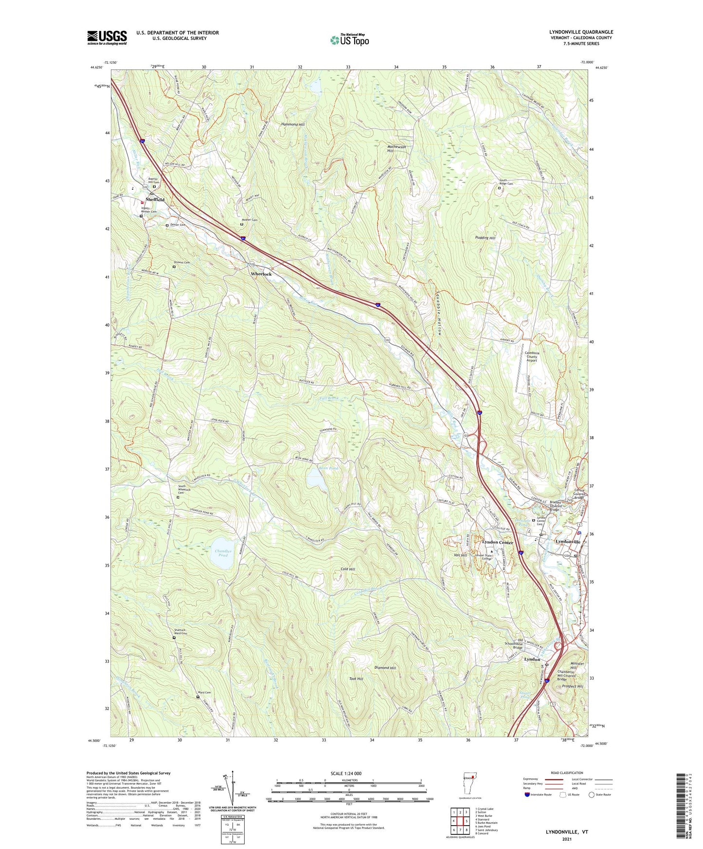
2024 topographic map quadrangle Lyndonville in the state of Vermont. Scale: 1:24000. Based on the newly updated USGS 7.5' US Topo map series, this map is in the following counties: Caledonia. The map contains contour data, water features, and other items you are used to seeing on USGS maps, but also has updated roads and other features. This is the next generation of topographic maps. Printed on high-quality waterproof paper with UV fade-resistant inks.
Quads adjacent to this one:
West: Stannard
Northwest: Crystal Lake
North: Sutton
Northeast: West Burke
East: Burke Mountain
Southeast: Concord
South: Saint Johnsbury
Southwest: Joes Pond
This map covers the same area as the classic USGS quad with code o44072e1.
Contains the following named places: Baptist Hill Cemetery, Bean Pond, Bradley Covered Bridge, Cableigh Public Library, Caledonia County Airport, Centre Covered Bridge, Chamberlain Brook, Chamberlin Mill Covered Bridge, Chandler Pond, Chandler Pond Dam, Chandler School, Cold Hill, Cold Hill Brook, Cornerstone Christian School, Dexter Cemetery, Diamond Hill, Drowns Cemetery, Fall Brook, Fenton Chester Ice Area, Hammond Hill, Ingalls - Mosher Cemetery, Institute Pond, Institute Pond Dam, Lyndon, Lyndon Area Chamber of Commerce, Lyndon Census Designated Place, Lyndon Center, Lyndon Center Cemetery, Lyndon Center Census Designated Place, Lyndon Center Post Office, Lyndon Educational Alternative Resources Network, Lyndon Institute, Lyndon Municipal Forest, Lyndon Post Office, Lyndon Rescue Incorporated, Lyndon State College, Lyndon Town Hall, Lyndonville, Lyndonville Fire Department, Lyndonville Post Office, Lyndonville United Methodist Church, Mathewson Brook, Mathewson Hill, Mathewson State Forest, Miller Run, Millers Run School, Minister Hill, Mosher Cemetery, Old Red School, Old Schoolhouse Bridge, Oregon Brook, Powers Park, Prospect Hill, Pudding Hill, Pudding Hill School, Ramsey Corner, Saint Peters Episcopal Church, Shattuck - Ward Cemetery, Sheffield, Sheffield - Wheelock Fire Department, Sheffield Census Designated Place, Sheffield Post Office, Shores Memorial Museum, South Ridge Cemetery, South Wheelock Branch, South Wheelock Cemetery, South Wheelock Church, Squabble Hollow, Squabble Hollow School, Square Brook, Stuart Pond, The Old Church on the Hill, Toot Hill, Town of Lyndon, Vail Hill, Village of Lyndonville, Ward Cemetery, Wheelock, WWLR-FM (Lyndonville), ZIP Codes: 05850, 05851