MyTopo
Saint Johnsbury Vermont US Topo Map
Couldn't load pickup availability
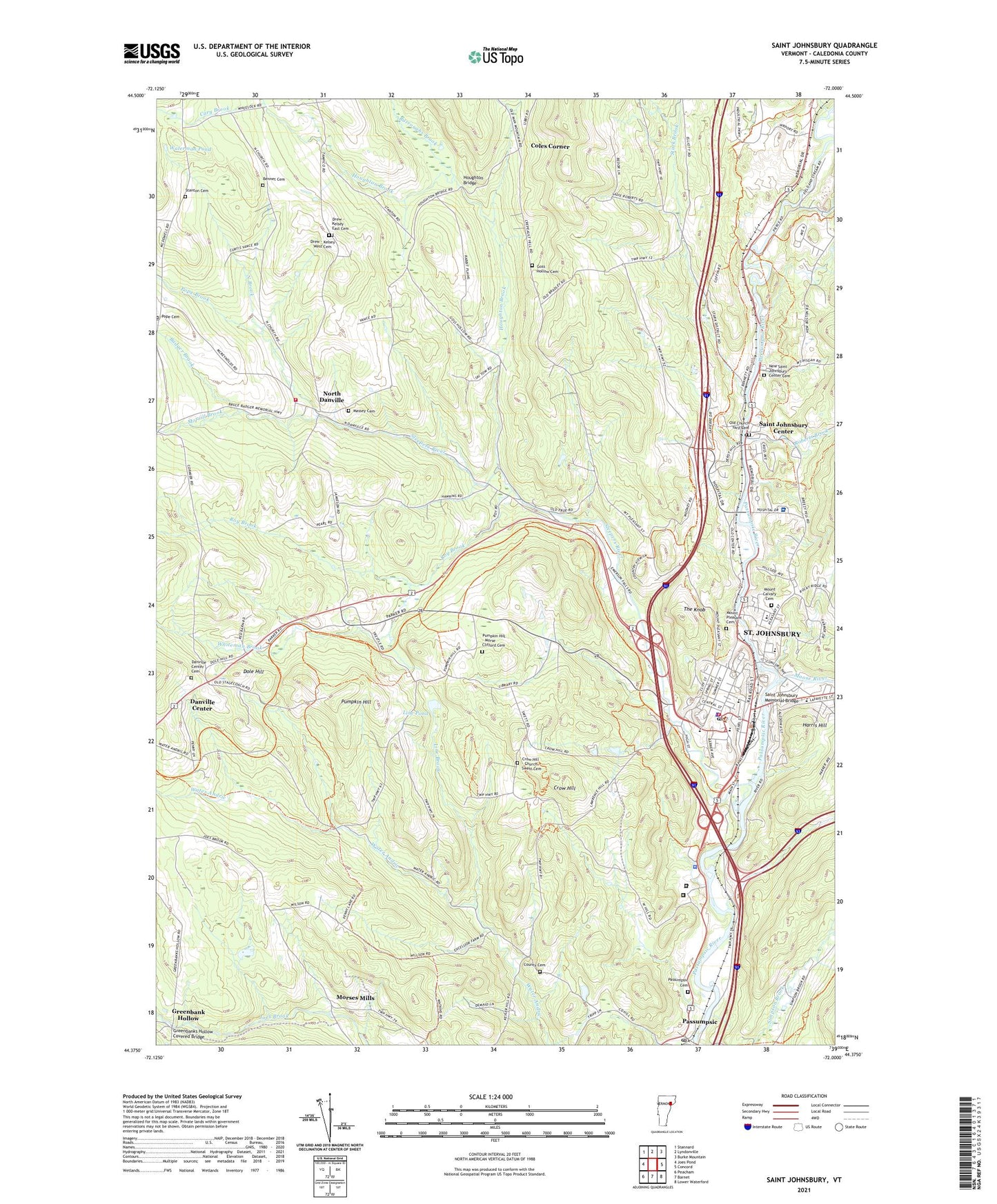
2024 topographic map quadrangle Saint Johnsbury in the state of Vermont. Scale: 1:24000. Based on the newly updated USGS 7.5' US Topo map series, this map is in the following counties: Caledonia. The map contains contour data, water features, and other items you are used to seeing on USGS maps, but also has updated roads and other features. This is the next generation of topographic maps. Printed on high-quality waterproof paper with UV fade-resistant inks.
Quads adjacent to this one:
West: Joes Pond
Northwest: Stannard
North: Lyndonville
Northeast: Burke Mountain
East: Concord
Southwest: Peacham
This map covers the same area as the classic USGS quad with code k44072d1.
Contains the following named places: Advent Christian Church, Arlington School, Arnold Falls Dam, Arnold Park, Arshla Dairy Farm, Badger Brook, Bennet Cemetery, Brown Brook, Burroughs Brook, Caledonia Community Work Camp - Saint Johnsbury, Caledonia County, Caledonia County Courthouse, Caledonia County Sheriff's Office, Caledonia School, Calex Ambulance Service, Cary Brook, Catamount Film and Arts Center, Church of the Messiah Universalist Church, Coles Corner, Cornerstone School, County Cemetery, Crow Hill, Crow Hill - Church - Swett Cemetery, Danville Center, Danville Center Cemetery, Danville Town Forest, Danville Volunteer Fire Department, Dole Hill, Drew - Kelsey East Cemetery, Drew - Kelsey West Cemetery, Fairbanks Museum and Planetarium Library, Fairbanks Museum and Plantarium, Fieroe Mill School, First Church of Christ Scientist, First Congregational Church, Four Corners School, Frank Adams School, Fuller Hall, Gage Dam, Goes Hollow School, Good Shepherd Catholic School, Goss Hollow Cemetery, Grace United Methodist Church, Green Mountain Mall Shopping Center, Greenbank Hollow, Greenbanks Hollow Covered Bridge, Harris Hill, Houghton Bridge, Houghton Brook, Kiwanis Pool and Tennis Courts, Lincoln Street School, Line Brook, Line Pond, Living Water Assembly of God Church, Massey Cemetery, Moose River, Morrill Brook, Morrill School, Morses Mills, Mount Calvary Cemetery, Mount Pleasant Cemetery, New Saint Johnsbury Center Cemetery, North Brook, North Church, North Congregational Church, North Danville, Northeast Kingdom Mental Health Center, Northeast Regional Correctional Complex - Saint Johnsbury, Northeastern Vermont Regional Hospital, Northeastern Vermont Regional Hosptial Information Center, Old Church Yard Cemetery, Passumpsic, Passumpsic Cemetery, Passumpsic Dam, Passumpsic Post Office, Pierce Mills Dam, Pleasant Street Baptist Church, Pope Brook, Pope Cemetery, Portland Street School, Pumpkin Hill, Pumpkin Hill - Morse Clifford Cemetery, Pumpkin Hill School, Railroad Street Historic District, Roberts Brook, Roy Brook, Saint Andrews Episcopal Church, Saint Johns Catholic Church, Saint Johnsbury, Saint Johnsbury Academy, Saint Johnsbury Athenaeum, Saint Johnsbury Census Designated Place, Saint Johnsbury Center, Saint Johnsbury Center Post Office, Saint Johnsbury Chamber of Commerce, Saint Johnsbury Country Club, Saint Johnsbury Fire Department, Saint Johnsbury Fire Station, Saint Johnsbury Historic District, Saint Johnsbury Main Street Historic District, Saint Johnsbury Memorial Bridge, Saint Johnsbury Middle School, Saint Johnsbury Municipal Forest, Saint Johnsbury Police Department, Saint Johnsbury Post Office, Saint Johnsbury School, Saint Johnsbury School District, Saint Johnsbury Seventh Day Adventist Elementary School, Saint Johnsbury Town Offices, Seventh Day Adventist Church, Sleepers River, South Congregational Church, Stanton Cemetery, Stanton School, Stark Brook, Stark School, Sumner Street School, Tampico School, The Knob, Town of Saint Johnsbury, Union Baptist Christian School, Union Baptist Church, Vermont State Police Troop A Saint Johnsbury Barracks, Waterman Pond, Whiteman Brook, ZIP Code: 05828