MyTopo
North Hartland Vermont US Topo Map
Couldn't load pickup availability
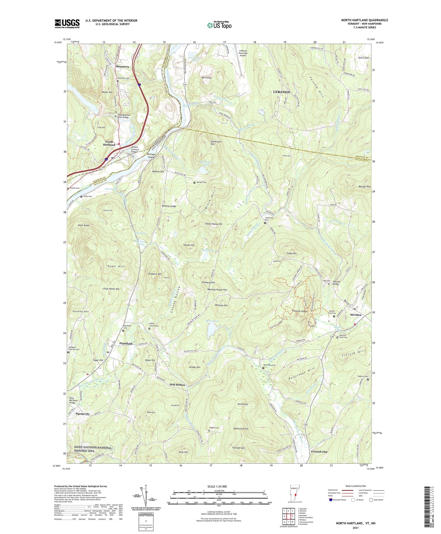
2024 topographic map quadrangle North Hartland in the states of New Hampshire, Vermont. Scale: 1:24000. Based on the newly updated USGS 7.5' US Topo map series, this map is in the following counties: Windsor, Sullivan, Grafton. The map contains contour data, water features, and other items you are used to seeing on USGS maps, but also has updated roads and other features. This is the next generation of topographic maps. Printed on high-quality waterproof paper with UV fade-resistant inks.
Quads adjacent to this one:
West: Hartland
Northwest: Quechee
North: Hanover
Northeast: Enfield
East: North Grantham
Southeast: Grantham
South: Claremont North
Southwest: Windsor
This map covers the same area as the classic USGS quad with code o43072e3.
Contains the following named places: Air-Wood Heliport, Altai Hill, Barnes Library, Barrett Four Corners, Beauty Hill, Beaver Brook, Black Hill, Bloods Brook, Blow-Me-Down Bridge, Bryant Brook, Bryant Pond, Burnaps Island, Burr Brook, Clay Brook, Clay Hill, Colby Cemetery, Colby Hill, Cole Brook, Cooney Hollow, Coreyville Cemetery, Cotton Hill, Cranberry Pond, Daniels Brook, Daniels Cemetery, Farnum Hill, Fernald Hill, Fifield Hill, Frenchs Ledge, Frog Hollow, Gallup Cemetery, Gilkey Cemeteries, Governors Hill, Hanchetts Brook, Hartland Volunteer Fire Department Station 2, Hell Hollow, Hibbard Brook, Hilliard Brook, Home Hill, Hopkins Cemetery, Howe Hill, Huggin Cemetery, Johnston Island, Jordan Hill, Jug Hill, Kenyon Hill, Kimball Union Academy, Ladieu Hill, Lewis Swale, Little Home Hill, Martin Brook, Meeting House Hill, Meridan Post Office, Meriden, Meriden Bridge, Meriden Fire Department, Mill Cemetery, Mill Hollow, Mill Village, Miller Hill, Moses Pond, Moulton-Yard Cemetery, Mount Finish, Mud Pond, Newton Brook, North Hartland, North Hartland Census Designated Place, North Hartland Community Church, North Hartland Dam, North Hartland Dam Recreation Area, North Hartland Post Office, Ottauquechee River, Ottauquechee River Bridge, Penniman Brook, Penniman Cemetery, Penniman Hill, Pinnacle Hill, Plainfield, Plainfield Cemetery, Plainfield Census Designated Place, Plainfield Community Baptist Church, Plainfield Elementary School, Plainfield Fire Department, Plainfield Police Department, Plainfield Post Office, Potato Hill, Poverty Lane Orchard, Pratts Corners, Prospect Hill, Puckerpod Swamp, Raynis-Ford Cemetery, Read Hill, Riverview Farm, Russtown, Russtown Cemetery, Shipman Brook, Short Knoll, Skinner Hill, Sky Ranch Pond, Smith Hill, Squag City, Stevens Hill, Stockwell Brook, Stone House Hill, Storrs Hill, Storrs Pond, Storrs Pond Dam, Sugar Hill, Town of Plainfield, Westgate-Peterson Cemetery, Whitney Hill, Willard Covered Bridge, Willard Ledge, Wine Brook, WNHV-AM (White River Junction), Yatsevitch Hill, ZIP Codes: 03770, 03781, 05052