MyTopo
Hanover New Hampshire US Topo Map
Couldn't load pickup availability
Also explore the Hanover Forest Service Topo of this same quad for updated USFS data
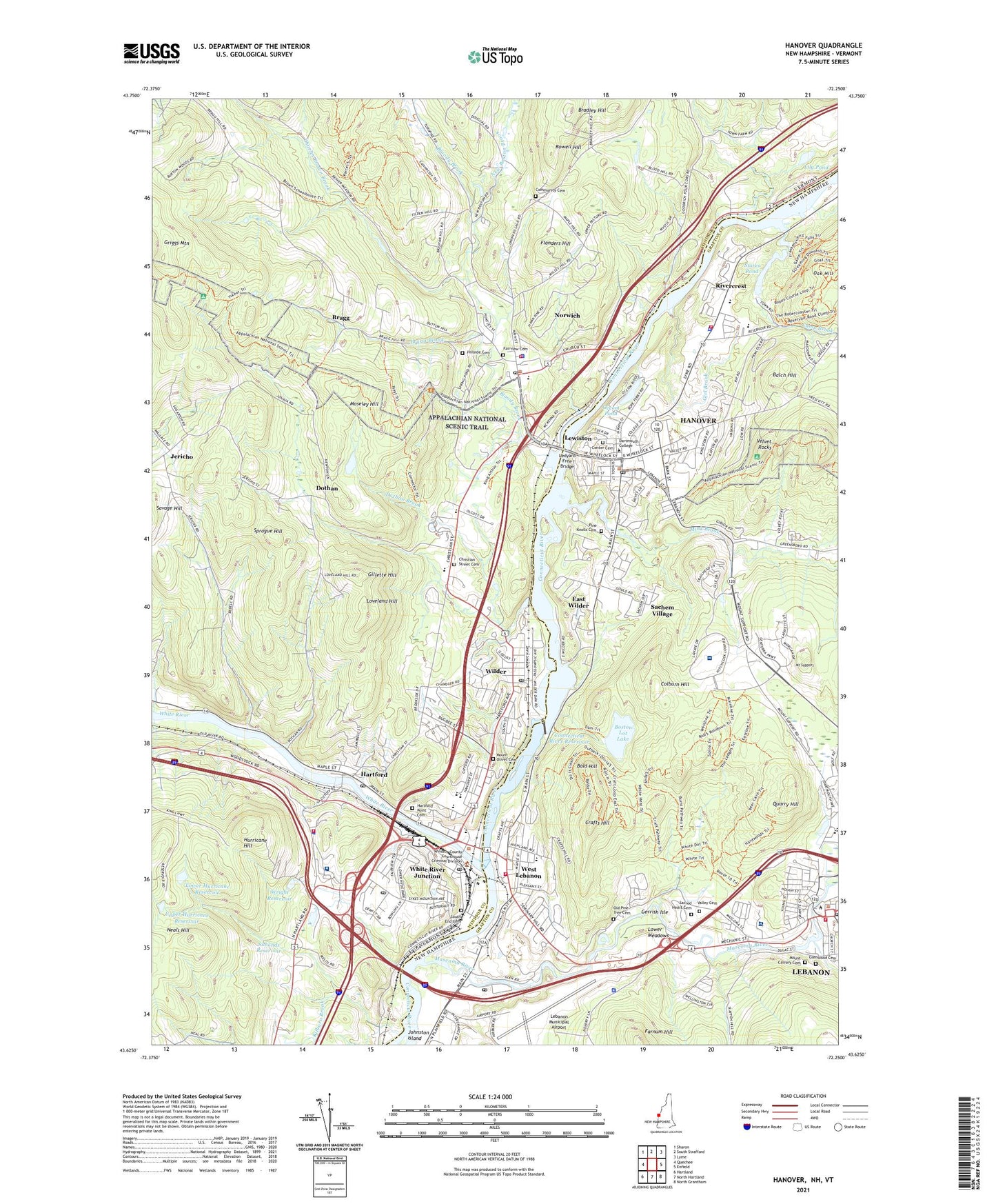
2024 topographic map quadrangle Hanover in the states of Vermont, New Hampshire. Scale: 1:24000. Based on the newly updated USGS 7.5' US Topo map series, this map is in the following counties: Grafton, Windsor. The map contains contour data, water features, and other items you are used to seeing on USGS maps, but also has updated roads and other features. This is the next generation of topographic maps. Printed on high-quality waterproof paper with UV fade-resistant inks.
Quads adjacent to this one:
West: Quechee
Northwest: Sharon
North: South Strafford
Northeast: Lyme
East: Enfield
Southeast: North Grantham
Southwest: Hartland
Contains the following named places: Alice Peck Day Memorial Hospital, Amos Tuck School of Administration and Finance, Aquinas House, Baker Memorial Library, Balch Hill, Bald Hill, Bartlett Tower, Bernice A Ray School, Berry Sports Center, Bissell Hall, Bloody Brook, Boston Lot Lake, Boston Lot Lake Dam, Bradley Center, Bradley Hill, Bragg, Bragg Brook, Brown Hall, Buchanan Hall, Bugbee Building Senior Center, Butterfield Hall, Byrne Hall, Camp Brook, Carpenter Hall, Carter Country Club, Carter-Witherell Building, Center Cemetery, Centerra Business Park, Channing Cox Hall, Charles Brown Brook, Chase Hall, Choate House, Choats Residence, Christian Street Cemetery, City of Lebanon, Colburn Hill, Colburn Park Historic District, College Green, College Hall, College Park, Community Cemetery, Connecticut River Reservoir, Conrad Antique Mall Shopping Center, Cook Auditorium, Courtyard Pavilion, Cradle and Crayon Child Development Center, Crafts Hill, Cumalings Hall, Cummings Dam, Cutters Shabazz Building, Dartmouth - Hitchcock Medical Center, Dartmouth College, Dartmouth Hall, Dartmouth Outing Club House, Dartmouth Outing Club Trail, Davis Field House, Department of Veterans Affairs Medical Library, Dothan, Dothan Brook, Dothan Brook School, Dragon Hall, East Wilder, Estabrook School, Fairview Cemetery, Feldburg Library, Filene Auditorium, Flanders Hill, Frances C Richmond Middle School, French Hall, Friends of Dartmouth Flowing Boathouse, Frost Park, Fuller Boathouse, Gerrish Isle, Gerry Hall, Gile Hall, Gillette Hill, Girl Brook, Glen Road Plaza Shopping Center, Glenwood Cemetery, Great Brook, Griggs Mountain, Hannahs Mobile Home Park, Hanover, Hanover Area Chamber of Commerce, Hanover Census Designated Place, Hanover Country Club, Hanover High School, Hanover Historical Society Building, Hanover Police Department, Hanover Post Office, Hanover Street School, Hanover Town Offices, Happy Hill Cabin, Hartford, Hartford Area Career and Technical Center, Hartford Fire Department Station 1 Headquarters, Hartford High School, Hartford Memorial Middle School, Hartford Municipal Building, Hartford Point Cemetery, Hartford Police Department, Hartford Post Office, Hartford Public Library, Hartford School District Office, Hartford Village Census Designated Place, Hillside Cemetery, Himan Hall, Hopkins Center, Howe Library, Hurricane Hill, Jericho, Kade German Center, Kilburn Brook, Klewh Computation Center, Lebanon, Lebanon City Hall and Opera House, Lebanon College, Lebanon Municipal Airport, Lebanon Post Office, Lebanon Public Library, Ledyard Canoe Club, Ledyard Free Bridge, Leverone Field House, Lewiston, Lily Pond, Little Hall, Lord Hall, Loveland Hill, Lower Hurricane Reservoir, Lower Hurricane Reservoir Dam, Lower Meadows, Lyman Post Office, Maple Leaf Campground, Marion W Cross School, Mascoma River, Mascoma River Dam, Mascoma River Dam Number 2, Mascoma River Dam Number 3, Massachusetts Hall, Maxwell Hall, McLane Hall, Meadow Brook Village, Memorial Park, Mink Brook, Montessori Discovery School, Montshire Museum, Montshire Nature Trails, Moseley Hill, Mount Calvary Cemetery, Mount Lebanon Elementary School, Mount Olivet Cemetery, Mount Support, Murdough Center, Neals Hill, New Boston Brook, New Life Christian Academy, Newton Cabin, North Country Plaza Shopping Center, North Fairbanks Hall, Norwich, Norwich Census Designated Place, Norwich Fire Department, Norwich Green, Norwich Historical Society Building, Norwich Police Department, Norwich Post Office, Norwich Village Historic District, Oak Hill, Occom Pond, Occom Ski and Skate Center, Olcot Falls Mobile Home Park, Old Kings Highway, Old Pine Tree Cemetery, Oscars Mobile Home Park, Parkhurst Hall, Pine Knolls Cemetery, Pinewood Village, Plant Number 1 Dam, Potter's House School, Powerhouse Shopping Mall Shopping Center, Quarry Hill, River City Arts and White River Theater, Rivercrest, Robinson Hall, Rockefellar Center, Rowell Hill, Russell Sage Hall, Sachem Village, Sacred Heart Cemetery, Sacred Heart Public School, Sanborn English House, School Street School, Seminary Hill School, Shattuck Observatory, Silsby Hall, Simonds Reservoir, South End Cemetery, Sprague Hill, Storrs Hill Ski Area, Storrs Pond, Storrs Pond Recreation Area, The Galleria Shopping Center, The Mall, Tuck Mall, Upper Hurricane Reservoir, Upper Valley Plaza Shopping Center, Valley Cemetery, Velvet Rocks, Vermont District Courthouse, Veterans Adminstration Medical and Regional Office Center, WDCR-AM (Hanover), West Lebanon, West Lebanon Plaza Shopping Center, West Lebanon Post Office, WFRD-FM (Hanover), White River, White River Junction, White River Junction Census Designated Place, White River Junction Chamber of Commerce, White River Junction Historic District, White River Junction Post Office, White River Junction Veterans Affairs Medical Center, White River School, Wilder, Wilder Census Designated Place, Wilder Dam, Wilder Dam Fish Ladder, Wilder Dam Information Center, Wilder Post Office, Willow School, Wright Reservoir, Wright Reservoir Dam, WTSL-AM (Hanover), WTSL-FM (Hanover), ZIP Code: 03784