MyTopo
Springfield Vermont US Topo Map
Couldn't load pickup availability
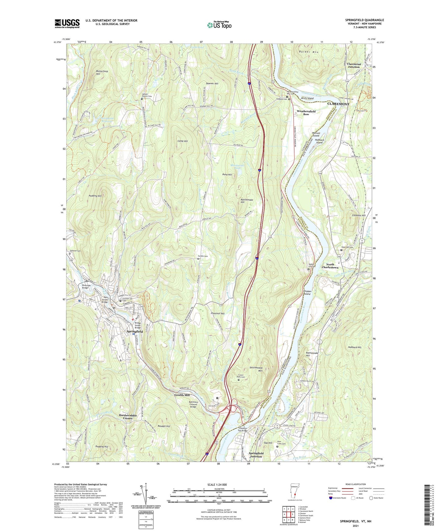
2021 topographic map quadrangle Springfield in the states of New Hampshire, Vermont. Scale: 1:24000. Based on the newly updated USGS 7.5' US Topo map series, this map is in the following counties: Windsor, Sullivan. The map contains contour data, water features, and other items you are used to seeing on USGS maps, but also has updated roads and other features. This is the next generation of topographic maps. Printed on high-quality waterproof paper with UV fade-resistant inks.
Quads adjacent to this one:
West: Chester
Northwest: Cavendish
North: Windsor
Northeast: Claremont North
East: Claremont South
Southeast: Alstead
Southwest: Saxtons River
Contains the following named places: Baltimore Covered Bridge, Barkmill Brook, Beaver Brook, Black River, Black River Falls, Blood Brook, Bloodsucker Pond, Bow Church, Bridge Street Bridge, Butterfield Hill, Calavant Hill, Calvary Baptist Church, Camp Hill, Charlestown Ambulance Service, Cheshire Toll Bridge, Chestnut Hill, Claremont Industrial Park, Claremont Junction, Community College of Vermont, Crown Point Cemetery, Crown Point Country Club, Downer Hill, East School, Elm Hill School, Eureka Cemetery, Eureka Schoolhouse, Fellows Dam, First Congregational Church, Freedom Park, Gateway School, Glidden Island, Goulds Mill, Gully Brook, Hackett Brook, Hardscrabble Corner, Hartness House and Hartness Porter Museum, Holy Family Catholic School, Holy Trinity Othodox Church, Hope Hill Cemetery, Hoyts Landing, Hubbard Cemetery, Hubbard Hill, Hubbard Hill State Forest, Hubbard Island, Jarvis Island, Little Sugar River, Meadow Brook, North Branch Black River, North Charlestown, North Charlestown Community School, Oak Hill, Oakland Cemetery, One Hundred River Street Complex Shopping Center, Ox Brook, Park Farm School, Park Street Bridge, Park Street School, Pine Crest Cemetery, Pond Hill, Pudding Hill, Randall Hill, Rattlesnake Hill, River Valley Technical Center, Riverside Bridge, Riverside Middle School, Riverside Park, Saint Lukes Episcopal Church, Saint Marks Episcopal Church, Saint Marys Catholic Church, Seavers Brook, Skitchewaug Mountain, Skitchewaug State Wildlife Management Area, Southern State Correctional Facility - Springfield, Southern Vermont Education Center, Spencer Brook, Springfield, Springfield Assembly of God Church, Springfield Census Designated Place, Springfield Chamber of Commerce, Springfield Downtown Historic District, Springfield Fire Department, Springfield High School, Springfield Hospital, Springfield Hospital Information Center Library, Springfield Junction, Springfield Police Department, Springfield Pool, Springfield Post Office, Springfield Reservoir, Springfield Reservoir Dam, Springfield Shopping Plaza Shopping Center, Springfield Supervisory Union, Springfield Town Forest, Springfield Town Library, Springfield Town Offices, Springfield United Methodist Church, State Fish and Wildlife Management Area, Summer Hill Cemetery, The Commons Park, The Farm Campground, Town of Springfield, Union Street School, Unitarian Universalist Church, Upham-Aldrich Cemetery, Walcott Island, Walker-Gill Cemetery, WCFR-AM (Springfield), Weathersfield Bow, Weathersfield Bow Cemetery, WMKS-FM (Springfield), YMCA Meeting Waters Day Camp, ZIP Code: 05156