MyTopo
Dutch Gap Virginia US Topo Map
Couldn't load pickup availability
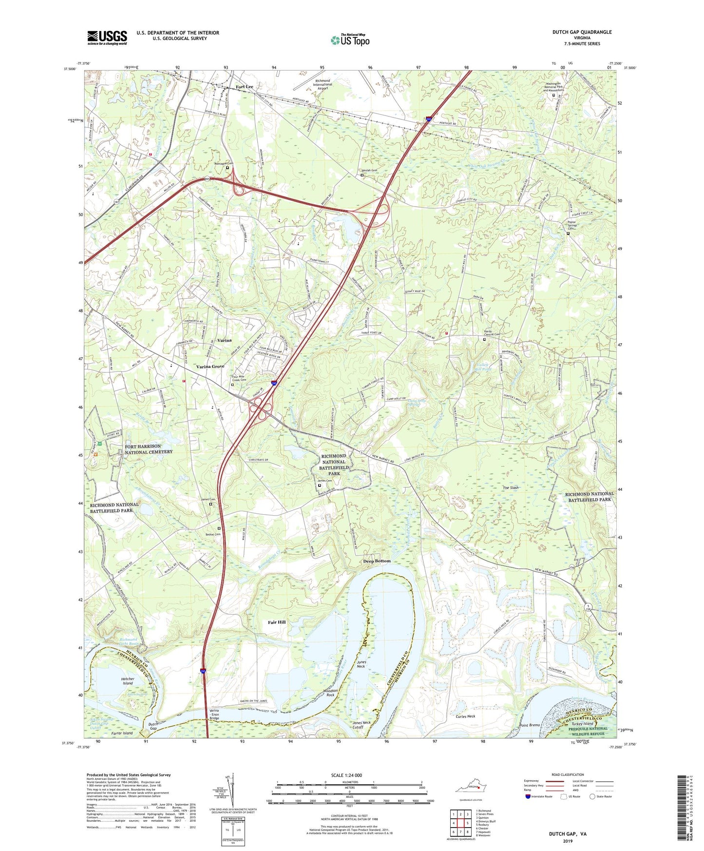
2019 topographic map quadrangle Dutch Gap in the state of Virginia. Scale: 1:24000. Based on the newly updated USGS 7.5' US Topo map series, this map is in the following counties: Henrico, Chesterfield, Charles City. The map contains contour data, water features, and other items you are used to seeing on USGS maps, but also has updated roads and other features. This is the next generation of topographic maps. Printed on high-quality waterproof paper with UV fade-resistant inks.
Quads adjacent to this one:
West: Drewrys Bluff
Northwest: Richmond
North: Seven Pines
Northeast: Quinton
East: Roxbury
Southeast: Westover
South: Hopewell
Southwest: Chester
Contains the following named places: Aiken House, Aiken Swamp, Aiken Swamp-Dutch Gap Cutoff, Bailey Creek, Baker Elementary School, Bennets Store, Bethel Church, Bethel School, Beulah Cemetery, Beulah Church, Camp Holly, Camp Holly Springs, Central School, Church of God, Cotman, Crewes Channel, Crewes House, Curles Neck Mansion Wharf, Curles Neck Plantation, Darbytown Estates, Darbytown Road Landfill, Deep Bottom, Deep Bottom Landing, Deep Bottom Park, Deep Run, Deerlick Branch, Dorey Park, Dutch Gap, East End Christian Academy, Eastgate Industrial Center, Fair Hill, First Bethel Baptist Church Cemetery, Fort Brady, Fort Harrison, Fort Harrison National Cemetery, Fort Lee, Four Mile Creek Cemetery, Four Mile Creek Park, Fourmile Creek, Fourmile Creek Church, George F Baker Elementary School, Good Neighbor Village Assisted Living Facility, Gravel Hill Church, Gravel Hill School, Griggs Dam, Griggs Pond, Hardy Central Cemetery, Hardy Central Church, Hatcher Island, Henrico Central School, Henrico County, Henrico County Fire Station 2, Henrico County Firehouse 18, Henrico County Firehouse 4, Henricopolis, Henricus Park, James Cemetery, John Rolfe Middle School, Jones Neck, Jones Neck Cutoff, Jonesboro School, Kingdom Preparatory Academy, Malvern Hill Battlefield, Mehfoud Elementary School, Montague Cemetery, Picketts Wharf, Pioneer Church, Point Bremo, Poplar Springs, Poplar Springs Cemetery, Poplar Springs Church, Reedy Branch, Richmond Dragway, Richmond Yacht Basin, Ross Run, Roundabout Creek, Saint James Church, Saint James School, Second Bethel Church, Star of Bethlehem Church, Sweeney Creek, The Slash, Tilmans Wharf, Turner Woods, Union Grove Chapel, Valley Mill Pond, Varina, Varina - Enon Bridge, Varina Baptist Church, Varina Branch Henrico County Public Library, Varina District, Varina Elementary School, Varina Episcopal Church, Varina Farm, Varina Gardens, Varina Grove, Varina Meadows, Varina Place, Ward Elementary School, Washington Memorial Park and Mausoleums, White Oak Swamp Creek, Whitlock Estates, Williamson Farms, Woodson Rock, WRVA-AM (Richmond), WRVQ-FM (Richmond), Yahley Mills Estates, ZIP Code: 23231