MyTopo
Drewrys Bluff Virginia US Topo Map
Couldn't load pickup availability
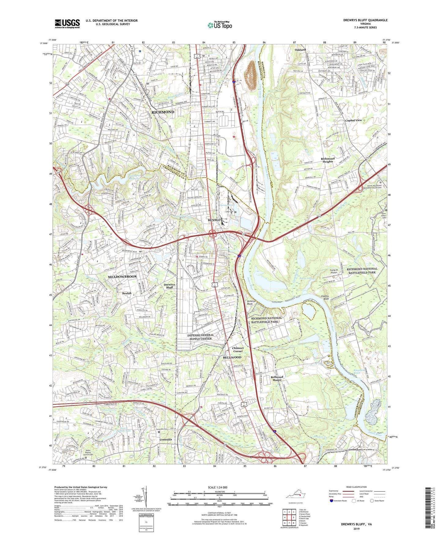
2022 topographic map quadrangle Drewrys Bluff in the state of Virginia. Scale: 1:24000. Based on the newly updated USGS 7.5' US Topo map series, this map is in the following counties: Chesterfield, Henrico, Richmond (city). The map contains contour data, water features, and other items you are used to seeing on USGS maps, but also has updated roads and other features. This is the next generation of topographic maps. Printed on high-quality waterproof paper with UV fade-resistant inks.
Quads adjacent to this one:
West: Chesterfield
Northwest: Bon Air
North: Richmond
Northeast: Seven Pines
East: Dutch Gap
Southeast: Hopewell
South: Chester
Southwest: Beach
This map covers the same area as the classic USGS quad with code o37077d4.
Contains the following named places: Afton, All Saints Apostolic Church, All Saints Letsy Ann Memorial School, Ampt Hill, Ampthill Heights, Ampthill Post Office, Antioch Baptist Church, Antioch Church, Banton Street Pentecostal Holiness Church, Battery Maury, Bellmeade, Bellwood, Bellwood Baptist Church, Bellwood Census Designated Place, Bellwood Elementary School, Bellwood Estates, Bellwood Manor, Bellwood Pentecostal Holiness Church, Bellwood Terrace, Belmont United Methodist Church, Bensley, Bensley - Bermuda Volunteer Rescue Squad North Station, Bensley Census Designated Place, Bensley Elementary School, Bensley Park, Bensley Station Number 3, Bensley Village, Beulah, Beulah Elementary School, Beulah United Methodist Church, Beulah Village, Bird Athletic Complex, Bird Park, Branch Church, Branches Shopping Center, Brentwood, Brittonwood, Broad Rock, Broad Rock Branch Richmond Public Library, Broad Rock Church, Broad Rock Creek, Broad Rock Elementary School, Broad Rock Manor, Brookbury, Capitol View, Cary Cemetery, Cedar Farms, Central Park, Centralia, Centralia Cemetery, Centralia Gardens, Centralia Presbyterian Church, Centralia Station Number 17, Chaffin Bluff, Cherry Gardens, Chesswood, Chesterfield Career and Technical Center at Courthouse, Chesterfield Court, Chesterfield Fire and Emergency Medical Services Station 11 Dale, Chesterfield Fire and Emergency Medical Services Station 17 Centralia, Chesterfield Fire and Emergency Medical Services Station 3 Bensley, Chesterfield Juvenile Detention Center, Chimney Corner, Chippendale Retirement Center, Clopton, Coles Run, Cornelius Creek, Cosby Memorial Church, Courthouse Green, Covenant Faith Church, Crescent Park, Crooked Branch, Deepwater Terminal Port of Richmond, Defense Supply Center Fire Station Richmond, Defense Supply Center Richmond, Dorchester, Drewrys Bluff, Drewrys Bluff Church, E I Dupont Medical Emergency Response Team Ambulance, E S H Greene Elementary School, Eaves Lake, Ebenezer Church, Faith Gospel Temple Church of God in Christ, Falling Creek, Falling Creek Elementary School, Falling Creek Filtration Plant Dam, Falling Creek Middle School, Falling Creek Reservoir, Felipos Mobile Court, Fellowship Church, First Baptist Church, Flying W Airport, Fort Alexander, Fort Beauregard, Fort Darling, Fort Gilmer, Fort Gregg, Fort Hoke, Fort Johnson, Full Gospel Tabernacle Church, Goode Creek, Great Branch, Greater Ebenezer African Methodist Episcopal Church, Grindall Creek, Hickory Hill School, Holiday Park Trailer Park, Hopkins Road Elementary School, Howlett Park, Hunter Holmes McGuire Veterans Affairs Medical Center Richmond, Hunting Creek Hills, Immanuel Pentecostal Church, Indian Springs, Iron Bridge Park, Irongate Village Shopping Center, J G Hening Elementary School, J L Francis Elementary School, Jean Court, Kendale, Kimberly Acres, Kingsland Acres, Kingsland Baptist Church, Kingsland Christian School, Kingsland Creek, Kingsland Reach, Kinsland Creek, Lake Ely, Laurel Hill Church, Laurel Hill United Methodist Church Cemetery, Lloyd C Bird High School, Lost Forest, Manchester Baptist Church, McGuire Virginia Medical Center Heliport, Meade Landing, Meadowbrook, Meadowbrook Census Designated Place, Meadowbrook Country Club, Meadowbrook High School, Meadowbrook Plaza Shopping Center, Meadowdale Shopping Center, Mill Creek, Mount Olive Baptist Church, Mount Zion Holy Church, New Covenant Presbyterian Church, New Life Baptist Church, Oak Grove Baptist Church, Oakland, Oakland Church, Old Lane Cemetery, Old Stone Bridge, Parnell Air Industrial Park, Patromdale, Pebble Spring, Perrymont Middle School, Phillip Morris Emergency Response Team, Piney Knolls, Pocoshock Creek, Polishing Dam, Polishing Pond, Preschool Academy, Proctors Creek, Quail Oaks, Redwater Creek, Reedy Creek, Richmond Fire Department Station 21, Richmond Fire Department Station 22, Richmond Heights, Richmond Public Library Meadowdale Branch Library, Ruffin Road Elementary School, Saint James Cemetery, Sale Station Number 11, Salem Baptist Church Cemetery, Salem Church, Salem Church Elementary School, Salem Church Middle School, Salem Woods, Salem Woods Dam, Salem Woods Lake, Scottdale, South Garden, Southside Baptist Temple, Southside Church, Southside Post Office, Southside Station Richmond Post Office, Spray Dam, Spray Pond, Stockton Memorial Baptist Church, Summer Hill - Ruffin Road Elementary School, The First Tee Chesterfield Golf Course, The Mews, Thomas C Boushall Middle School, Tidewater Quarries, Varina High School, Walmsley Village, Warwick, Warwick Mobile Home Park, Warwick Plaza Shopping Center, Watch Run, WDYL-FM (Chester), Webber Community Christian School, WGGM-AM (Chester), White Battery, WKHK-FM (Colonial Heights), WLEE-AM (Richmond), Worsham Trailer Park, ZIP Codes: 23224, 23234, 23237