MyTopo
Richmond Virginia US Topo Map
Couldn't load pickup availability
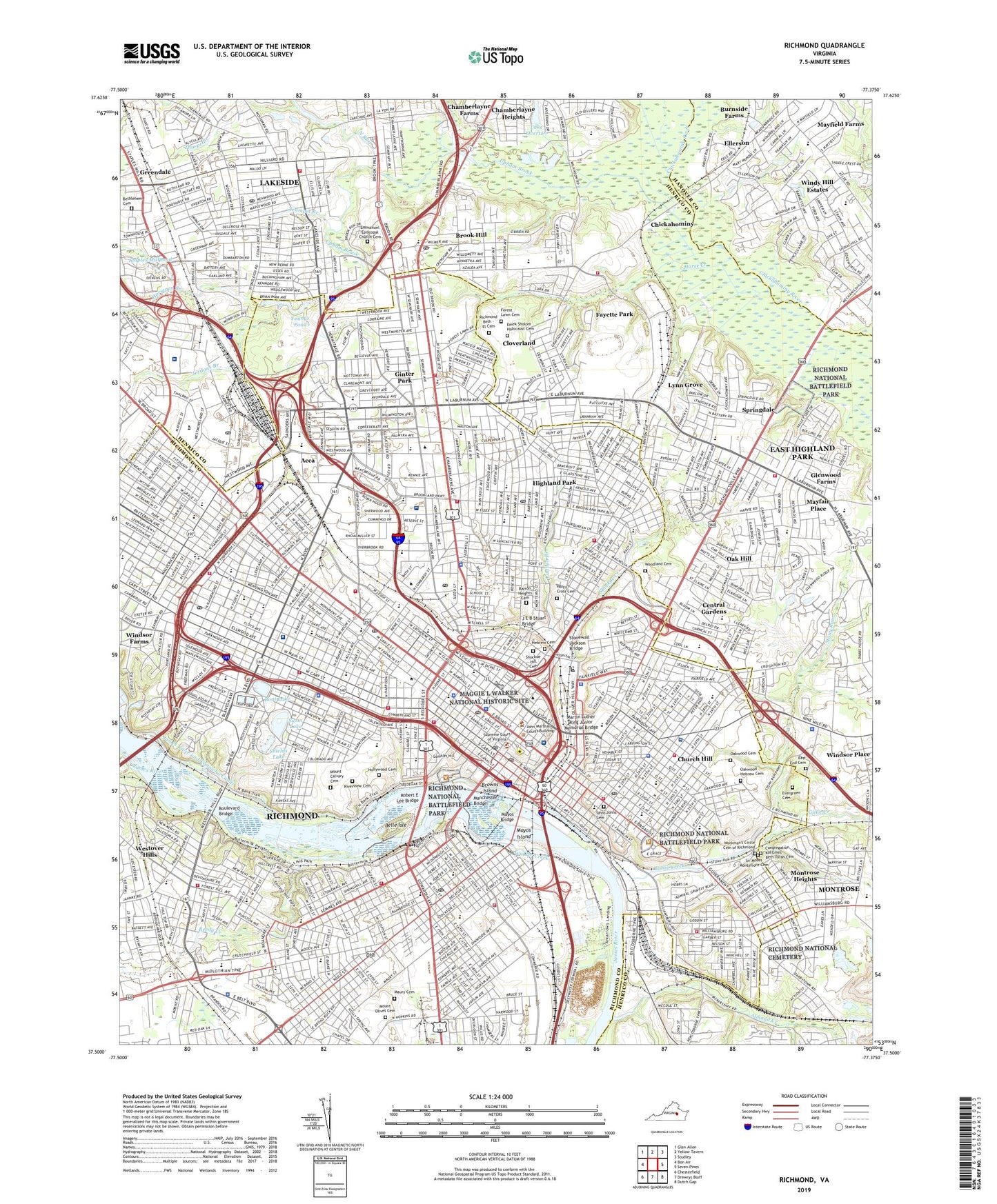
2022 topographic map quadrangle Richmond in the state of Virginia. Scale: 1:24000. Based on the newly updated USGS 7.5' US Topo map series, this map is in the following counties: Richmond (city), Henrico, Hanover. The map contains contour data, water features, and other items you are used to seeing on USGS maps, but also has updated roads and other features. This is the next generation of topographic maps. Printed on high-quality waterproof paper with UV fade-resistant inks.
Quads adjacent to this one:
West: Bon Air
Northwest: Glen Allen
North: Yellow Tavern
Northeast: Studley
East: Seven Pines
Southeast: Dutch Gap
South: Drewrys Bluff
Southwest: Chesterfield
This map covers the same area as the classic USGS quad with code o37077e4.
Contains the following named places: Abner Clay Park, Acca, Almond Creek, Arthur Ashe Junior Athletic Center, Azalea Plaza Shopping Center, Bacons Quarter Branch, Barton Heights Cemetery, Battery Park, Bear Creek Dam, Bell Tower, Belle Island Prisoner of War Camp, Belle Isle, Belmont Park, Bethlehem Cemetery, Boat Lake, Bojangles Statue, Boulevard Bridge, Boulevard Historic District, Broad Street Station, Brook Hill, Brook Hill Azalea Shopping Center, Brown Island Park, Browns Island, Browns Island Heliport, Byrd Park Canal Dam, Byron Highland Park Plaza, Ca Ira Dam, Camp Lee, Cannon Branch, Capitol Square, Carneals Store, Carter Jones Park, Central Gardens, Chestnut Hill, Chickahominy, Chickahominy Bluffs, Children's Hospital of Richmond - Brook Road Campus, Chimborazo Park, Church Hill, Circle Shopping Center, City of Richmond, City of Richmond SouthsideTransfer Station, Clarke Springs Park, Cloverland, Commodore Matthew Fontaine Maury Monument, Commonwealth Club Historic District, Confederate Armory, Confederate Navy Yard, Confederate Soldiers and Sailors Monument, Congregation Kol Emes Beth Torah Cemetery, Crossroads Shopping Center, Dumbarton, Dumbarton Square Shopping Center, East End Cemetery, East Highland Park, East Highland Park Census Designated Place, Ellerson, Ellerson Industrial Park, Emek Sholom Holocaust Cemetery, Emmanuel Episcopal Church Cemetery, English Village Historic District, Evergreen Cemetery, Fairfield District, Fan Area Historic District, Fayette Park, First Market, Flippen Creek, Ford Bridge, Forest Hill Park, Forest Lawn Cemetery, Fort West, Gambles Hill, General J E B Stuart Statue, George Washington Statue, Gillie Creek, Gimbles Hill Park, Ginter Park, Ginter Park Historic District, Glen Echo Lake, Glen Lea Shopping Center, Glenwood Farms, Glenwood Golf Club, Great Shiplock Park, Greendale, Hebrew Cemetery, Henrico Plaza Shopping Center, Hermitage Business Park, Hermitage Country Club, Highland Park, Highland Plaza, Holly Street Park, Hollywood Cemetery, Hollywood Power Plant Dam, Holy Cross Cemetery, Horse Creek, Horsepen Branch, Hotchkiss Park, Hovey Field, Hull Street Station, J E B Stuart Bridge, Jackson Ward Historic District, James River and Kanawha Canal Historic District, Jefferson Davis Monument, Jefferson Park, Jordans Branch, Joseph Byran Park, Kanawha Plaza, Kiehr Field, Lake Overton, Lakeside, Lakeside Census Designated Place, Lakeside Country Club, Lewis Ginter Botanical Gardens, Libby Terrace Park, Lower Rocketts, Lynn Grove, Maggie L Walker National Historic Site, Main Street Station, Main Street Station Shopping Center, Manchester, Manchester Bridge, Marion Hill, Martin Luther King Junior Memorial Bridge, Maury Cemetery, Mayfair Place, Mayfield Farms, Maymont Park, Mayos Bridge, Mayos Island, McGuire Circle, MCV Heliport, Meadowood Square Shopping Center, Medical College of Virginia Heliport, Memorial Medical Center, Mobile Towne Mobile Home Park, Monroe Park, Monroe Park Historic District, Montrose, Montrose Census Designated Place, Montrose Heights, Monument Avenue Historic District, Mount Calvary Cemetery, Mount Olivet Cemetery, North Run, Northeast Plaza Shopping Center, Oak Hill, Oakwood Cemetery, Oakwood Hebrew Cemetery, Old Dominion Landfill, Oregon Hill Historic District, Parker Field, Parker Field Annex, Patrick Henry Park, Pine Camp, Poe Shrine, Pollard Park, Powhatan Playground, Powhite Creek, Reedy Creek, Richmond, Richmond Beth - El Cemetery, Richmond City Canal, Richmond City Fairgrounds, Richmond Dueling Grounds, Richmond International Raceway, Richmond National Cemetery, Richmond Waterworks, Riverview Cemetery, Robert E Lee Bridge, Robert E Lee Statue, Rocketts Landing, Saint Johns Cemetery, Saint Johns Church Historic District, Saint Lukes Hospital, Shields Lake, Shockoe Creek, Shockoe Hill Cemetery, Shockoe Slip Historic District, Shockoe Warehouse District, Sir Moses Montefiore Cemetery, Sixth Street Marketplace, South Richmond, Southside Plaza Shopping Center, Springdale, Staples Mill Shopping Center, Staples Millpond, Stonewall Jackson Bridge, Stonewall Jackson Statue, Stony Run, Suburban Shopping Center, Swan Lake, Taylor Road Landfill, Taylors Hill Park, The Diamond, Thorpe Branch, Three Chopt Estate Dam, Three Lakes Park, Tredegar Iron Works, Trumpet Branch, Twentynine Hundred Block Grove Avenue Historic District, Two Hundred Block West Franklin Historic District, University Stadium, Upham Brook, Upper Sheilds Lake Dam, Vawter Street Park, Virginia State Fairgrounds, Walker Creek, WANT-AM (Richmond), Washington Park, Washington Square Park, WCVE-FM (Richmond), West Franklin Street Historic District, Westover Hills, WFTH-AM (Richmond), William Byrd Park, Willow Lawn Shopping Center, Windsor Farms, Windy Hill Estates, Woodland Cemetery, Woodland Park, Workman's Circle Cemetery of Richmond, World War II Memorial, WRBN-AM (Richmond), WTVR-AM (Richmond), WTVR-FM (Richmond), WTVR-TV (Richmond), Youngs Pond, Youngs Pond Dam, ZIP Codes: 23219, 23220, 23221, 23222, 23223, 23227, 23230