MyTopo
Chester Virginia US Topo Map
Couldn't load pickup availability
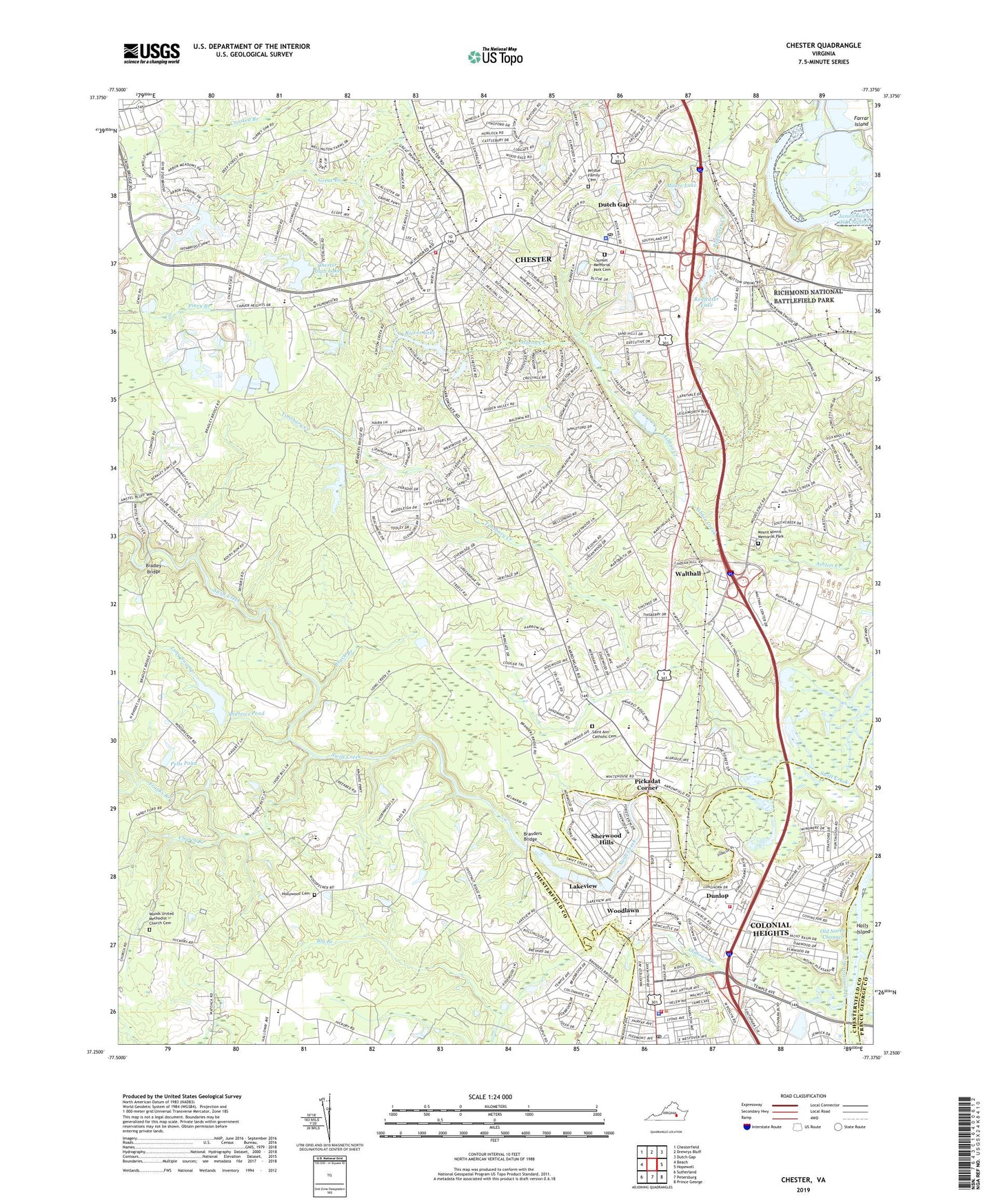
2022 topographic map quadrangle Chester in the state of Virginia. Scale: 1:24000. Based on the newly updated USGS 7.5' US Topo map series, this map is in the following counties: Chesterfield, Colonial Heights (city), Prince George. The map contains contour data, water features, and other items you are used to seeing on USGS maps, but also has updated roads and other features. This is the next generation of topographic maps. Printed on high-quality waterproof paper with UV fade-resistant inks.
Quads adjacent to this one:
West: Beach
Northwest: Chesterfield
North: Drewrys Bluff
Northeast: Dutch Gap
East: Hopewell
Southeast: Prince George
South: Petersburg
Southwest: Sutherland
This map covers the same area as the classic USGS quad with code o37077c4.
Contains the following named places: Andrews Dam, Andrews Pond, Appomattox Small Boat Harbor, Archer Bluff, Autumn Oaks, Beach Branch, Bensley - Bermuda Volunteer Rescue Squad Main Base, Bensley - Bermuda Volunteer Rescue Squad South Station, Bermuda Baptist Church, Bermuda District, Bermuda Elementary School, Bermuda Park Industrial Park, Bermuda Place, Bermuda Square Shopping Center, Bethesda Church, Big Branch, Boulevard Heights, Bradley Bridge, Braebrook Village, Branders Bridge, Breckenridge Shopping Center, Bryan Ridge, C C Wells Elementary School, C E Curtis Elementary School, Carver Homes, Centralia School, Chester, Chester Baptist Church, Chester Branch Chesterfield County Library, Chester Census Designated Place, Chester Club Dam, Chester Club Lake, Chester Golf Course, Chester Middle School, Chester Post Office, Chester United Methodist Church, Chesterbrook Farms, Chesterfield Community High School, Chesterfield County Police Department Chester Station, Chesterfield Fire and Emergency Medical Services Station 1 Chester, Chesterfield Fire and Emergency Medical Services Station 14 Dutch Gap, Church Branch, Church of the Nazarene, City of Colonial Heights, Colonial Heights Christian Church, Colonial Heights Emergency Medical Services, Colonial Heights Fire and Emergency Medical Services Department Administration, Colonial Heights Fire and Emergency Medical Services Station 1, Colonial Heights Fire and Emergency Medical Services Station 2, Colonial Heights Health Department, Colonial Heights High School, Colonial Heights Police Department, Colonial Heights Post Office, Colonial Heights Public Library, Colonial Heights Vocational-Technical School, Colonial Square Shopping Center, Columbia Park, Dunlop, Dutch Gap, Dutch Gap Station Number 14, Ecoff Elementary School, Edenshire, Faith Baptist Church, Fellowship Baptist Church, Fire Station Number 14 Heliport, Franks Branch, Gay Farms, George Carver Middle School, Glebe Point, Grace Lutheran Church, Greenbriar, Greenleigh Mobile Home Park, Greenwood Church, Grove Place, Harrowgate Baptist Church, Harrowgate Elementary School, Harrowgate Park, Hidden Valley Estates, Hollywood Cemetery, Hollywood Church, Iron Bridge Plaza Shopping Center, Ironbridge Baptist Church, Ivey Memorial Church, James River Old Channel, John Tyler Community College - Chester Campus, Kingdom Hall of Jehovahs Witnesses, Lake Neda Dam, Lake View Dam, Lake View Lake, Lakeview, Lakeview Elementary School, Lakewood Estates, Life Christian Academy, Locust Grove, Long Swamp, Lora Lynn Heights, Marguerite Christian Elementary School, Matoaca High School, Matoaca Park, Mistwood Forest, Moore Lake, Mount Minnis Memorial Park, Mount Pleasant Baptist Church, North Elementary School, Old North Channel, Oldtown Creek, Pells Dam, Pells Pond, Perdue Family Cemetery, Pickadat Corner, Pineland, Piney Branch School, Port Walthall School, Preston Place, Redwater Lake, Rieves Dam, Rieves Lake, Saint Ann Catholic Cemetery, Saint Johns Church, Saint Michaels Episcopal Church, Second Baptist Church, Shadowbrook Heights, Sherwood Hills, Shiloh Church, Somerset, Southpark Mall, Stafford Place, Sunset Memorial Park Cemetery, Swift Creek Baptist Church, Swift Creek Factory, Swift Creek Lake, Swift Creek Mill, Technical Center Heliport, Thomas Dale High School - Main Campus, Timsbury Creek, Tinsberry Trace, Tot Playground, Town Hall Shopping Center, Turning Point Alternative School, Victoria Hills, Virginia State Police Division 1 Headquarters, Walthall, Wesley United Methodist Church, White Bank Park, Windsor Hills, WKHK-FM (Colonial Heights), Woodlawn, Woodlawn Baptist Church, Woods Church, Woods United Methodist Church Cemetery, WPVA, WSTK-AM (Colonial Heights), Zion Church, ZIP Codes: 23831, 23834