MyTopo
Ewing Virginia US Topo Map
Couldn't load pickup availability
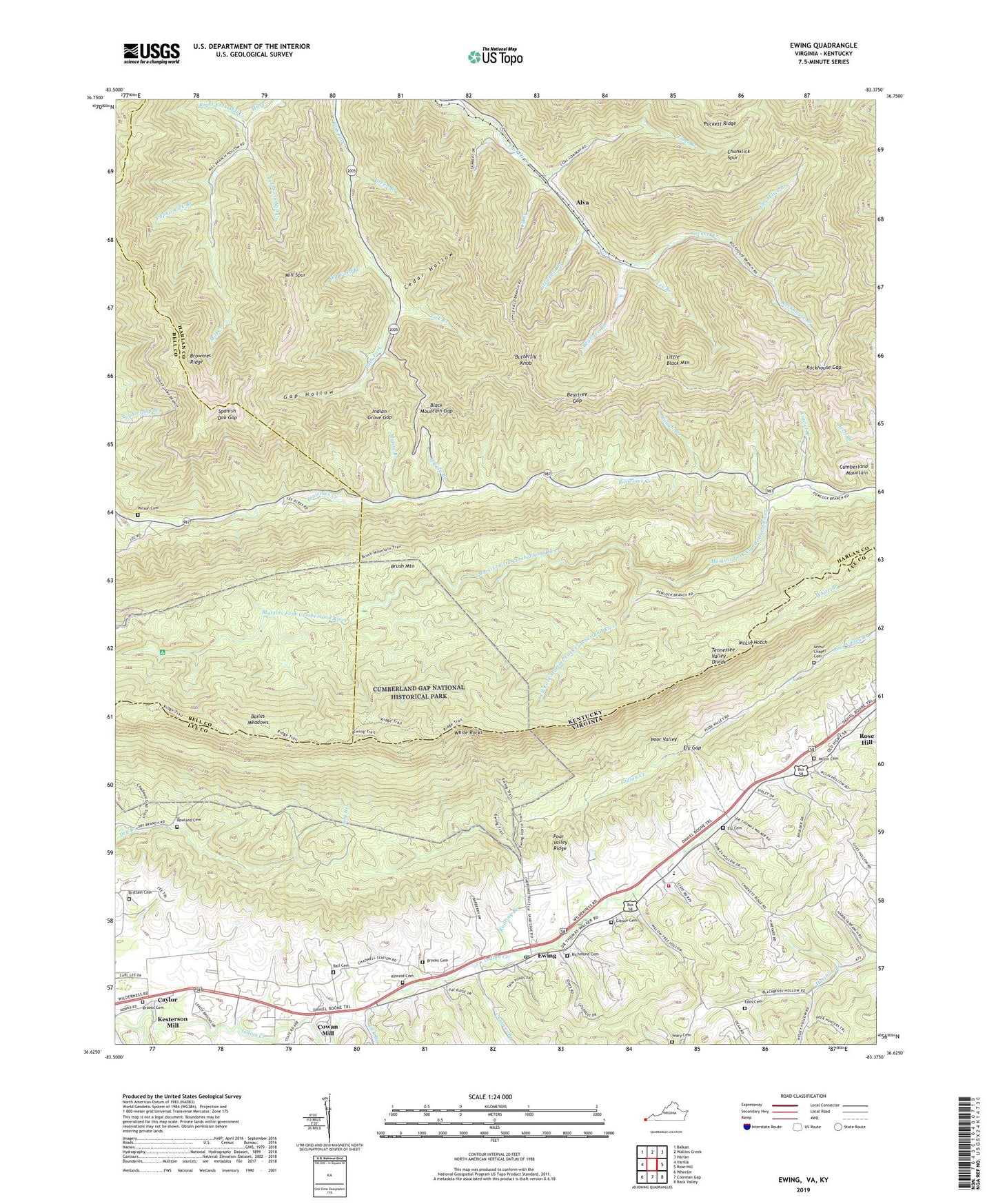
2019 topographic map quadrangle Ewing in the states of Kentucky, Virginia. Scale: 1:24000. Based on the newly updated USGS 7.5' US Topo map series, this map is in the following counties: Lee, Harlan, Bell. The map contains contour data, water features, and other items you are used to seeing on USGS maps, but also has updated roads and other features. This is the next generation of topographic maps. Printed on high-quality waterproof paper with UV fade-resistant inks.
Quads adjacent to this one:
West: Varilla
Northwest: Balkan
North: Wallins Creek
Northeast: Harlan
East: Rose Hill
Southeast: Back Valley
South: Coleman Gap
Southwest: Wheeler
Contains the following named places: Alva, Alva Division, Alva Post Office, Alva Railroad Station, Arthur Chapel, Arthur Chapel Cemetery, Avondale Post Office, Avondale School, Bailes Meadows, Ball Cemetery, Beartree Branch, Beartree Gap, Black Mountain Gap, Black Star Coal Camp, Black Star Elementary School, Brittain Cemetery, Brooks Cemetery, Brownies Creek School, Brownies Ridge, Butterfly Knob, Caylor, Cedar Hollow, Chances Branch, Chattels Station Church, Chuncklick Look Out Tower, Chunklick Branch, Chunklick Spur, Cowan Mill, Cy Branch, District 1, Edds Cemetery, Ely Cemetery, Ely Gap, Evergreen School, Ewing, Ewing Census Designated Place, Ewing Elementary School, Ewing Post Office, Fulkerson Post Office, Gap Hollow, Gibson Cemetery, Green Branch, Indian Grave Gap, Ingles Chapel, Kesterson Mill, Kincaid Cemetery, Laurel Branch, Lee Branch, Left Fork Martins Fork Cumberland River, Left Fork Mill Creek, Lick Branch, Littlefield Branch, Long Ridge Church, Lovely Branch, Lower Rose Hill Church, McLin Cemetery, McLin Notch, Meek Branch, Mill Spur, Moore Branch, Mount Carmel Church, Old Field Branch, Poplar Lick Branch, Richmond Cemetery, Right Fork Mill Creek, Roaring Branch, Rockhouse Branch, Rockhouse Gap, Rose Hill Census Designated Place, Rose Hill District, Rough Branch, Rowland Cemetery, Saylor Post Office, Spanish Oak Gap, Thomas Walker Fire Department Station 1, Thomas Walker High School, Toms Branch, Upper Martins Fork School, White Rocks, Wilson Cemetery, Yeary Cemetery, ZIP Code: 40863