MyTopo
Wheeler Virginia US Topo Map
Couldn't load pickup availability
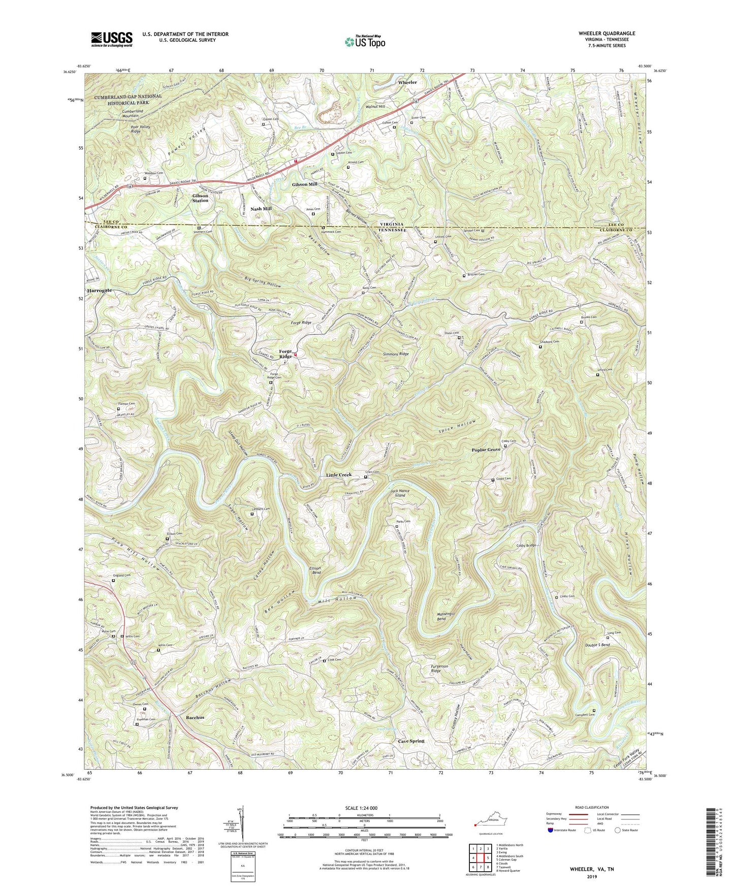
2022 topographic map quadrangle Wheeler in the states of Tennessee, Virginia. Scale: 1:24000. Based on the newly updated USGS 7.5' US Topo map series, this map is in the following counties: Lee, Claiborne. The map contains contour data, water features, and other items you are used to seeing on USGS maps, but also has updated roads and other features. This is the next generation of topographic maps. Printed on high-quality waterproof paper with UV fade-resistant inks.
Quads adjacent to this one:
West: Middlesboro South
Northwest: Middlesboro North
North: Varilla
Northeast: Ewing
East: Coleman Gap
Southeast: Howard Quarter
South: Tazewell
Southwest: Clouds
This map covers the same area as the classic USGS quad with code o36083e5.
Contains the following named places: Allen Mill, Arnold Cemetery, Bacchus, Bacchus Hollow, Bacchus School, Barnes Hollow, Bee Branch, Bee Hollow, Bethel Baptist Church, Big Spring Hollow, Blair Creek Church, Brittian Cemetery, Brooks Cemetery, Bussell Ford, Campbell Cemetery, Campbell Ford, Caney Hollow, Canoe Branch, Cave Spring, Cave Spring Creek, Cave Springs Baptist Church, Cedar Fork Creek, Chadwell Cemetery, Colson Cemetery, Commissioner District 5, Commissioner District 6, Cook Cemetery, Cosby Bridge, Cosby Cemetery, Cosby Ford, Crain Cemetery, Crocket Furnace, Cumberland Gap Division, Dixon Cemetery, Double S Bend, Ellison Bend, Ellison Cemetery, Ellison Mill, England Cemetery, Ensor Cemetery, Fergerson School, Flemon Cemetery, Forge Ridge, Forge Ridge Baptist Church, Forge Ridge Cemetery, Forge Ridge High School, Freeman Cemetery, Fulton School, Furgerson Chapel, Furgerson Ridge, Gibson Cemetery, Gibson Mill, Gibson Pond, Gibson Station, Grassy Hollow, Greers Chapel, Greers School, Hammock Cemetery, Highland View School, Hines Hollow, Horse Hollow, Indian Creek, Indian Creek Church, Island Creek, Jack Nance Island, Jones Cemetery, Keck Hollow, Kelly Cemetery, Lambert Cemetery, Liford Cemetery, Little Creek, Little Creek Baptist Church, Little Creek School, Littrell Cemetery, Long Cemetery, Machine Branch, Massengill Bend, Mill Hollow, Mount Gilead Church, Mount Pleasant Church, Nash Mill, North Claiborne Volunteer Fire Department Station 1, Ownes Cemetery, Parks Cemetery, Pendleton Branch, Pine Hill School, Pines Creek, Poplar Grove, Poplar Grove Missionary Baptist Church, Poplar Grove School, Ridgedale School, Riverside, Riverside Church, Riverside School, Rob Camp, Russell Creek, Simmons Ridge, Southern Cemetery, Spice Hollow, Sproles Cemetery, Station Creek, Steep Gut Hollow, Sugar Hollow, Thomas Walker Volunteer Fire Department Station 2, Walnut Hill, Walnut Hill Church, Walnut Hill School, West Fork Little Creek, Wheeler, Wheeler Hollow, Willis Cemetery, Woodson Cemetery, Wylie Cemetery, Wylie School, Yellow Shoals Ford, ZIP Code: 37752