
MyTopo
Goshen Virginia US Topo Map
Couldn't load pickup availability
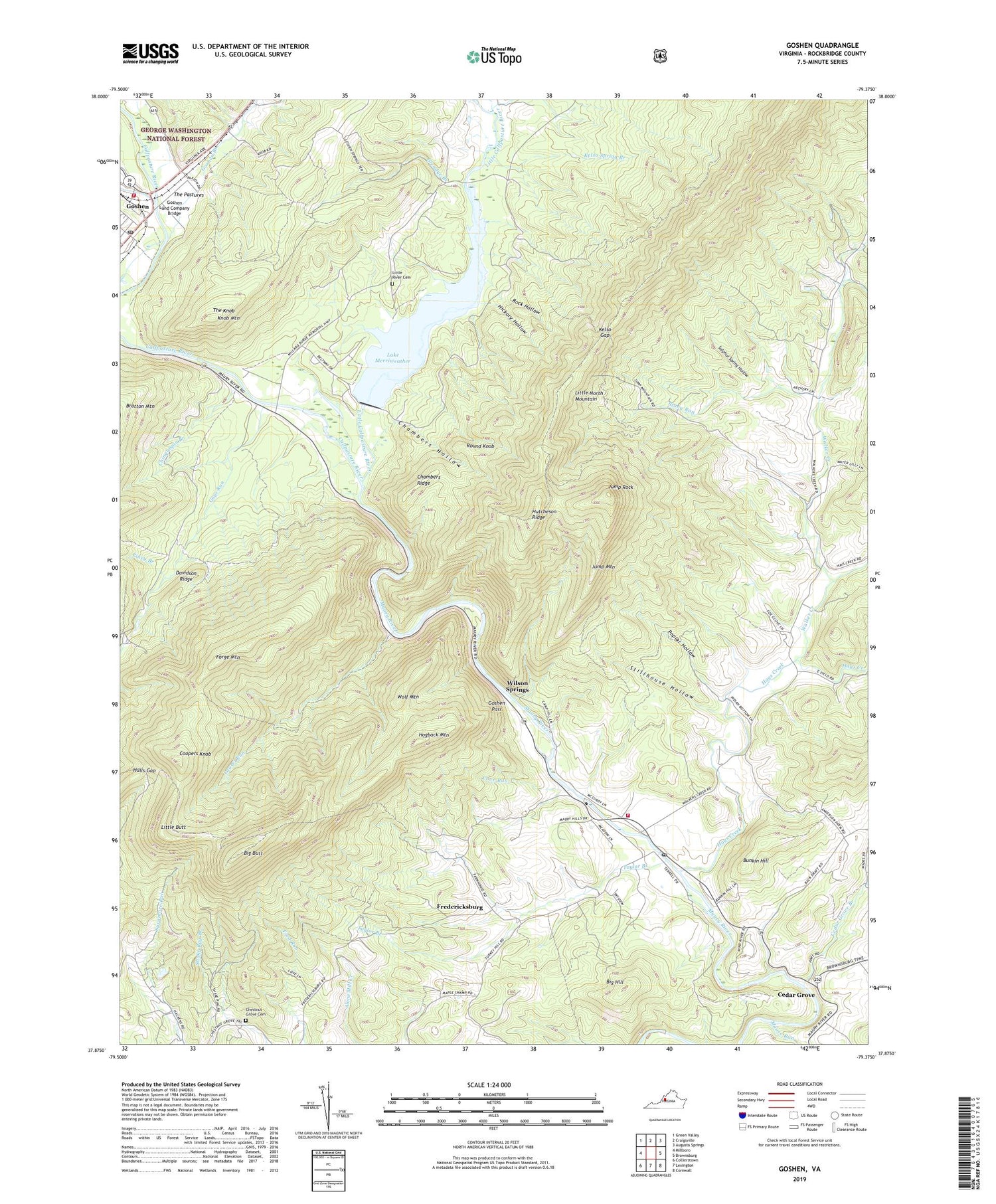
2019 topographic map quadrangle Goshen in the state of Virginia. Scale: 1:24000. Based on the newly updated USGS 7.5' US Topo map series, this map is in the following counties: Rockbridge. The map contains contour data, water features, and other items you are used to seeing on USGS maps, but also has updated roads and other features. This is the next generation of topographic maps. Printed on high-quality waterproof paper with UV fade-resistant inks.
Quads adjacent to this one:
West: Millboro
Northwest: Green Valley
North: Craigsville
Northeast: Augusta Springs
East: Brownsburg
Southeast: Cornwall
South: Lexington
Southwest: Collierstown
Contains the following named places: Anderson Trail, Bethesda Presbyterian Church, Big Butt, Big Hill, Bunkin Hill, Burke Trail, Calfpasture River, Camp Baird, Camp Bowman, Camp Marriott, Camp Okahahwis, Camp Olmsted, Camp PMI, Camp Ross, Camp Virginia, Cedar Grove, Cedar Grove Branch, Chambers Hollow, Chambers Ridge, Chestnut Grove Cemetery, Chestnut Grove Church, Chinquapin Branch, Coopers Knob, Cove Run, Crawford School, Davidson Ridge, Devils Kitchen, Dutch Hollow Branch, Ford School, Forge Mountain, Fredericksburg, Glendye Branch, Goshen, Goshen Branch, Goshen Dam, Goshen First Aid Crew Rescue 13, Goshen Land Company Bridge, Goshen Pass, Goshen Pass Trail, Goshen Post Office, Goshen Volunteer Fire Department, Gospel Hill School, Guys Run, Hays Creek, Hickory Hollow, Hogback Mountain, Hulls Gap, Hunters Trail, Hutcheson Ridge, Jump Mountain, Jump Rock, Jump Rock Trail, Kelso Gap, Kelso Spring Branch, Knob Mountain, Krider Trail, Lake Merriweather, Laurel Run, Little Butt, Little Calfpasture River, Little Peak Trail, Little River Cemetery, Little River Church, Maury Monument, Mill Creek, Missing Link Trail, Mountain View Farm Greenhouses, Mouse Run, Old Bridge Trail, Piney Branch, Poplar Hollow, Riverside School, Rock Hollow, Rockbridge Baths, Rockbridge Baths Post Office, Rockbridge Baths Volunteer Fire Department Company 6, Round Knob, Round Knob Trail, Seay Trail, Shore Trail, Stillhouse Hollow, Stony Run, Sulphur Spring Hollow, Taylor Branch, The Knob, The Pastures, Tuscarora Trail, Viewing Rock Trail, Walker Creek, Walkers Creek District, Wilson Springs, Wolf Mountain, ZIP Codes: 24439, 24473


