MyTopo
Mathews Virginia US Topo Map
Couldn't load pickup availability
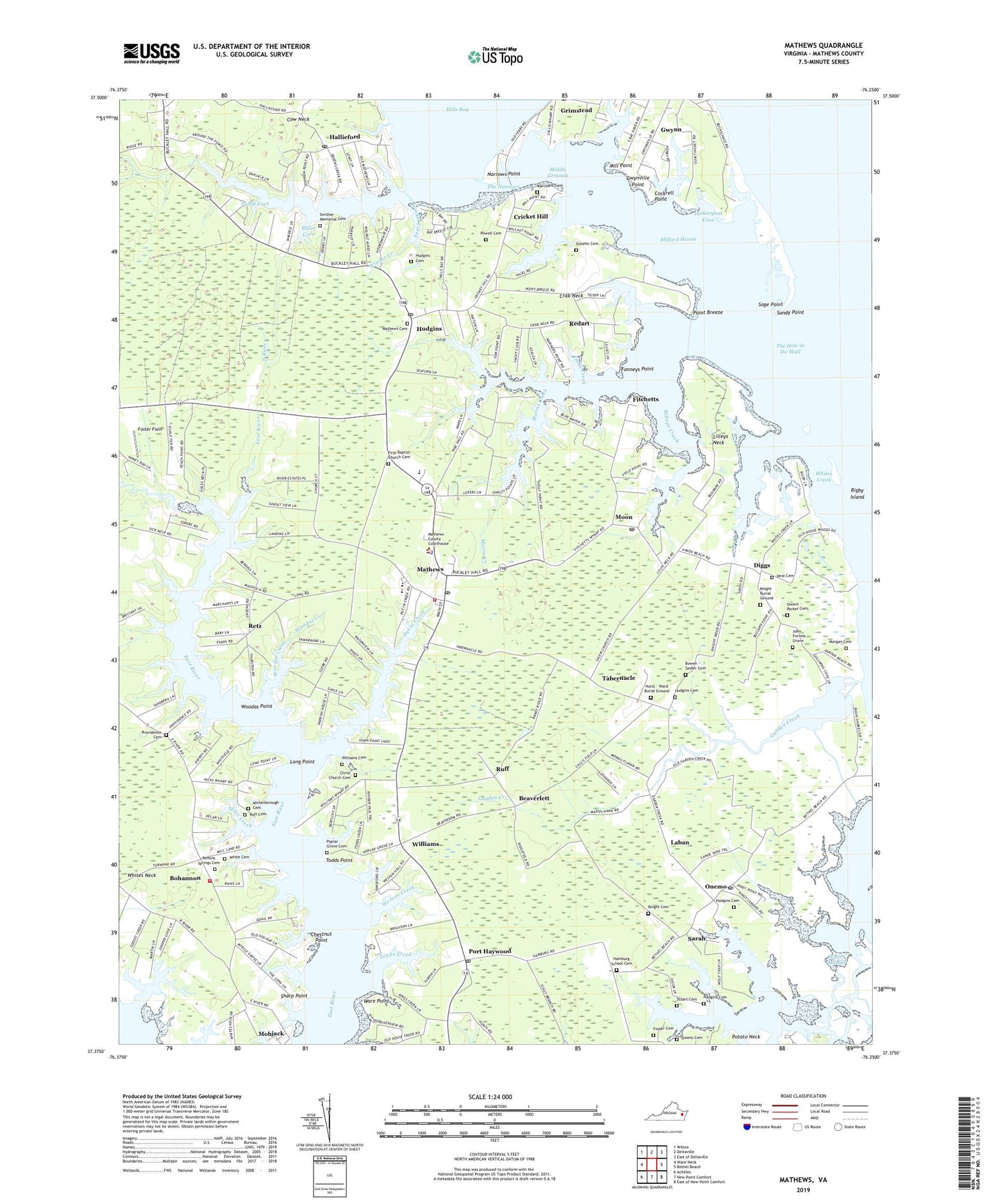
2022 topographic map quadrangle Mathews in the state of Virginia. Scale: 1:24000. Based on the newly updated USGS 7.5' US Topo map series, this map is in the following counties: Mathews. The map contains contour data, water features, and other items you are used to seeing on USGS maps, but also has updated roads and other features. This is the next generation of topographic maps. Printed on high-quality waterproof paper with UV fade-resistant inks.
Quads adjacent to this one:
West: Ware Neck
Northwest: Wilton
North: Deltaville
Northeast: East of Deltaville
East: Bethel Beach
Southeast: East of New Point Comfort
South: New Point Comfort
Southwest: Achilles
This map covers the same area as the classic USGS quad with code o37076d3.
Contains the following named places: Back Creek, Barn Creek, Beaverdam School, Beaverlett, Bethel Church, Billups Creek, Blakes, Bohannon, Bowen - Sadler Cemetery, Callis Creek, Callis Wharf, Cattail School, Cedar Lane Landing, Chestnut Point, Christ Church, Christ Church Cemetery, Cockrell Point, Cow Neck, Crab Neck, Cricket Hill, Deal Cemetery, Diggs, Edwards Creek, Emmanuel Church, Fanneys Point, First Baptist Church, First Baptist Church Cemetery, Fitchett Wharf Landing, Fitchetts, Foster Cemetery, Foster Field, Garden Creek, Godsey Creek, Gosehn Cemetery, Grimstead Landing Boat Ramp, Gwynn Census Designated Place, Gwynn Island Landing, Gwynville Point, Hallieford, Hallieford Post Office, Hamburg School, Hamburg School Cemetery, Haven, Haven Beach, Hickorynut Cove, Hicks Wharf, Hills Bay, Hills Creek, Hudgins, Hudgins Cemetery, Hudgins Creek, Hudgins Post Office, Hurst - Ward Burial Ground, John Forrest Grave, Kenney Creek, Knight Burial Ground, Knight Cemetery, Laban, Lanes Creek, Lawrenceville School, Lee - Jackson Elementary School, Lilleys Neck, Long Point, Marchant Cemetery, Mathews, Mathews Cemetery, Mathews Census Designated Place, Mathews Church, Mathews County, Mathews County Courthouse, Mathews County Government Center, Mathews County Senior Center, Mathews County Sheriff's Office, Mathews County Youth Center, Mathews High School, Mathews Memorial Library, Mathews Post Office, Mathews Raceway, Mathews Volunteer Fire Department Station 1, Mathews Volunteer Fire Department Station 2, Mathews Volunteer Rescue Squad, Methodist Tabernacle, Mickelborough Cemetery, Middle Grounds, Miles Creek, Miles Store, Milford Haven, Milford Landing, Milford Landing Boat Ramp, Mill Point, Miller Cove, Mobjack, Moon, Moon Post Office, Morgan Cemetery, Morris Creek, Narrows Marina, Narrows Point, Oak Grove Church, Onemo, Onemo Post Office, Owens - Parker Cemetery, Owens Cemetery, Peniel Church, Perkins Springs Cemetery, Perrin Boat Yard, Piankatank District, Pine Hall, Point Breeze, Poplar Grove Cemetery, Port Haywood, Port Haywood Post Office, Postle Cove, Powell Cemetery, Providence Cemetery, Put in Creek, Queens Creek Landing, Raines Creek, Redart, Retz, Rigby Island, Riverside Convalescent Center at Mathews, Roses Creek Landing Boat Ramp, Ruff, Ruff Cemetery, Sage Point, Salem Church, Sandy Point, Sarah, School B, Sharp Point, Smither Memorial Cemetery, Stoakes Creek, Stuart Cemetery, Tabbs Creek, Tabernacle, The Hole in the Wall, The Narrows, Thomas Creek, Thomas Hunter Middle School, Todds Point, Town Point Landing, Town Point Landing Boat Ramp, Ware Point, Wayland Church, Weston Creek, Westville Church, Westville District, Westville School, Wharf Creek, Wharf Lane School, White Cemetery, Whites Creek, Whites Creek Landing Boat Ramp, Whites Neck, Williams, Williams Cemetery, Williams Wharf, Williams Wharf Landing, Winder Creek, Winter Harbor, Winter Harbor Haven, Winter Harbor Haven Boat Ramp, Winter Harbor Haven Marina, Winter Harbor Landing, Winter Harbor Landing Boat Ramp, Woodas Creek, Woodas Point, Zion Church, ZIP Codes: 23021, 23025, 23045, 23064, 23066, 23076, 23109, 23119, 23130