MyTopo
Achilles Virginia US Topo Map
Couldn't load pickup availability
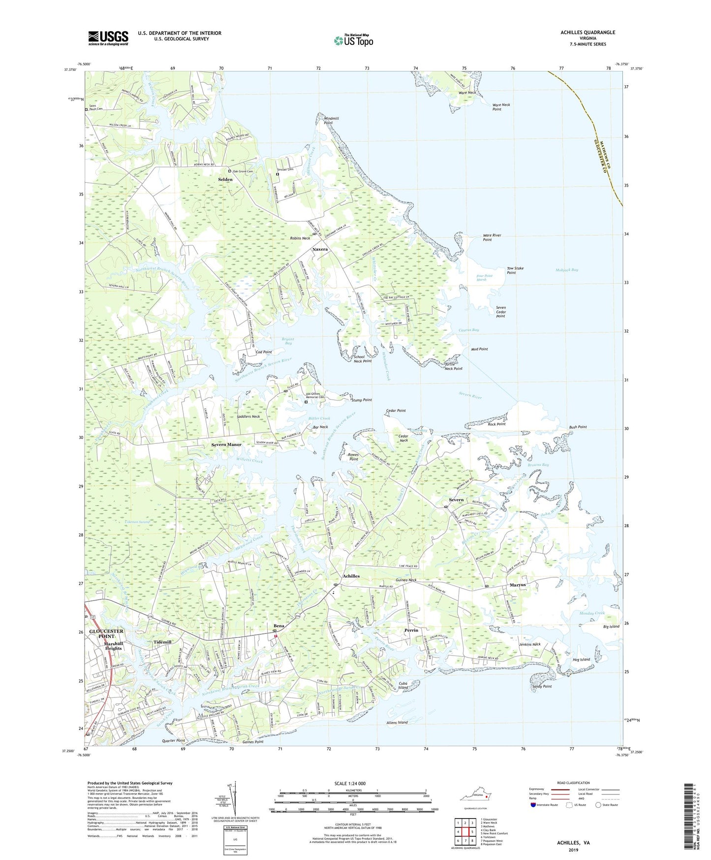
2022 topographic map quadrangle Achilles in the state of Virginia. Scale: 1:24000. Based on the newly updated USGS 7.5' US Topo map series, this map is in the following counties: Gloucester, Mathews, York. The map contains contour data, water features, and other items you are used to seeing on USGS maps, but also has updated roads and other features. This is the next generation of topographic maps. Printed on high-quality waterproof paper with UV fade-resistant inks.
Quads adjacent to this one:
West: Clay Bank
Northwest: Gloucester
North: Ware Neck
Northeast: Mathews
East: New Point Comfort
Southeast: Poquoson East
South: Poquoson West
Southwest: Yorktown
This map covers the same area as the classic USGS quad with code o37076c4.
Contains the following named places: Abingdon Volunteer Fire and Rescue Station 2, Achilles, Achilles Elementary School, Achilles Post Office, Allens Island, Bar Neck, Belvins Boat Ramp, Bena, Bena Post Office, Bethany Church, Bethlehem Church, Big Island, Bill Browns Creek, Blevins Creek, Brays Landing, Brays Point Boat Ramp, Brayshore Park, Broad Marsh, Browns Bay, Bryant Bay, Bush Point, Butler Creek, Caucus Bay, Cedar Neck, Cedar Point, Cherry Point Landing, Cherry Point Landing Boat Ramp, Church of the Living Word, Cod Point, Coleman Swamp, Cooks Landing Boat Ramp, Crab, Crown Pointe Marina, Cuba Island, Fellowship Church, First Morning Star Church, Five Gables Plantation, Four Point Marsh, Free School Creek, Freeport Marina, Friends Church, Glass, Glass Bay, Glass Point Boat Ramp, Glass Post Office, Gloucester Banks, Gloucester Point, Gloucester Point Baptist Church, Gloucester Point Census Designated Place, Gloucester Point Marina, Gloucester Point Post Office, Gloucester Point Shopping Center, Goat Point Creek, Groves Memorial Church, Guinea Landing Boat Ramp, Guinea Neck, Hayes Plaza Shopping Center, Hayes Post Office, Heywood Creek, Hoffman's Farm Airport, Hog Island, Holiday Marina, Holly Bush Creek, Holly Cove Marina, Jenkins Neck, Jenkins Neck Boat Ramp, Jenkins Neck Landing, John West Creek, Johns Point Boat Ramp, Johns Point Landing, Jordan Marine Services, King Boat Ramp, King Creek, Kings Landing, Lady, Lady Creek, Lands End, Little Monday Creek, Long Creek, Marshall Heights, Maryus, Maryus Post Office, Mill Creek, Monday Creek, Monday Creek Boat Ramp, Mud Point, Naxera, Naxera Post Office, New Testament Tabernacle, Nicholsons Marina, North River, Northeast Branch Sarah Creek, Northwest Branch Sarah Creek, Northwest Branch Severn River, Oak Grove Cemetery, Old Groves Memorial Cemetery, Oldhouse Creek, Oyster Cove, Page Creek, Paynes Landing, Paynes Landing Boat Ramp, Perrin, Perrin River, Point Lookout, Quiet Cove, Roanes Wharf, Robins Neck, Rock Point, Rosemont, Rowes Creek, Rowes Haven, Rowes Point, Saddlers Neck, Sadlers Neck School, Saint Pauls Cemetery, Saint Pauls Church, Sandy Point, Sarah Creek, Sarahs Creek Marina, School Neck Point, Sedger Creek Boat Ramp, Sedger Creek Landing, Selden, Seven Cedar Point, Severn, Severn Church, Severn Manor, Severn Post Office, Severn River, Severn River Landing Boat Ramp, Severn River Marina, Severn Wharf, Shiloh Church, Sinclair Cemetery, Sinclair Creek, Southwest Branch Severn River, Sterling Creek, Stump Point, Thomas Creek, Thorntons Creek, Tidemill, Tidemill Branch Library, Tidemill Shopping Center, Tow Stake Point, Turtle Neck Point, Union Church, Vaughans Creek, Victory Hill, Ware Neck Point, Ware River, Ware River Point, Waterview Mobile Home Park, Whitehall Plantation, Whittaker Creek, Willetts Creek, Wilson Creek, Windmill Point, York District, York River Crossing Shopping Center, York River Farms, York River Yacht Haven, ZIP Code: 23072