MyTopo
Old Rag Mountain Virginia US Topo Map
Couldn't load pickup availability
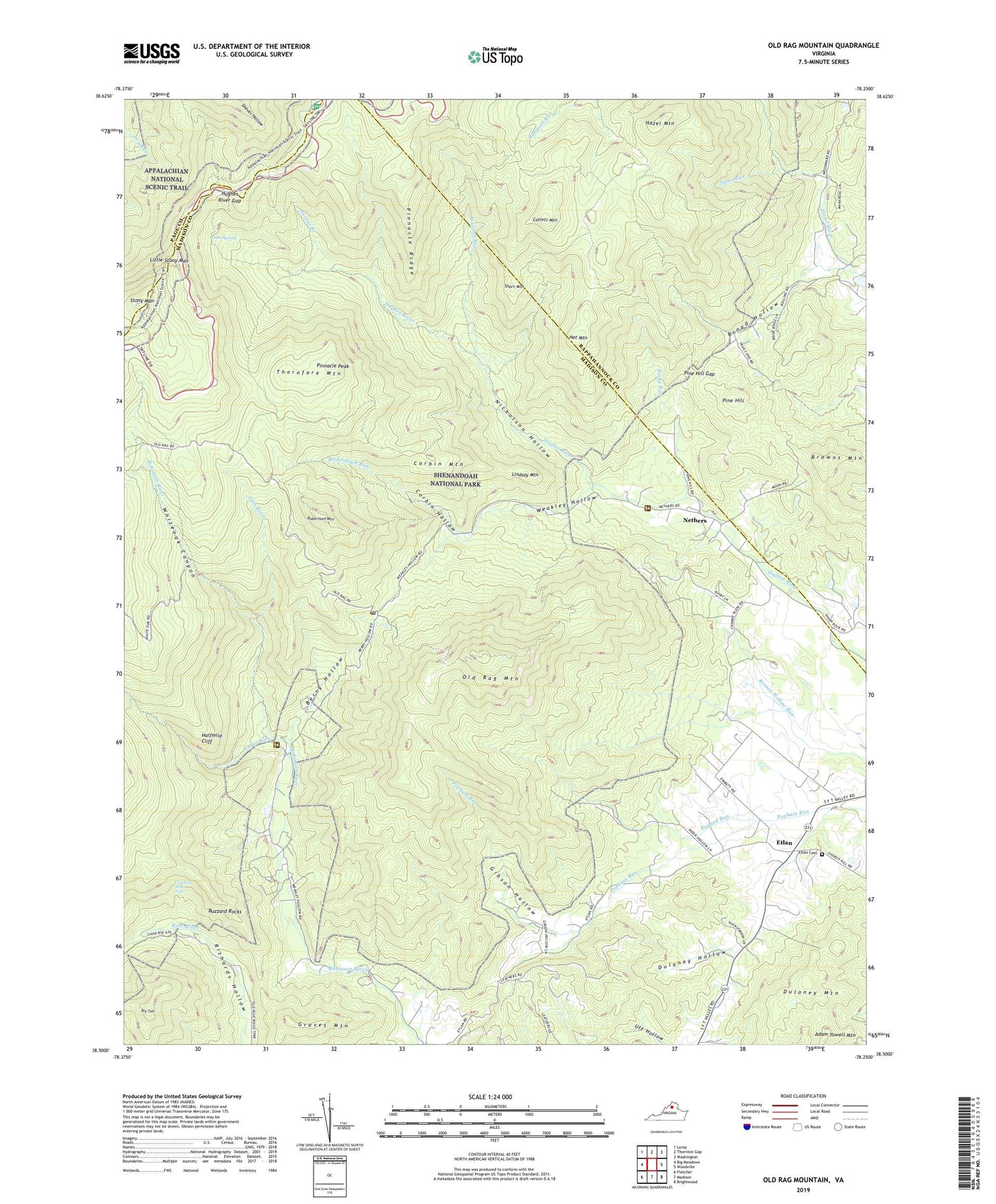
2019 topographic map quadrangle Old Rag Mountain in the state of Virginia. Scale: 1:24000. Based on the newly updated USGS 7.5' US Topo map series, this map is in the following counties: Madison, Rappahannock, Page. The map contains contour data, water features, and other items you are used to seeing on USGS maps, but also has updated roads and other features. This is the next generation of topographic maps. Printed on high-quality waterproof paper with UV fade-resistant inks.
Quads adjacent to this one:
West: Big Meadows
Northwest: Luray
North: Thornton Gap
Northeast: Washington
East: Woodville
Southeast: Brightwood
South: Madison
Southwest: Fletcher
Contains the following named places: Aaron Nicholson House, Aarons Branch, Adam Yowell Mountain, Berry Hollow, Bethlehem United Methodist Church, Big Tom, Broad Hollow, Broad Hollow Trail, Brokenback Run, Browns Mountain, Buzzard Rocks, Byrds Nest Number 1, Camp Ridge Trail, Catlett Mountain, Catlett Mountain Trail, Cedar Run, Cedar Run Trail, Climbing Rose Falls, Corbin Cabin, Corbin Cabin Trail, Corbin Hollow, Corbin Mountain, Corbin Mountain Trail, Dale Spring, Dulaney Hollow, Dulaney Mountain, Etlan, Etlan Cemetery, Etlan Church, Etlan United Methodist Church, Ferham School, Gibson Hollow, Graves Mountain, Halfmile Cliff, Hannah Run, Hannah Run Trail, Hazel Mountain, Hazel School, Hemlock Springs Overlook, Hot Mountain, Hot Short Mountain Trail, Hughes River Church, Hughes River Gap, Indian Run Trail, Lindsay Mountain, Little Stony Man, Nethers, Nethers Mill Lighthouse Tabernacle, Nicholson Hollow, Nicholson Hollow Trail, Old Rag Mountain, Old Rag Shelter, Oldrag, Oldrag Post Office, Piedmont Church, Pine Hill, Pine Hill Gap, Pine Hill Gap Trail, Pinnacle Overlook, Pinnacle Peak, Pinnacle Ridge, Pinnacle Ridge Trail, Pinnacles Picnic Grounds, Pleasant Grove Church, Ragged Run, Ridge Trail, Robertson Mountain, Robertson Mountain Trail, Rocky Run, Saddle Trail, Sams Ridge Trail, Sams Run, Sexton Shelter, Shaver Hollow Shelter, Shenandoah Research and Resource Management Center, Short Mountain, Stony Man, Stony Man Overlook, The Island, Thorofare Mountain, Thorofare Mountain Overlook, Thorofare Mountain School, Tims River, Weakley Hollow, White Oak Ranger Station, Whiteoak Canyon, ZIP Code: 22719