MyTopo
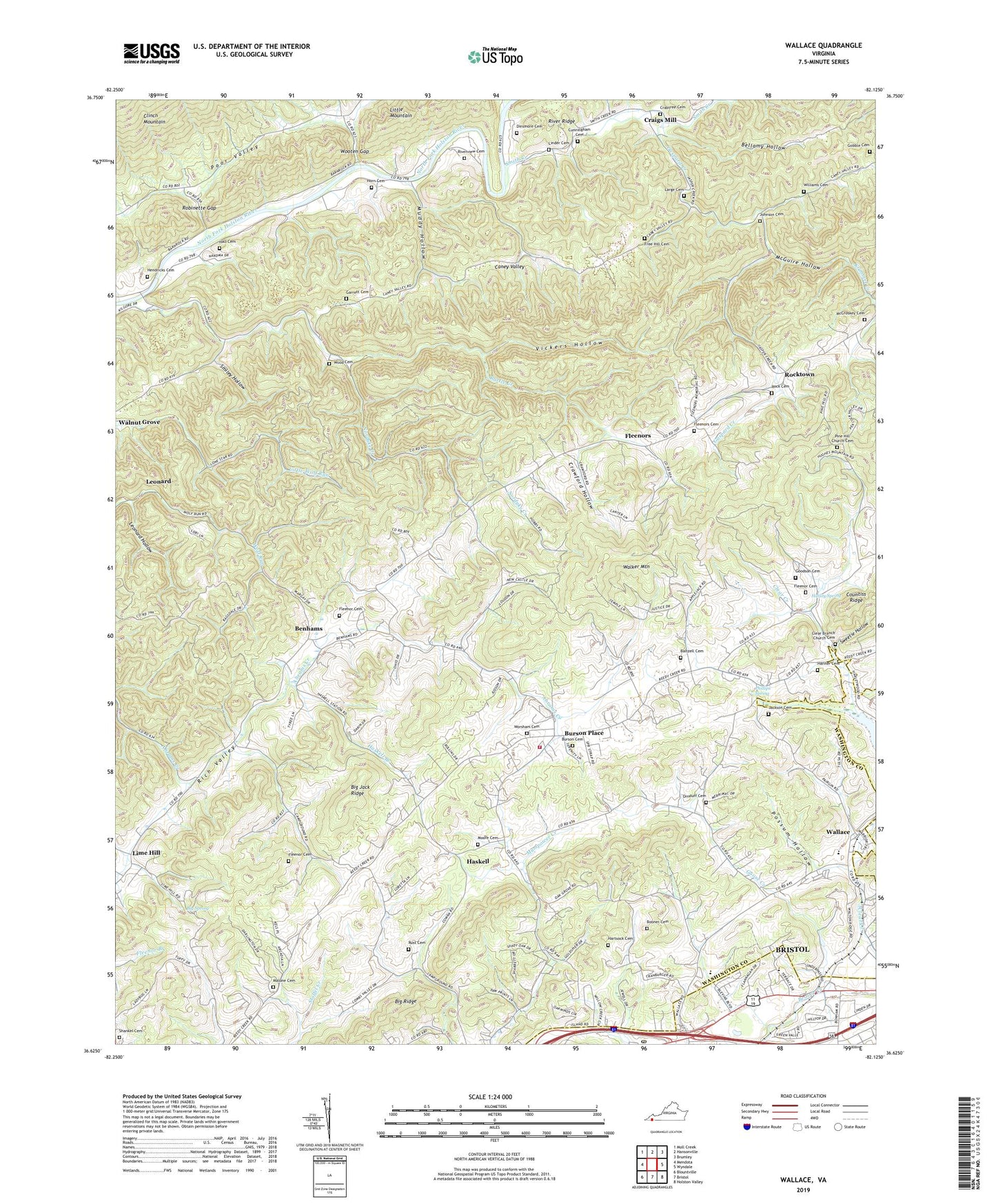
Wallace Virginia US Topo Map
Couldn't load pickup availability
2022 topographic map quadrangle Wallace in the state of Virginia. Scale: 1:24000. Based on the newly updated USGS 7.5' US Topo map series, this map is in the following counties: Washington, Bristol (city). The map contains contour data, water features, and other items you are used to seeing on USGS maps, but also has updated roads and other features. This is the next generation of topographic maps. Printed on high-quality waterproof paper with UV fade-resistant inks.
Quads adjacent to this one:
West: Mendota
Northwest: Moll Creek
North: Hansonville
Northeast: Brumley
East: Wyndale
Southeast: Holston Valley
South: Bristol
Southwest: Blountville
This map covers the same area as the classic USGS quad with code o36082f2.
Contains the following named places: Baltzell Cemetery, Bellamy Hollow, Benhams, Bethany Church, Big Jack Ridge, Big Ridge, Big Spring, Booner Cemetery, Bristol Reservoir, Bufallo Pond School, Buffalo Ford, Buffalo School, Burson Cemetery, Burson Place, Calvary Bible Church, Campground Church, Caney Valley, Cedar Grove Church, Centenary Church, Chinquapin School, Clear Branch Church, Clear Branch Church Cemetery, Crabtree Cemetery, Craigs Mill, Craigs Mill School, Crawford Hollow, Crystal Pool, Cunningham Cemetery, Dinsmore Cemetery, Dominion Post Office, Fleenor Cemetery, Fleenor Spring, Fleenors, Fleenors Cemetery, Free Hill Cemetery, Free Hill Church, Garrett Cemetery, Gaspard Creek, Gobble Cemetery, Goodson - Kinderhook Fire and Rescue Station 1, Goodson Cemetery, Goose Creek, Gum Hill Church, Gum Hill School, Gunpowder Siding, Hall Cemetery, Hanner Cemetery, Harley Spring, Hartsock Cemetery, Haskell, Haskell Branch, Hendricks Cemetery, Horn Cemetery, Jackson Cemetery, Johnson Cemetery, Krimmel Creek, Large Cemetery, Leonard, Leonard Hollow, Lime Hill, Lime Hill Church, Linder Cemetery, Lippincott Church, Lone Star, Malone Cemetery, McCroskey Cemetery, McGuire Hollow, Memorial Church, Moore Cemetery, Morrison School, Mount Lebanon Church, Muddy Hollow, Nordyke, Nordyke Creek, Nordyke School, Oak Grove, Ornduff Cemetery, Phillips Spring, Pine Hill Church, Pine Hill Church Cemetery, Pine Hill School, Pleasant Dale School, Possum Hollow, Rattle Creek, Ravens Nest, Revival Center Church, Riverview Cemetery, Riverview Church, Riverview School, Robinette Gap, Rock Cemetery, Rocktown, Rush Corner, Rust Cemetery, Shankel Cemetery, Shiloh Church, Smiley Hollow, Smith Creek, Sugar Grove Church, Sugar Grove School, Sullins Academy, Sweetie Hollow, Tyler District, Vickers Hollow, Wallace, Wallace Middle School, Walnut Grove, Walnut Grove Church, Walnut Grove School, Williams Cemetery, Wolfrun, Wood Cemetery, Woodsdale, Wooten Gap, Worsham Cemetery, WZAP-AM (Bristol), ZIP Code: 24202