MyTopo
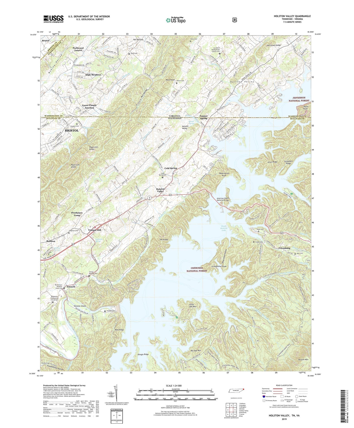
Holston Valley Tennessee US Topo Map
Couldn't load pickup availability
Also explore the Holston Valley Forest Service Topo of this same quad for updated USFS data
2022 topographic map quadrangle Holston Valley in the states of Tennessee, Virginia. Scale: 1:24000. Based on the newly updated USGS 7.5' US Topo map series, this map is in the following counties: Sullivan, Washington, Bristol (city), Carter. The map contains contour data, water features, and other items you are used to seeing on USGS maps, but also has updated roads and other features. This is the next generation of topographic maps. Printed on high-quality waterproof paper with UV fade-resistant inks.
Quads adjacent to this one:
West: Bristol
Northwest: Wallace
North: Wyndale
Northeast: Abingdon
East: Shady Valley
Southeast: Doe
South: Carter
Southwest: Keenburg
Contains the following named places: 421 Area Emergency Services Volunteer Fire Department, American Legion Memorial Bridge, Beidleman Church, Beidleman Presbyterian Church Cemetery, Bent Branch, Bent Branch Spillway, Bethel Church, Bethel Presbyterian Church, Big Creek, Big Creek Lookout Tower, Big Jacob Creek, Big Oak Branch, Big Oak Mountain, Booker, Bottom Creek, Bristol Landing Field, Bristol Water Treatment Plant, Bristol Waterworks, Browns Cemetery, Buck Branch, Camp Cherokee, Cave Spring Branch, Central Church, Chapman Cemetery, Cherokee Purchase Unit, Cherokee Wildlife Management Area, Cleveland Presbyterian Church Cemetery, Cleveland School, Cold Spring, Cold Spring Cemetery, Cold Springs Presbyterian Church, Cold Springs School, Commissioner District 1, Cowan-Delaney Cemetery, Deep Hole Hollow, Edmonds Spring, Emmett, Emmett Elementary School, Fishdam, Fishdam Creek, Flatwood Trail, Fleenora Park, Friendship, Friendship Boat Dock, Friendship Chapel Baptist Church, Friendship Church, Friendship School, Goose Pimple Junction, Grandfather Knob, Hall Bottom School, High Meadows, High Point Church, High Point Elementary School, High Point School, Holston Valley, Holston Valley Church, Holston Valley Division, Holston Valley Middle School, Holston View School, Horseshoe Bend, Jacob Creek, Jacob School, Jacobs Creek Recreation Area, Jones Ridge, Josiah Creek, Ketron Cemetery, King Mill, Lakeview Dock, Laurel Yacht Club Boat Dock, Left Prong Big Creek, Little Creek, Little Jacob Creek, Little Oak Branch, Little Oak Mountain, Little Oak Recreation Area, Lucy Creek, Lynn Lick, Mock Knob, Monk Blevens Ford, Mud Hollow, New Bethel School, North Prong Fishdam Creek, Observation Knob, Observation Park, Offield Branch, Osceola Island, Paddys Branch, Painter Creek Boat Dock, Painter Spring, Painter Spring Branch, Paperville Knobs, Parkwood Estates, Pemberton-Hawkins-Grant Cemetery, Pigman Hollow, Presbytery Camp, Riddle Creek, Rosedale Church, Ross Ridge, Rudy Branch Church, Rudy Church, Rudy Hollow, Rust Cemetery, Saddle Dam, Sauls Cemetery, Scenic Park Church, Sequoya Camp, Shady Ford, Sharps Creek, Shingle Ridge, Sinking Spring Church, Sinking Spring School, Sinking Springs, South Bridge, South Cemetery, South Holston Boat Dock, South Holston Dam, South Holston Lake, Spring Creek, Stonegate, Stophel Cemetery, Stout Branch, Straight Branch, Strawbarn Ridge, Sulphur Spring Branch, Taylor Dam, Taylor Knob, Taylor Lake, The Knobs, Thomas Creek, Trivett Cemetery, Underwood Branch, Vinegar Hill, Wesley Church, Whitlock Ford, Wood Mill, Yates Cemetery, ZIP Code: 37620