MyTopo
Mukilteo Washington US Topo Map
Couldn't load pickup availability
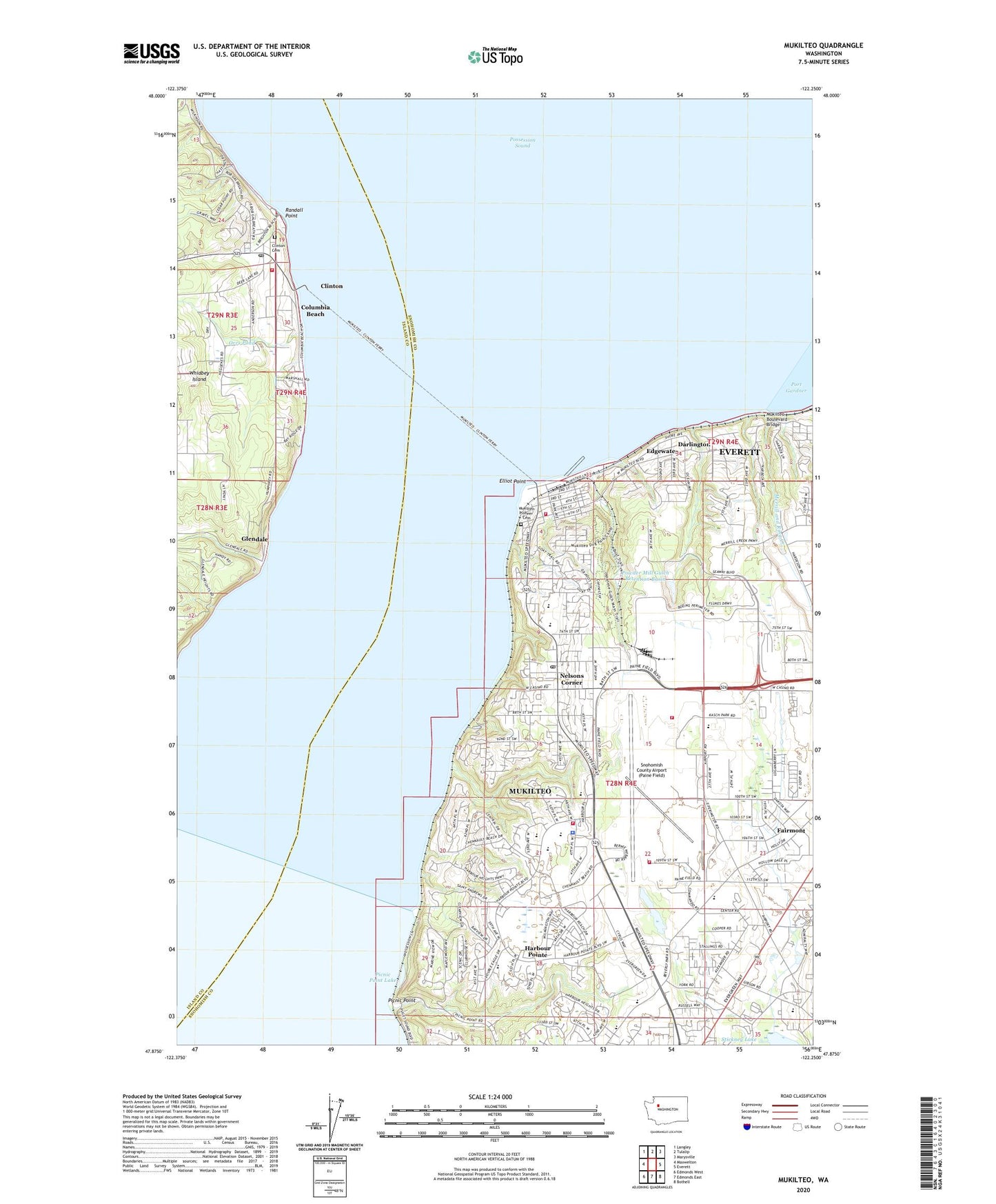
2020 topographic map quadrangle Mukilteo in the state of Washington. Scale: 1:24000. Based on the newly updated USGS 7.5' US Topo map series, this map is in the following counties: Snohomish, Island. The map contains contour data, water features, and other items you are used to seeing on USGS maps, but also has updated roads and other features. This is the next generation of topographic maps. Printed on high-quality waterproof paper with UV fade-resistant inks.
Quads adjacent to this one:
West: Maxwelton
Northwest: Langley
North: Tulalip
Northeast: Marysville
East: Everett
Southeast: Bothell
South: Edmonds East
Southwest: Edmonds West
Contains the following named places: Abundant Life Christian Fellowship Church, Airport Inn Mobile Home Park, Alderwood Sewage Treatment Plant, Alpine Mobile Home Park, Atlasta Mobile Park, Avondale Mobile Home Park, Big Gulch, Boeing Aircraft Plant, Boeing Fire Department Station 3, Boeing Flood Control Dam, Boeing-Everett Ramp Site 2 Heliport, Carriage Club Estates Mobile Home Park, Chinook Mobile Home Park, City of Mukilteo, Clinton, Clinton Cemetery, Clinton Census Designated Place, Clinton Ferry Landing, Clinton Ferry Park and Ride, Clinton Library, Clinton Park and Ride, Clinton Post Office, Columbia Beach, Columbia Elementary School, Darlington, Edgewater, Elliot Point, Endeavour Elementary School, Everett Korean Church, Everett Rehabilitation and Care Center, Fairmont, Fairmount Elementary School, Fairway Estates Senior Mobile Home Park, Flying Heritage Collection, Future of Flight Aviation Center, Gibson Substation, Glendale, Harbour Pointe, Harbour Pointe Center Shopping Center, Harbour Pointe Early Learning Center, Harbour Pointe Middle School, Harbour Pointe Montessori School, Harbour Pointe Retirement and Assisted Living Center, Hers Industrial Park, Island County Fire Protection District 3 South Whidbey Fire / EMS Clinton Station 32, Japanese Gulch, Kamiak High School, Kindercare Learning Center 1604, Kindercare Learning Center 467 Mukilteo, La Petite Academy Beverley Park, Lake Stickney, Lake Stickney Mobile Home Park, Lakeside Recreational Vehicle Park, Loganberry Mobile Home Park, Merrill and Ring Creek, Mukilteo, Mukilteo Academy, Mukilteo Boulevard Bridge, Mukilteo Elementary School, Mukilteo Ferry Landing, Mukilteo Fire Department Station 24, Mukilteo Fire Department Station 25, Mukilteo Lighthouse, Mukilteo Montessori Preschool and Kindergarten, Mukilteo Pioneer Cemetery, Mukilteo Police Department, Mukilteo Post Office, Mukilteo Public Library, Mukilteo State Park, Mukilteo Substation, Mukilteo Water District Sewage Treatment Plant, Nelsons Corner, Northshore Christian Academy, Odyssey Elementary School, Olympic View Middle School, Orrs Pond, Orrs Pond Dam, Paine Field-Lake Stickney Census Designated Place, Picnic Point, Picnic Point Lake, Possession Sound, Powder Mill Gulch, Powder Mill Gulch Retention Basin, Randall Point, Rural/Metro of Washington, Saint Peter's Lutheran Church, Shady Lawn Mobile Home Park, Sno - Isle Skills Center, Snohomish County Airport (Paine Field), Snohomish County Airport Paine Field Fire Department, Sonrise Chapel, Stickney Lake, Summit Program Elementary School, Todays Church, Universal Life Church, Walter E Hall Municipal Golf Course, ZIP Codes: 98204, 98275