MyTopo
Yakima West Washington US Topo Map
Couldn't load pickup availability
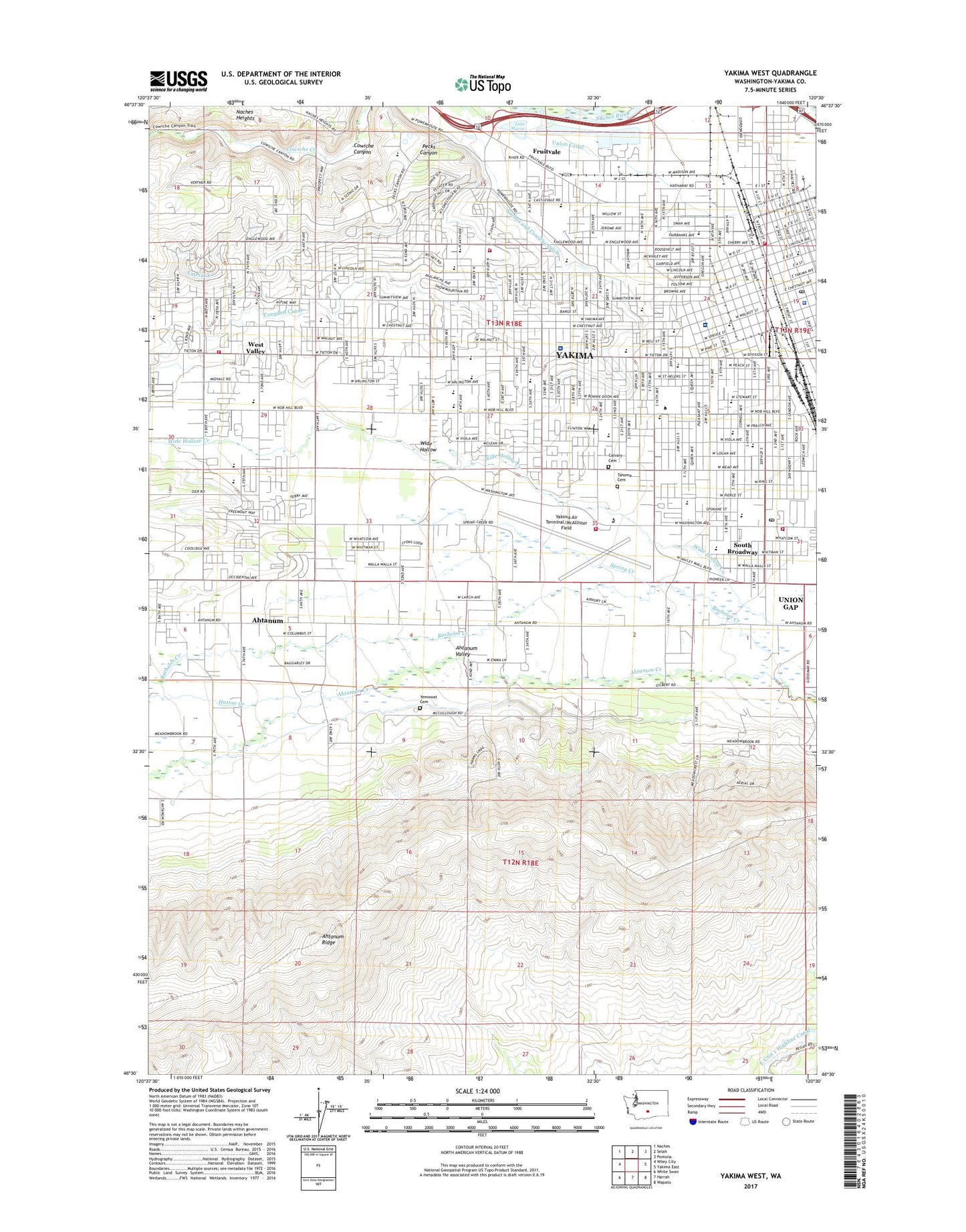
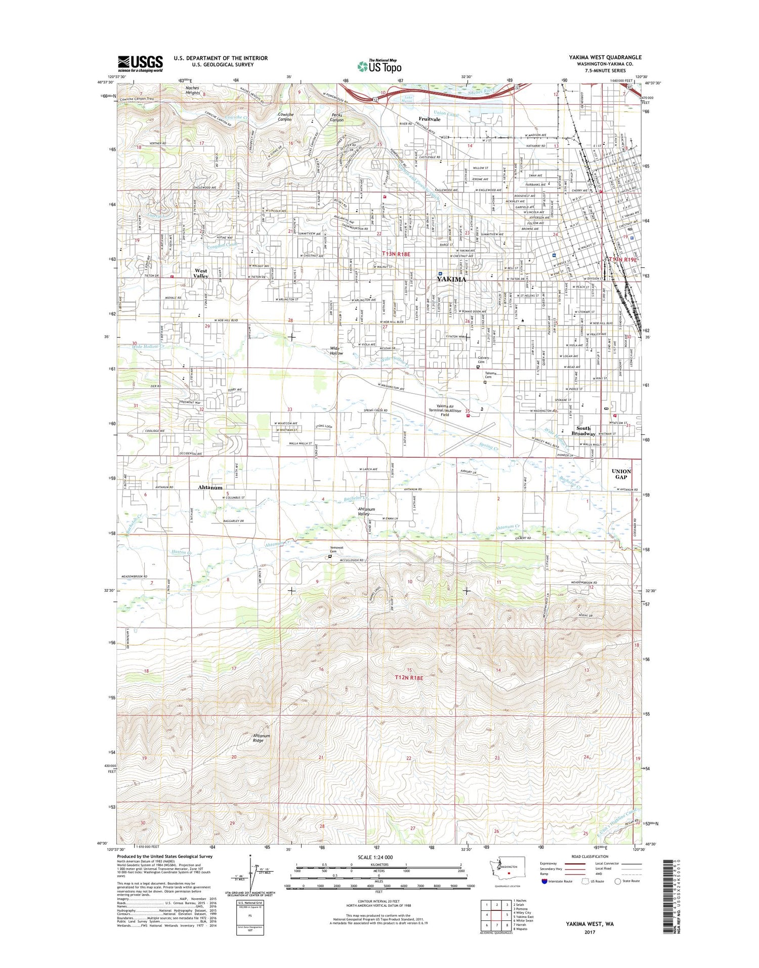
2020 topographic map quadrangle Yakima West in the state of Washington. Scale: 1:24000. Based on the newly updated USGS 7.5' US Topo map series, this map is in the following counties: Yakima. The map contains contour data, water features, and other items you are used to seeing on USGS maps, but also has updated roads and other features. This is the next generation of topographic maps. Printed on high-quality waterproof paper with UV fade-resistant inks.
Quads adjacent to this one:
West: Wiley City
Northwest: Naches
North: Selah
Northeast: Pomona
East: Yakima East
Southeast: Wapato
South: Harrah
Southwest: White Swan
Contains the following named places: Advanced Life Systems Ambulance Service, Ahtanum, Ahtanum Census Designated Place, Ahtanum Valley, Ahtanum Youth County Park, American Medical Response, Apple Valley Airport, Apple Valley Elementary School, Bachelor Creek, Bannister, Barge - Lincoln Elementary School, Barge-Lincoln Elementary School, Broadway Park, Brookside Academy, Calvary Cemetery, Castlevale School, Central High School, Central Post Office, Chalet Mall Shopping Center, City of Yakima, Congdon, Congdon Canal, Congdon Orchards, Davis High School, Don Williams Private Heliport, East Unit 1 Highline Canal, Eastman, Eisenhower High School, Elks Memorial Park, Exchange, Franklin Middle School, Franklin Park, Fruitvale, Garfield Elementary School, Gilbert Elementary School, Gilbert Park, Glenwood Shopping Center, Grace Lutheran School, Hatton Creek, Hoover Elementary School, Johnson Orchards, KAPP-TV (Yakima), KATS-FM (Yakima), KDNA-FM (Yakima), KIMA-TV (Yakima), Klein School, KNDO-TV (Yakima), KSOH-FM (Wapato), KYSC-FM (Yakima), KYVE-TV (Yakima), Lake Myron, Larson Park, Lateral L, Lewis and Clark Middle School, Lions Park, Mallett, McClure Elementary School, McKinley Elementary School, Meadow Brook, Meadowbrook Mall, Miller Park, Milroy Park, Naches and Cowiche Ditch, Nob Hill Elementary School, Nob Hill Plaza, Orchard, Pecks Canyon, Perry Technical Institute, Ridge View Elementary School, Robertson Elementary School, Roosevelt Elementary School, Saint Elizabeth Hospital Heliport, Saint Joseph Marquette Catholic School, Saint Paul Cathedral School, Schwarder, South Broadway, Southgate Shopping Center, Spring Creek, Stanton Alternative School, Stewart, Summitview Elementary School, Tahoma Cemetery, Union Canal, Union Gap Fire Department Station 86, Vanvleck Orchards, West Side Christian School, West Valley, West Valley Junior High School, Westpark Shopping Center, Whitney Elementary School, Wide Hollow, Wide Hollow Elementary School, Wilkinson Orchards, Wilson Middle School, Yakima, Yakima Air Terminal/McAllister Field, Yakima Army Air Field, Yakima County Department of Corrections, Yakima Fire Department Station 91, Yakima Fire Department Station 92, Yakima Fire Department Station 93, Yakima Fire Department Station 94, Yakima Mall, Yakima Police Department, Yakima Post Office, Yakima Regional Medical and Cardiac Center, Yakima Valley Community College, Yakima Valley Memorial Hospital, Yakima Valley Memorial Hospital Heliport, Yemowat Cemetery, ZIP Code: 98902