MyTopo
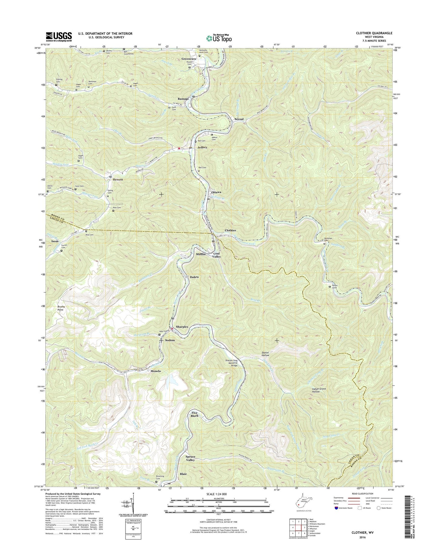
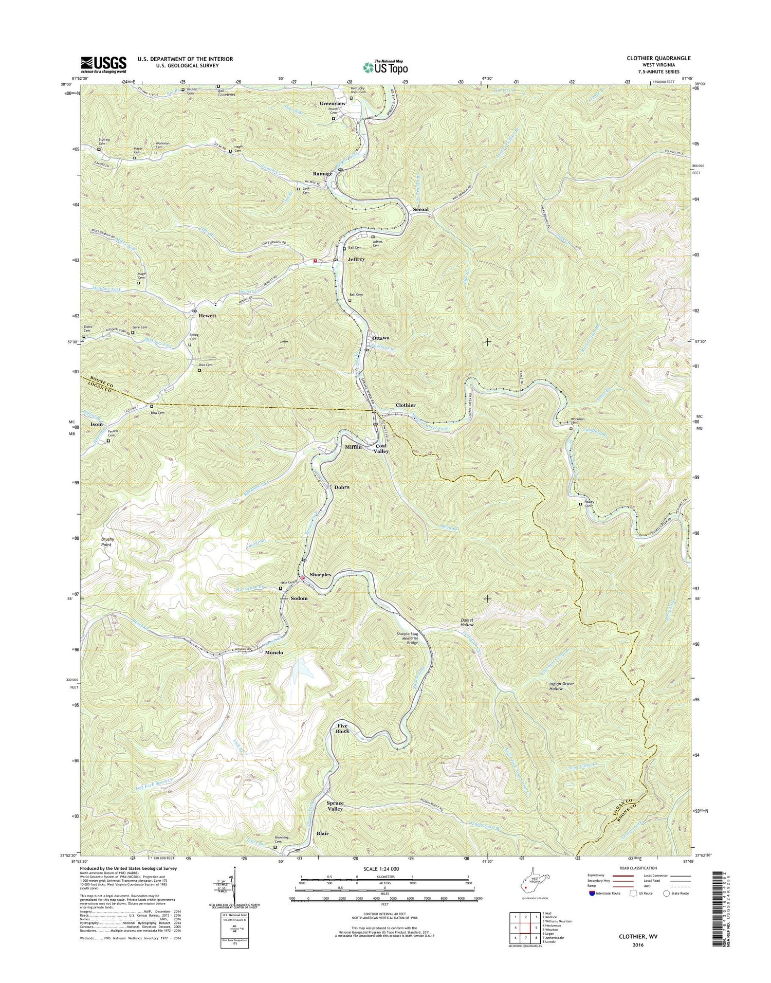
Clothier West Virginia US Topo Map
Couldn't load pickup availability
2023 topographic map quadrangle Clothier in the state of West Virginia. Scale: 1:24000. Based on the newly updated USGS 7.5' US Topo map series, this map is in the following counties: Boone, Logan. The map contains contour data, water features, and other items you are used to seeing on USGS maps, but also has updated roads and other features. This is the next generation of topographic maps. Printed on high-quality waterproof paper with UV fade-resistant inks.
Quads adjacent to this one:
West: Henlawson
Northwest: Mud
North: Madison
Northeast: Williams Mountain
East: Wharton
Southeast: Lorado
South: Amherstdale
Southwest: Logan
This map covers the same area as the classic USGS quad with code o37081h7.
Contains the following named places: Adkins Cemetery, Ball Cemeteries, Ball Cemetery, Ball Chapel, Beech Creek, Bend Branch, Bias Branch, Bias Cemetery, Big Branch, Blair, Blair Post Office, Browning Cemetery, Brushy Point, Burnt Cabin Branch, Chestnut Camp Branch, Clothier, Clothier Post Office, Coal Branch, Coal Valley, Cook Cemetery, Daniel Hollow, Dobra, Elkins Cemetery, Epling Cemetery, Ferrell Cemetery, Five Block, Gore Cemetery, Greenview, Greenview Census Designated Place, Hager Cemetery, Hale Cemetery, Havana, Hewett, Hewett Creek, Hewett Post Office, Hurricane Branch, Indian Grave Hollow, Isom, Jeffrey, Jeffrey - Spencer Elementary School, Jeffrey Post Office, Kentucky Knoll Cemetery, Laurel Branch, Laurel City School, Left Fork Beech Creek, Left Fork Bias Branch, Lick Branch, Meadow Fork, Mifflin, Mikes Fork, Missouri Fork, Monclo, Obes Branch, Oldhouse Branch, Ottawa, Ottawa Post Office, Pauley Cemetery, Pigeonroost Branch, Pigtail Branch, Powell Branch, Powell Cemetery, Ramage, Ramage Elementary School, Ramage Post Office, Right Fork Seng Camp Creek, Rockhouse Creek, Sandford Branch, Secoal, Seng Camp Creek, Sharple Stag Memorial Bridge, Sharples, Sharples High School, Sharples Post Office, Sharples Volunteer Fire Department, Sixmile Creek, Sixmile Creek Church, Sodom, Spencer United Methodist Church, Spruce Laurel Church, Spruce Laurel Fork, Spruce River Volunteer Fire Department Station 500, Spruce School, Spruce Valley, Stolling Cemetery, Stollings Branch, Tan Trough Branch, Trace Branch, Trough Fork, White Oak Branch, Workman Cemetery, ZIP Codes: 25047, 25114, 25149, 25183