MyTopo
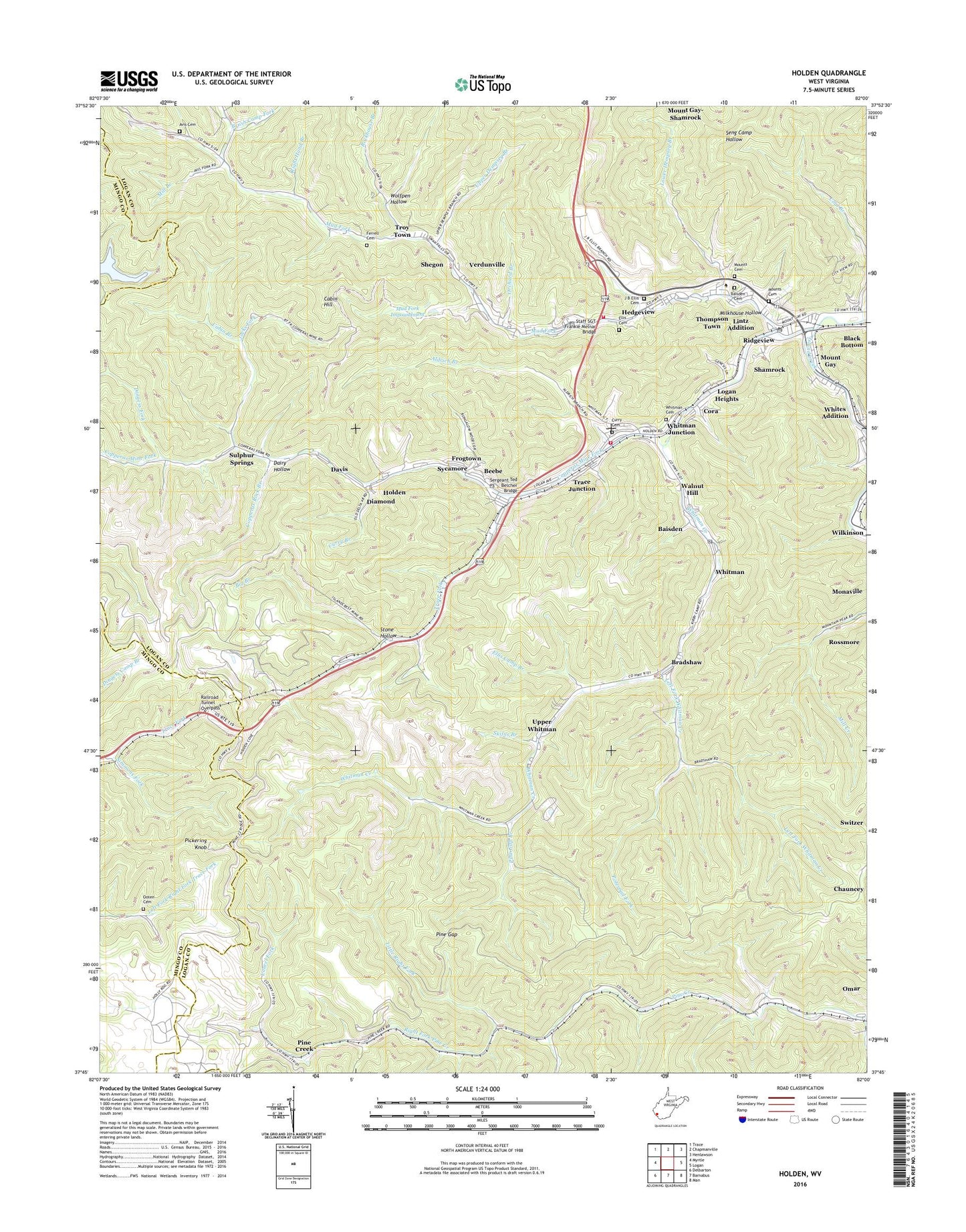
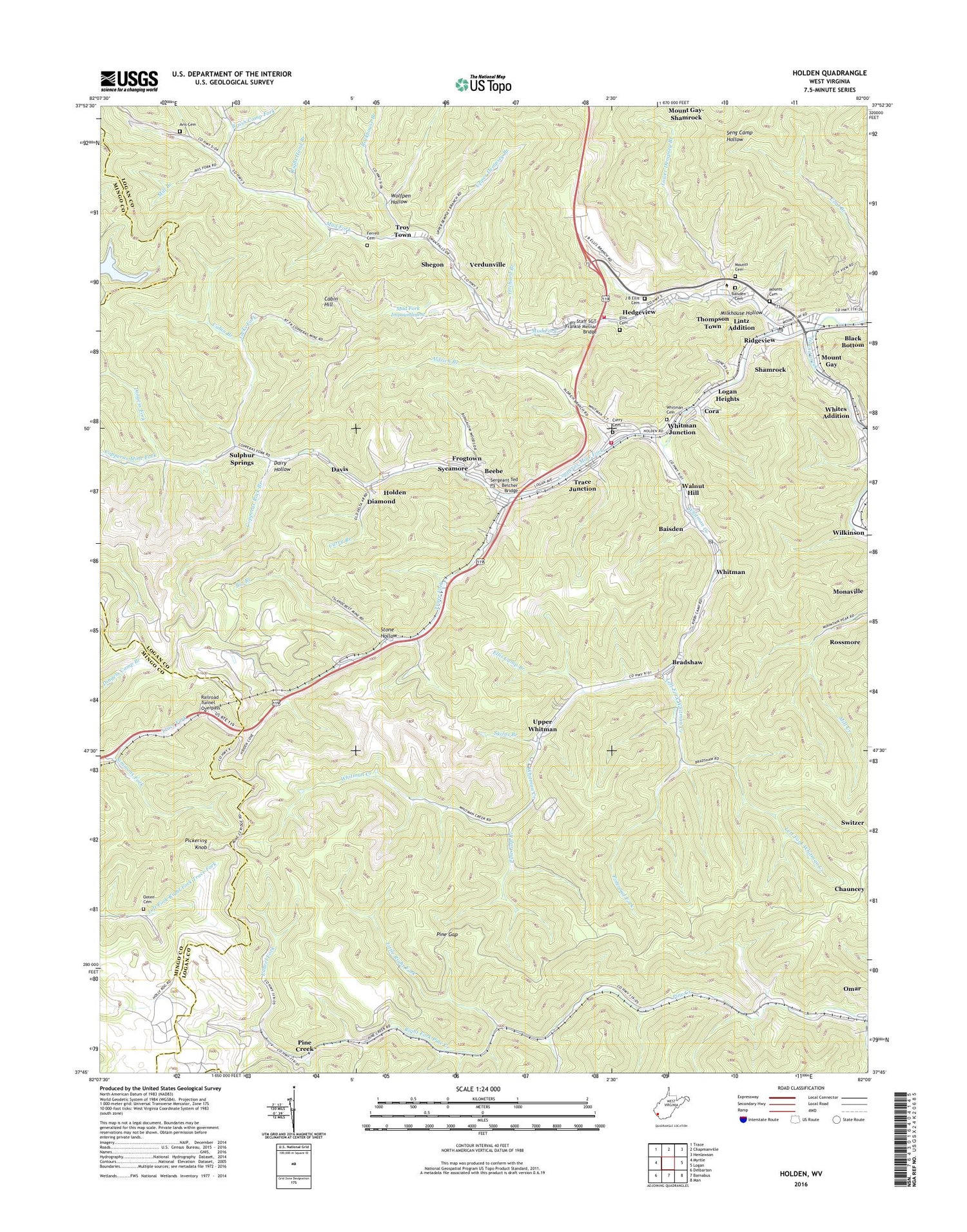
Holden West Virginia US Topo Map
Couldn't load pickup availability
2023 topographic map quadrangle Holden in the state of West Virginia. Scale: 1:24000. Based on the newly updated USGS 7.5' US Topo map series, this map is in the following counties: Logan, Mingo. The map contains contour data, water features, and other items you are used to seeing on USGS maps, but also has updated roads and other features. This is the next generation of topographic maps. Printed on high-quality waterproof paper with UV fade-resistant inks.
Quads adjacent to this one:
West: Myrtle
Northwest: Trace
North: Chapmanville
Northeast: Henlawson
East: Logan
Southeast: Man
South: Barnabus
Southwest: Delbarton
This map covers the same area as the classic USGS quad with code o37082g1.
Contains the following named places: Aldrich Branch, Aracoma High School, Avis Cemetery, Avis School, Baisden, Baisden Cemetery, Beebe, Big Branch, Black Bottom, Bradshaw, Brush Camp Fork, Cabin Branch, Cabin Hill, City View Addition, Coal Miners Chapel, Copperas Mine Fork, Copperas Rock Branch, Copperas School, Cora, Cora Volunteer Fire Department, Curry Branch, Curry Cemetery, Dairy Hollow, Davis, Dempsey Branch Church, Diamond, Dingess Fork, Ellis Branch, Ellis Camp Branch, Ellis Cemetery, Ferrell Cemetery, Frogtown, Harless Library, Hedgeview, Holden, Holden Census Designated Place, Holden Central Elementary School, Holden Post Office, J B Ellis Cemetery, Jacks Fork, Laurel Fork, Left Fork Whitman Creek, Lefthand Branch Mud Fork, Lintz Addition, Little Right Fork, Logan Heights, Logan Holiness International Church, Lower Dempsey Branch, Maryatta Church, Milkhouse Hollow, Mill Branch, Monitor, Monitor Junction, Mount Gay, Mount Gay Post Office, Mount Gay Public School, Mount Gay-Shamrock Census Designated Place, Mount Olive Church, Mounts Cemetery, Mud Fork, Mud Fork Church, Mud Fork Impoundment, Mud Fork Refuse Dam, Number 21 Church, Number 22 Church, Number 7 Church, Ooten Cemetery, Orchard Branch, Pickering Knob, Pickering Knob Lookout Tower, Pine Creek, Pine Creek Church, Pine Gap, Pine Gap Branch, Poleroad Fork, Railroad Tunnel Overpass, Ridgeview, Right Fork Pine Creek, Right Hand Branch, Rockhouse Branch, Saint Marys Catholic Church, Sergeant Ted Belcher Bridge, Shamrock, Shegon, Simmons Fork, Skifus Branch, Southern Mountain Center - Marshall University, Southern West Virginia Community and Technical College - Logan Campus, Southwestern Regional Jail, Staff SGT Frankie Melnar Bridge, Stone Hollow, Sulphur Springs, Sycamore, Thompson Town, Tin Branch, Trace Fork, Trace Junction, Troy Town, United Baptist Church, Upper Dempsey Branch, Upper Whitman, Verdunville, Verdunville Census Designated Place, Verdunville Elementary School, Verdunville Post Office, Verdunville Volunteer Fire Department, Walnut Hill, Western District, Whites Addition, Whitman, Whitman Cemetery, Whitman Church, Whitman Creek, Whitman Junction, Whitman Post Office, Whitman School, Wolfpen Hollow, Yuma School, ZIP Codes: 25601, 25625, 25637, 25652