MyTopo
Matoaka West Virginia US Topo Map
Couldn't load pickup availability
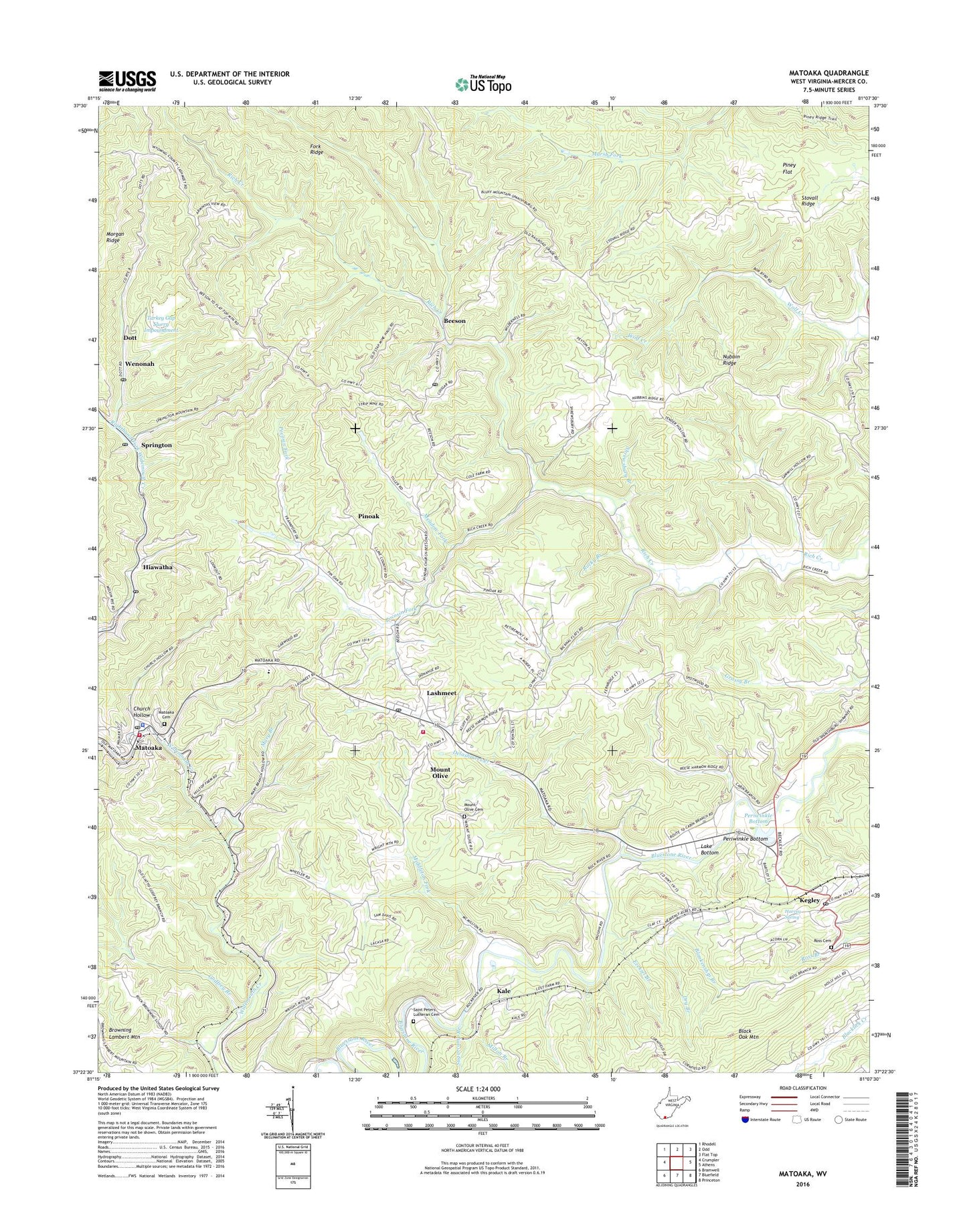
2023 topographic map quadrangle Matoaka in the state of West Virginia. Scale: 1:24000. Based on the newly updated USGS 7.5' US Topo map series, this map is in the following counties: Mercer. The map contains contour data, water features, and other items you are used to seeing on USGS maps, but also has updated roads and other features. This is the next generation of topographic maps. Printed on high-quality waterproof paper with UV fade-resistant inks.
Quads adjacent to this one:
West: Crumpler
Northwest: Rhodell
North: Odd
Northeast: Flat Top
East: Athens
Southeast: Princeton
South: Bluefield
Southwest: Bramwell
This map covers the same area as the classic USGS quad with code o37081d2.
Contains the following named places: Bailey School, Beeson, Beeson Chapel, Beeson Post Office, Blankenship Branch, Cedar Cliff School, Church Hollow, Cooks Chapel, Delashmeet Creek, Dott, Dott Post Office, Dry Branch, Ezekiel Branch, Fork Ridge, Godfrey Branch, Grace Church, Grassy Branch School, Grecian Bend School, Harvey Spring, Hiawatha, Hiawatha Post Office, Kale, Kegley, Kegley Church, Kegley Elementary School, Kegley Post Office, Lake Bottom, Lake Shawnee, Lake View Church, Lashmeet, Lashmeet - Matoaka School, Lashmeet Census Designated Place, Lashmeet Elementary School, Lashmeet Post Office, Mary Branch, Mary Branch Church, Matoaka, Matoaka Cemetery, Matoaka Elementary School, Matoaka High School, Matoaka Police Department, Matoaka Post Office, Matoaka Volunteer Fire Department Station 1, Matoaka Volunteer Fire Department Station 2, Meadow Fork, Michael School, Middleton Fork, Milton Branch, Morgan Ridge, Mount Grove Church, Mount Olive, Mount Olive Cemetery, Mount Olivet United Methodist Church, Nubbin Ridge, Old State Road Church, Periwinkle Bottom, Piney Flat, Pinoak, Pinoak School, Pocosin Fork, Princeton Rescue Squad Station 2, Rich Creek Church, Rich Creek School, Rocky Branch, Ross Cemetery, Saint Peters Lutheran Cemetery, Sand Gap, Sand Gap School, Shrewsbury Branch, Springton, Springton Junior High School, Springton Post Office, Stovall Ridge, Stovall Ridge Church, Sugarcamp Branch, Town of Matoaka, Turkey Gap Mine Refuse Dump Dam, Turkey Gap Slurry Impoundment, Wenonah, Wesley Chapel, Willis White School, Wimmers Trailer Park, ZIP Codes: 24714, 24731, 24733