MyTopo
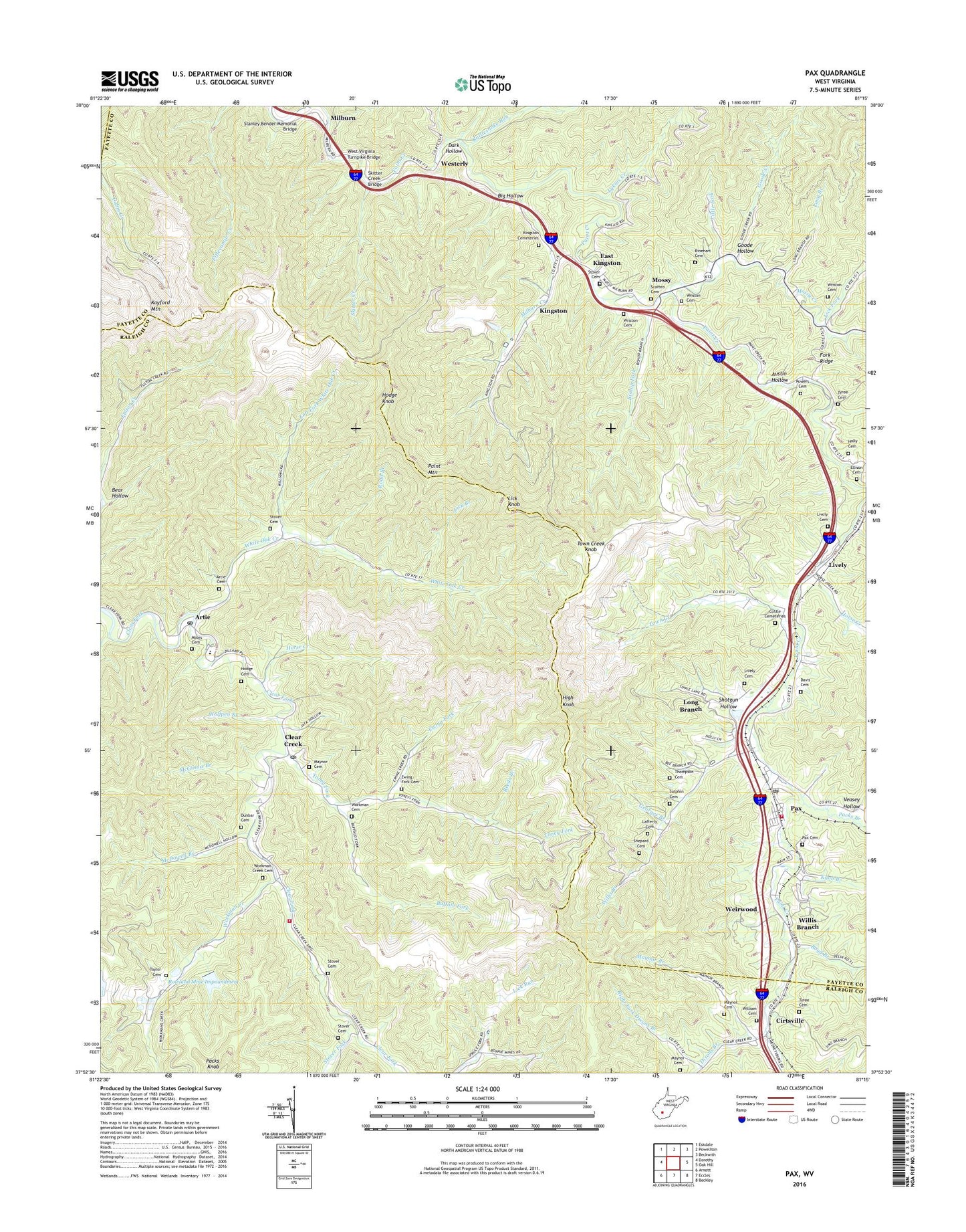
Pax West Virginia US Topo Map
Couldn't load pickup availability
2023 topographic map quadrangle Pax in the state of West Virginia. Scale: 1:24000. Based on the newly updated USGS 7.5' US Topo map series, this map is in the following counties: Fayette, Raleigh, Kanawha. The map contains contour data, water features, and other items you are used to seeing on USGS maps, but also has updated roads and other features. This is the next generation of topographic maps. Printed on high-quality waterproof paper with UV fade-resistant inks.
Quads adjacent to this one:
West: Dorothy
Northwest: Eskdale
North: Powellton
Northeast: Beckwith
East: Oak Hill
Southeast: Beckley
South: Eccles
Southwest: Arnett
This map covers the same area as the classic USGS quad with code o37081h3.
Contains the following named places: Artie, Artie Cemetery, Artie Post Office, Austin Hollow, Bear Hollow, Bee Branch, Big Hollow, Bishop Fork, Boyd Branch, Buffalo Fork, Cirtsville, Clear Creek, Clear Creek Post Office, Clear Creek Volunteer Fire Department, Clear Fork District Elementary School, Collins Fork Impoundment, Cottle Cemeteries, Dark Hollow, Davis Cemetery, District 2, Dixons Branch, Dunbar Cemetery, East Kingston, Ellison Cemetery, Ewing Fork, Ewing Fork Cemetery, Fairview Church, Fork Bottom School, Georges Branch, Goode Creek, Goode Hollow, High Knob, Hodge Cemetery, Hodge Knob, Holly Cemetery, Horse Creek, Kingston, Kingston Cemeteries, Knob Branch, Lafferty Cemetery, Laurel Grove Baptist Church, Left Fork White Oak Creek, Lick Branch, Lick Fork, Lick Fork School, Lick Knob, Lick Knob Lookout Tower, Little Fork, Lively, Lively Cemetery, Long Branch, Long Branch Church, Lykins Creek, Maynor Branch, Maynor Cemetery, McDowell Branch, McGinnis Branch, Mcgraw Fork Slurry Dam, Milburn, Milburn Creek, Moles Cemetery, Mossy, Mossy Church, Mossy Creek, Packs Branch, Paint Mountain, Pax, Pax Cemetery, Pax Elementary School, Pax Post Office, Pax Volunteer Fire Department, Plum Orchard Creek, Powers Cemetery, Rattlesnake Run, Reeds Branch, Right Fork Dixons Branch, Rinehart Cemetery, Road Branch, Roseville, Roseville Church, Rowland Mine Impoundment, Scarbro Cemetery, Shepard Cemetery, Shotgun Hollow, Skitter Creek, Skitter Creek Bridge, Skitter Creek Dam, Spruce Tabernacle, Stanley Bender Memorial Bridge, Stover Cemetery, Stover Fork, Stover School, Sutphin Cemetery, Taylor Cemetery, Thompson Cemetery, Toney Fork, Toney Fork Church, Toney Fork School, Town Creek, Town Creek Knob, Town of Pax, Tyree Cemetery, Unnamed Tributary of Plum Orchard Creek Dam, Veasey Hollow, WCIR-FM (Beckley), Weirwood, West Virginia Turnpike Bridge, Westerly, White Oak Creek, Whiteoak School, William Cemetery, Willis Branch, Wolfpen Branch, Workman Cemetery, Workman Creek, Workman Creek Cemetery, Workman Creek Church, Workman Creek School, Wriston Cemetery, ZIP Codes: 25008, 25044, 25904