MyTopo
Pocatalico West Virginia US Topo Map
Couldn't load pickup availability
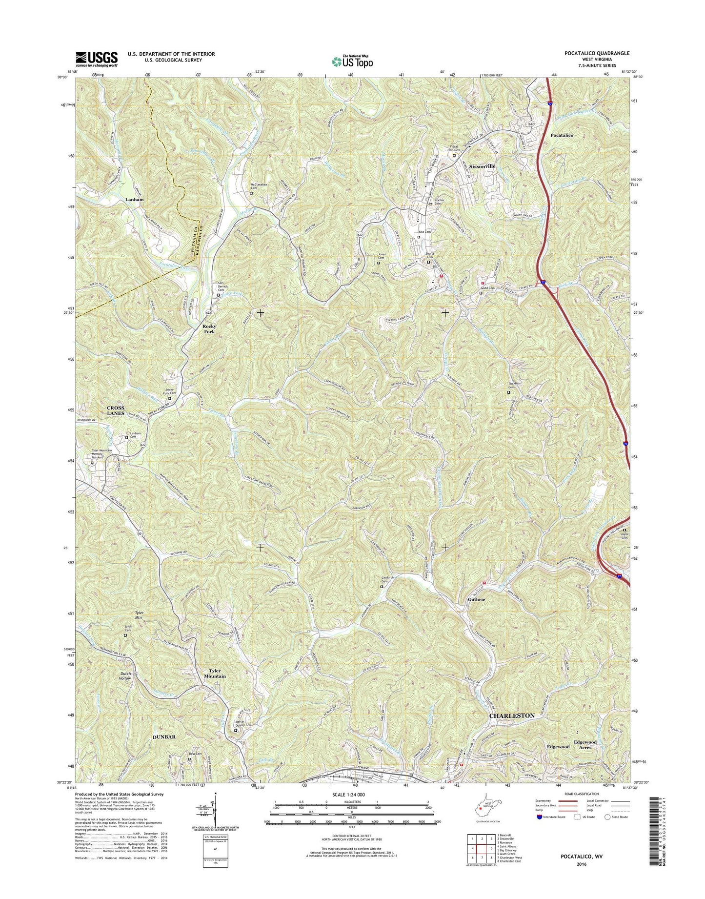
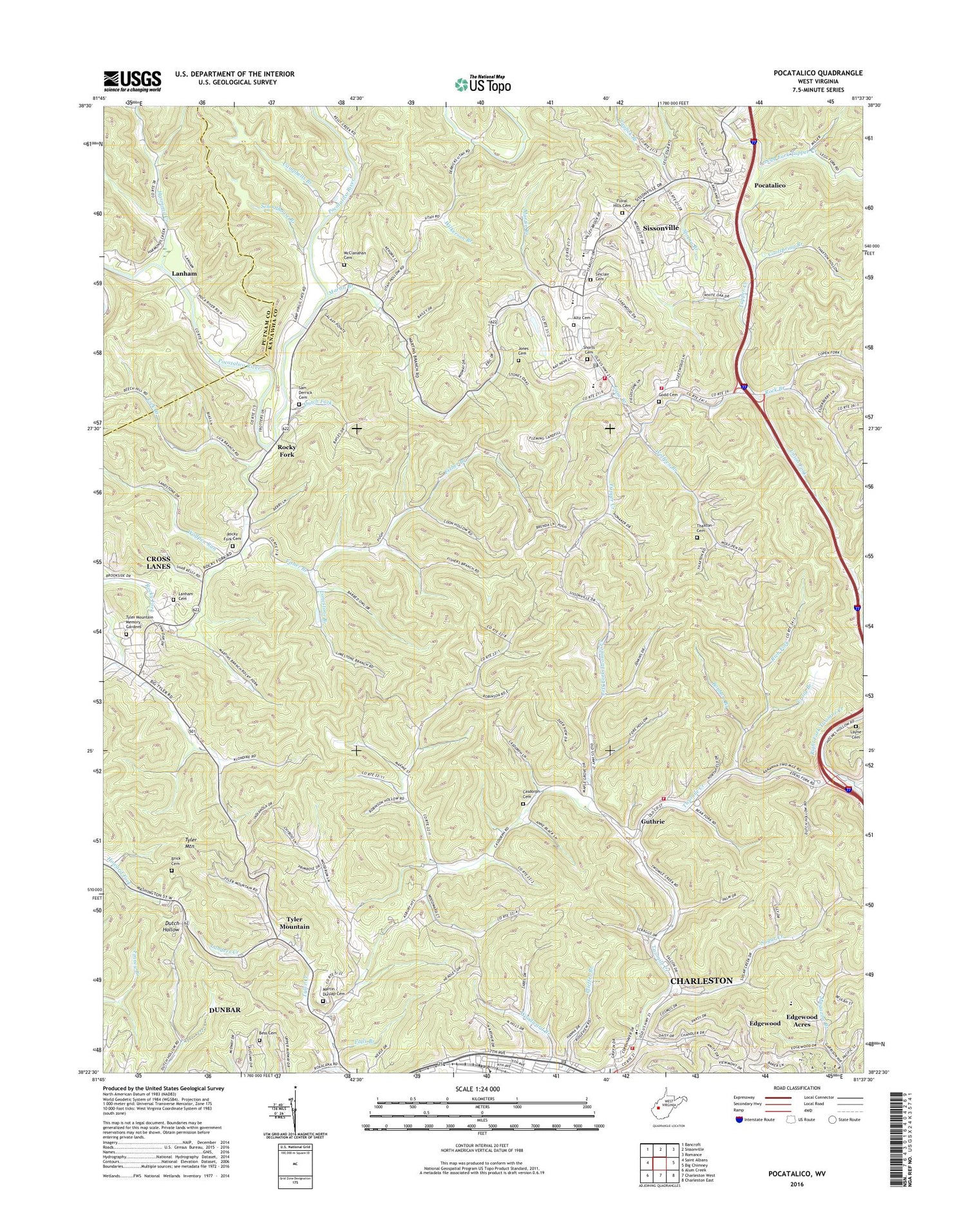
2019 topographic map quadrangle Pocatalico in the state of West Virginia. Scale: 1:24000. Based on the newly updated USGS 7.5' US Topo map series, this map is in the following counties: Kanawha, Putnam. The map contains contour data, water features, and other items you are used to seeing on USGS maps, but also has updated roads and other features. This is the next generation of topographic maps. Printed on high-quality waterproof paper with UV fade-resistant inks.
Quads adjacent to this one:
West: Saint Albans
Northwest: Bancroft
North: Sissonville
Northeast: Romance
East: Big Chimney
Southeast: Charleston East
South: Charleston West
Southwest: Alum Creek
Contains the following named places: Aetna School, Aetna-Dell School, Altz Cemetery, Atkinson School, Barbe School, Bess Cemetery, Bethel Church, Bias Chapel, Bible Baptist Christian School, Bonham Branch, Bonham Elementary School, Booker T Washington State Park, Brick Cemetery, Brown Church, Brush School, Buena Vista School, Camp Virgil Tate, Campbells Branch, Casdorph Cemetery, Cato Park, Chandler Elementary School, Charleston Fire Department Station 8, Claylick Branch, Community Gospel Church, Community Mission Church, Conquerors Christian School, Coolspring Branch, Craig Branch, Dutch Fork, Edens Fork, Edgewood, Edgewood Acres, Edgewood Country Club, Fairview Church, Faith Tabernacle Church, Falls Branch, Fisher Branch, Flinn Elementary School, Floral Hills Garden of Memories Cemetery, Godd Cemetery, Grandview Elementary School, Greenlee Chapel, Guthrie, Guthrie Air Force Station, Hannah Drive Church, Harmond Creek, Harper Memorial Church, Holiness Church of Christ, Jones Cemetery, Kanawha County Emergency Ambulance Authority Station 269, Kanawha County Sheriff's Office - Sissonville Detachment, Landers Creek, Lane Branch, Lanham, Lanham Cemetery, Layne Cemetery, Left Fork Twomile Creek, Legg Fork Tupper Creek, Leggs Memorial Church, Liberty Church, Lick Branch, Limestone Branch, Littlepage Church, Littlepage School, Lowland School, Martin / Dunlap Cemetery, Martin Branch, Martin Branch School, Mcclanahan Cemetery, McKinnon Church, Meyers School, Morgan Chapel, Morning Star School, North Side Church of the Nazarene, Parsons School, Pleasant Dell School, Pocatalico, Rich Fork, Right Fork Twomile Creek, Robson Presbyterian Church, Rock Branch, Rocky Fork, Rocky Fork Cemetery, Saint James Episcopal Church, Sam Derrick Cemetery, Schoolhouse Branch, Sheldon Rock Branch, Shorts Cemetery, Sinclair Cemetery, Sissonville High School, Sissonville Middle School, Sissonville Millertown Pocatalico and Guthrie Volunteer Fire Department Huston Station, Sissonville Millertown Pocatalico and Guthrie Volunteer Fire Department Johnson Station, Sissonville Millertown Pocatalico and Guthrie Volunteer Fire Department Loftis Station, Sissonville Post Office, Sissonville Public Library, Sliphill School, Spring Branch, Starcher Baptist Church, Station C Post Office, Sugar Creek, Sugar Creek Missionary Baptist Church, Sugar Creek School, Thaxton Cemetery, Thompson Chapel, Tupper Valley Church, Tupper Valley Gospel Tabernacle, Tyler Elementary School, Tyler Middle School, Tyler Mountain, Tyler Mountain Memory Gardens, Union Fork, Union School, Utah Church, Walker Church, Wallace, Wallace Heights School, WBES-FM (Dunbar), West Virginia Division of Forestry Kanawha County Field Office, Wilkerson Branch, WJYP-FM (South Charleston), Wolfpen Branch, Wolfpen Run, Woodward Woods Church, WQBE-AM (Charleston), WQBE-FM (Charleston), WSCW-AM (South Charleston), WTUN-FM (Pocatalico), WVPN-FM (Charleston), ZIP Codes: 25064, 25312