MyTopo
Charleston East West Virginia US Topo Map
Couldn't load pickup availability
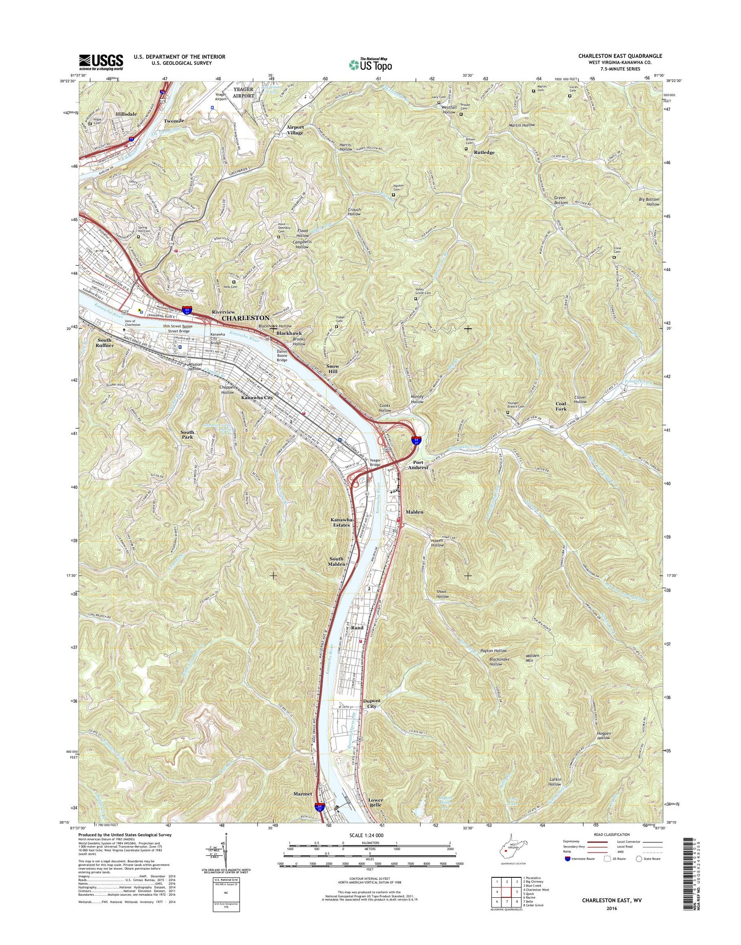
2023 topographic map quadrangle Charleston East in the state of West Virginia. Scale: 1:24000. Based on the newly updated USGS 7.5' US Topo map series, this map is in the following counties: Kanawha. The map contains contour data, water features, and other items you are used to seeing on USGS maps, but also has updated roads and other features. This is the next generation of topographic maps. Printed on high-quality waterproof paper with UV fade-resistant inks.
Quads adjacent to this one:
West: Charleston West
Northwest: Pocatalico
North: Big Chimney
Northeast: Blue Creek
East: Quick
Southeast: Cedar Grove
South: Belle
Southwest: Racine
This map covers the same area as the classic USGS quad with code o38081c5.
Contains the following named places: 35th Street Bridge, 36th Street Bridge, African Zion Baptist Church, Airport School, Airport Village, Allen Chapel African Methodist Episcopal Church, Alpha School, Andrew S Thomas Memorial Library, Asbury United Methodist Church, Atkisson Dam Lighthouse, Baker Fork, Benedum Hall, Bethany Baptist Church, Blackhawk, Blackhawk Hollow, Blacksnake Hollow, Blackwell Field, Bnai Israel Temple, Bnai Jacob Synagogue, Brooks Hollow, Brookside Childrens Home, Brown Cemetery, Burning Spring Branch, CAMC Memorial Helistop - ground level, Campbells Creek, Campbells Hollow, Capital High School, Capital View Church of the Nazarene, Carl Woods Spring, Carver Career Center, Chamberlain Elementary School, Chappel Branch, Chappell Hollow, Charleston Area Medical Center Memorial Hospital, Charleston Fire Department Station 4, Charleston Fire Department Station 6, Charleston Fire Department Station 7, Church of Christ, Church of God, Church of the Nazarene, Cline Cemetery, Clover Hollow, Coal Fork, Coal Fork Census Designated Place, Coal Fork Post Office, Coal Fork United Methodist Church, Columbia Carbon Company Spring, Cooks Hollow, Cool Lake, Cox Hall, Crouch Hollow, Daniel Boone Bridge, Daniel Boone Park, Dickinson Hall, Dry Branch, Du Pont High School, Du Pont Middle School, Dupont City, Dupont City Census Designated Place, Dupont Waste Lake, East End Historic District, East Point Apostolic Church, Elk Twomile Creek, Elk Twomile Creek Structure Number 13 Dam, Elk Twomile Structure Number 12 Dam, Elm Grove, Fairhaven Christian School, First Assembly of God Church, First Christian Church, Fisher Cemetery, Flood Hollow, Georges Creek, Gill Hollow, Green Bottom, Green Bottom School, Hanson Branch, Hanson Cemetery, Harris Hollow, Hawes Hollow, Healthnet II Ambulance, Hess Cemetery, Highland Hospital, Hillcrest Office Park, Hillcrest Sanitarium, Hillsdale, Hogpen Hollow, Holly Grove, Hope Cemetery, Horace Mann Middle School, Hubbard School, Hunt - Donnally Cemetery, Kanawha City, Kanawha City Baptist Church, Kanawha City Bridge, Kanawha City Elementary School, Kanawha City Post Office, Kanawha County, Kanawha County Schools Academy, Kanawha Estates, Kanawha Mall Shopping Center, Kanawha Riflemens Memorial Park, Kanawha Salines Presbyterian Church, Kanawha School, Kelly Branch, Lacy Cemetery, Laidley Field, Larkin Hollow, Left Fork Spring Fork, Levi Church, Liberty Baptist Church, Lick Branch, Little Spring Fork, Lock 5, Lower Belle, Lower Donnally Branch, Lucas Cemetery, Magazine Branch, Malden, Malden Baptist Church, Malden Census Designated Place, Malden Elementary School, Malden Methodist Episcopal Church, Malden Mountain, Malden Post Office, Malden Volunteer Fire Department, Maple Hill Church, Marmet Locks, Marmet Locks and Dam, Martin Cemetery, Martin Hollow, Martin School, McGwiggan Public School, Midway Elementary School, Mission Hollow, Morris Memorial United Methodist Church, Mount Calvary Baptist Church, Mountaineer Montessori School, Nunley Hollow, Oak Ridge School, Oakridge Bible Church, Owens Industrial Park, Owens School, Payton Hollow, Pentecostal Holiness Church, Plaza East Shopping Center, Pointlick Church, Pointlick Fork, Port Amherst, Prouse Cemetery, Rand, Rand Census Designated Place, Rand Elementary School, Rand Post Office, Rand Volunteer Fire Department, Right Fork Coal Fork, Right Fork Rush Creek, Riverview, Riverview Baptist Church, Riverview School, Roosevelt Junior High School, Ruffner Elementary School, Ruffner Hollow, Ruffner Memorial Presbyterian Church, Rush Creek, Rutledge, Saint Agnes Roman Catholic Church, Saint Agnes School, Saint John Greek Orthodox Church, Scotts Run Cinder Barrier Dam, Shoot Hollow, Simmons Creek School, Snow Hill, South Malden, South Park, South Park School, South Ruffner, South Ruffner Presbyterian Church, Southeast Church of the Nazarene, Spring Fork, Spring Hill Cemetery, Spring Hill Cemetery Historic District, Sunset School, Taft Elementary School, Trinity Evangelical Lutheran Church, Twomile, University of Charleston, University of Charleston Department of Public Safety and Security, Upper Donnally Branch, Valley Grove Branch, Valley Grove Cemetery, Valley Grove Elementary School, Venable Branch, Vernon Cobb Hall, Village Chapel Presbyterian Church, Walnut Gap School, Walt Powell Park, Wash Branch, Watt Powell Stadium, WCAW-AM (Charleston), WCZR-AM (Charleston), Wesley United Methodist Church, West Virginia Air National Guard 130th Airlift Wing Fire Department Yeager Airport, West Virginia Archives and History Division Library, West Virginia Division of Protective Services Capitol Police Department, West Virginia Legislative Reference Library, West Virginia State Capitol, West Virginia State Museum, Westfall Hollow, Westminster Presbyterian Church, WLZT-FM (Miami), WVAF-FM (Charleston), WVNS-FM (Charleston), WYQC-FM (Charleston), Yeager Airport, Yeager Airport Police Department, Yeager Bridge, Younger Branch, Younger Branch Cemetery, ZIP Codes: 25304, 25305, 25311