MyTopo
Wolf Summit West Virginia US Topo Map
Couldn't load pickup availability
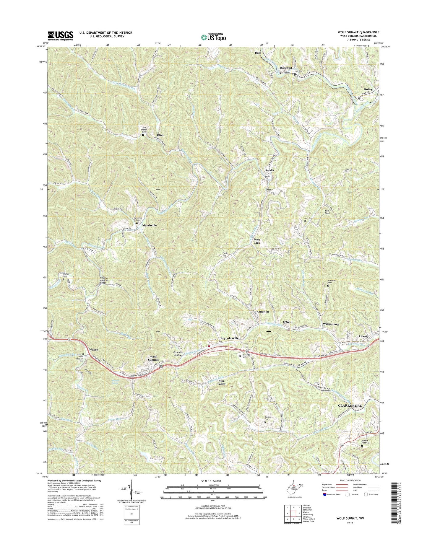
2023 topographic map quadrangle Wolf Summit in the state of West Virginia. Scale: 1:24000. Based on the newly updated USGS 7.5' US Topo map series, this map is in the following counties: Harrison. The map contains contour data, water features, and other items you are used to seeing on USGS maps, but also has updated roads and other features. This is the next generation of topographic maps. Printed on high-quality waterproof paper with UV fade-resistant inks.
Quads adjacent to this one:
West: Salem
Northwest: Folsom
North: Wallace
Northeast: Shinnston
East: Clarksburg
Southeast: Mount Clare
South: West Milford
Southwest: Big Isaac
This map covers the same area as the classic USGS quad with code o39080c4.
Contains the following named places: Ash Cemetery, Bethlehem Baptist Church, Borring Cemetery, Catfish School, Chieftain School, Chiefton, Coplin Church, Crooked Run School, Davis School, Davisson Run Church, Elliott School, Flag Run, Flagg Run School, Fletcher Covered Bridge, Flowers Spring, Grass Run, Gregory Run, Gregory Run School, Hall Cemetery, Halls Run, Hannah School, Hardman Cemetery, Harrison County, Indian Run, Isaac Creek, Isaac Creek School, Isaacs Creek Baptist Church, Johnson Fork, Katy Lick, Katy Lick Run, Laurel Run, Laurel Run School, Left Prong New Creek, Liberty, Liberty High School, Lick Run, Little Isaac Creek, Little Rockcamp Run, Little Tenmile Creek, Lower Davisson Run School, Maken, Marshville, Marshville Baptist Church, Marshville Cemetery, Milford Road Cemetery, Morrison Chapel, Mount Hope Church, Mountaineer Middle School, New Creek, North Urban District, Olive, Olive Branch Baptist Church, Olive Branch Cemetery, O'Neill, Peters Run, Phoenix Hollow, Plant Cemetery, Point Pleasant Cemetery, Point Pleasant Church, Reynolds Cemetery, Reynoldsville, Reynoldsville Baptist Church, Reynoldsville Census Designated Place, Reynoldsville Post Office, Reynoldsville Volunteer Fire Department, Right Prong New Creek, Robey, Rockcamp Run, Rosebud, Rush Run, Ruth Field, Salem Fork, Sandhill School, Sardis, Sardis Cemetery, Sardis High School, Shahan Cemetery, Shahan School, Shaws Run, Simpson Fork, Smith School, South Urban District, Sun Valley, Sunny Croft Country Club Golf Course, Tenmile Baptist Church, Tenmile Community Center, Turkey Foot Run, Upper Davisson Run School, Washburncamp Run, Wilsonburg, Wilsonburg Elementary School, Wizardism Run, WOBG-FM (Salem), Wolf Summit, Wolf Summit Census Designated Place, Wolf Summit Methodist Church, Wolf Summit Post Office, Wolfpen Run, WZWA-FM (Clarksburg), ZIP Codes: 26301, 26422