MyTopo
Burlington Wisconsin US Topo Map
Couldn't load pickup availability
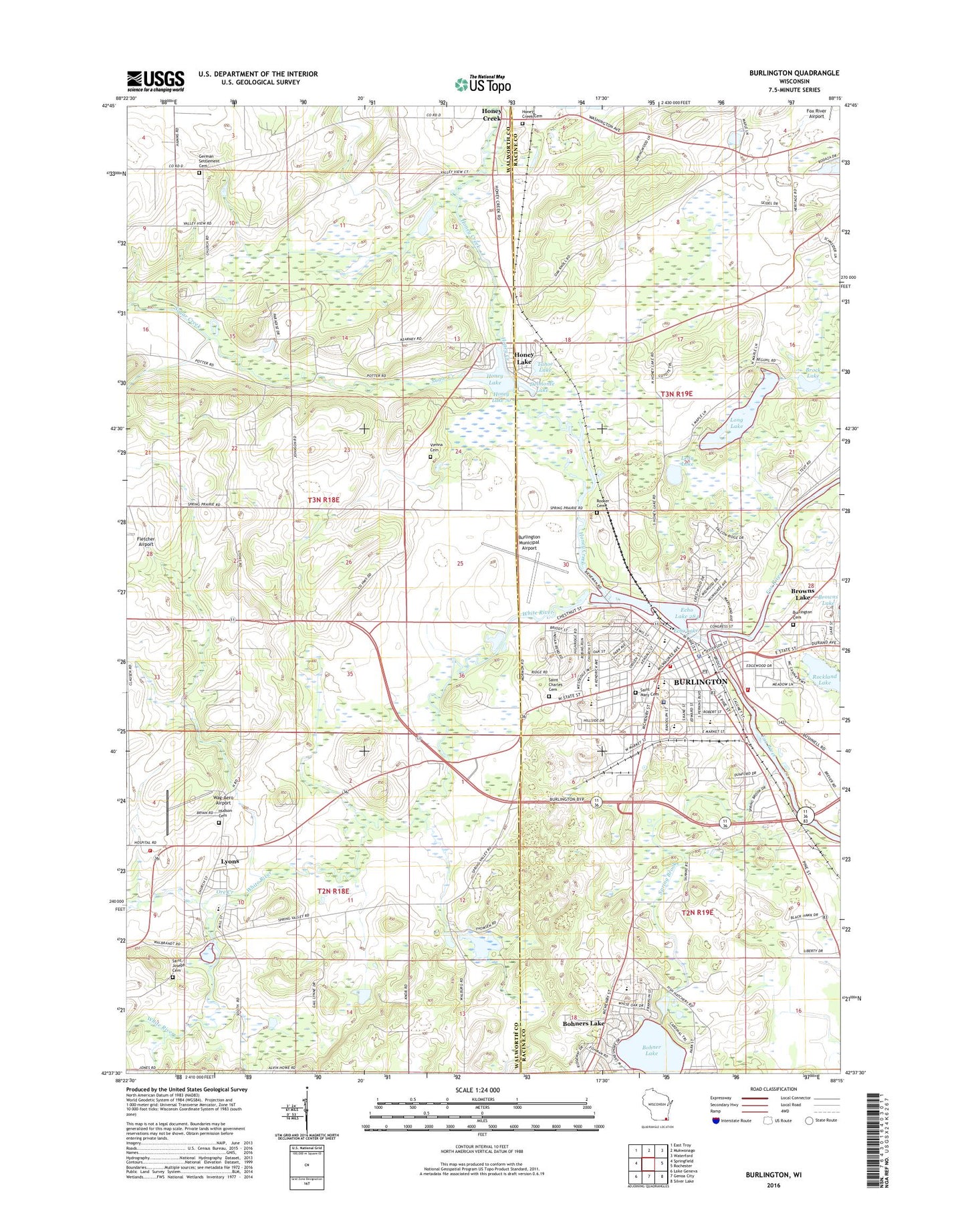
2022 topographic map quadrangle Burlington in the state of Wisconsin. Scale: 1:24000. Based on the newly updated USGS 7.5' US Topo map series, this map is in the following counties: Walworth, Racine. The map contains contour data, water features, and other items you are used to seeing on USGS maps, but also has updated roads and other features. This is the next generation of topographic maps. Printed on high-quality waterproof paper with UV fade-resistant inks.
Quads adjacent to this one:
West: Springfield
Northwest: East Troy
North: Mukwonago
Northeast: Waterford
East: Rochester
Southeast: Silver Lake
South: Genoa City
Southwest: Lake Geneva
This map covers the same area as the classic USGS quad with code o42088f3.
Contains the following named places: Aurora Memorial Hospital of Burlington, Beaumont Field, Benson Park, Bethel Baptist Church, Bohner Lake, Brock Lake, Browns Lake Golf Course, Burlington, Burlington 2WP311 Dam, Burlington Cemetery, Burlington City Hall, Burlington Fire Department, Burlington High School, Burlington Municipal Airport, Burlington Police Department, Burlington Post Office, Burlington Public Library, Burlington Rescue Squad, Burlington Township Police Department, Burlington Township Volunteer Fire Department, Burlington Water Works, Bushnell Park, Camp MacLean, Catholic Central High School, City of Burlington, Cooper Elementary School, Cornerstone Christian Academy, Cross Evangelical Lutheran Church, Delmonte Lake, Devor Park, Diener Cemetery, Doctor Edward G Dyer School, Echo Lake, Echo Veterans Memorial Park, First Church of Christ Scientist, First Methodist Church, Fletcher Airport, German Settlement Cemetery, German Settlement Church, Grove Street Park, Highridge Park, Honey Creek, Honey Creek Cemetery, Honey Creek Post Office, Honey Lake, Honey Lake WP276 Dam, Hudson Cemetery, Leda Lake, Limestone Quarry Number 3, Lincoln School, Long Lake, Luther Hall, Lyons, Lyons Census Designated Place, Lyons Center School, Lyons Fire Department, Lyons Post Office, McCanna Park, Medix Ambulance Service, Meinhardt Park, Motors Mobile Home Park, Nestles Park, Nettie E Karcher School, Ore Creek, Our Savior Lutheran Church, Pleasant View School, Plymouth Congregational Church, Riverside Park, Rockland Lake, Rooker Cemetery, Saint Charles Catholic Church, Saint Charles Cemetery, Saint Charles School, Saint Johns Episcopal Church, Saint Johns Evangelical Lutheran Church, Saint John's Lutheran School, Saint Joseph Cemetery, Saint Mary Cemetery, Saint Marys Catholic Church, Saint Mary's School, Schamling Park, Spring Brook, Steinhoff Park, Sugar Creek, Sunset Park, Tahoe Lake, Town of Lyons, Town of Spring Prairie, Wag-Aero Airport, Wagner Park, Waller Elementary School, Warren Pit, Water Tower Park, WBSD-FM (Burlington), Wehmhoff Jucker Park, Wehmhoff Square, White River, Winkler Elementary School, ZIP Code: 53105