MyTopo
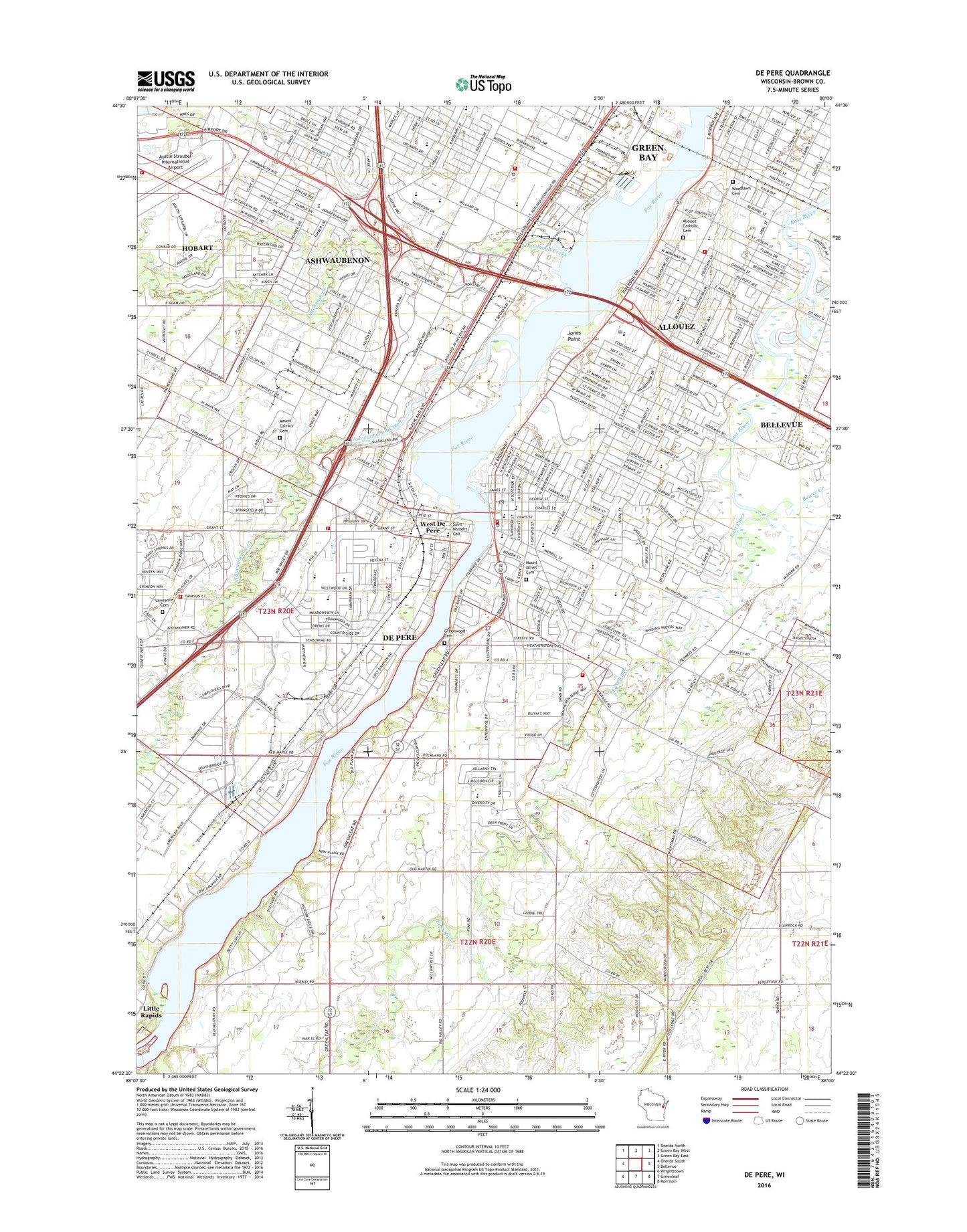
De Pere Wisconsin US Topo Map
Couldn't load pickup availability
2018 topographic map quadrangle De Pere in the state of Wisconsin. Scale: 1:24000. Based on the newly updated USGS 7.5' US Topo map series, this map is in the following counties: Brown. The map contains contour data, water features, and other items you are used to seeing on USGS maps, but also has updated roads and other features. This is the next generation of topographic maps. Printed on high-quality waterproof paper with UV fade-resistant inks.
Quads adjacent to this one:
West: Oneida South
Northwest: Oneida North
North: Green Bay West
Northeast: Green Bay East
East: Bellevue
Southeast: Morrison
South: Greenleaf
Southwest: Wrightstown
Contains the following named places: 1 Reservoir, 54115, 54301, 54304, 54307, 6322 Reservoir, 6336 Reservoir, Abbot Pennings High School, Allouez, Allouez Catholic Cemetery, Allouez Department of Public Safety, Allouez Park, Allouez School, Apple Valley Orchard, Ascension Lutheran Church, Ashwaubenon, Ashwaubenon Creek, Ashwaubenon Department of Public Safety Fire Station, Ashwaubenon Department of Public Safety Police Department, Ashwaubenon High School, Ashwaumobay Memorial Park, Astor Park, Babcock School, Bay Park Square Shopping Center, Bellin Psychiatric Center, Beth Haven Academy, Boulanger Quarry, Bower Creek, Brown County Fair Grounds, Camp Smith, City of De Pere, Cooke Park, Cormier School and Early Learning Center, Creekside Christian Montessori School, De Pere, De Pere Branch Brown County Library, De Pere Dam, De Pere Fire and Rescue Station 2, De Pere Fire Department, De Pere High School, De Pere Middle School, De Pere Police Department, De Pere Post Office, De Pere Wastewater Treatment Plant, Depere Dam, Dickinson Elementary School, Doty Elementary School, Dutchman Creek, East River Valley School, Empire Beauty School - Green Bay, Faith Lutheran Church, First Congregational Church, First Presbyterian Church, Fort Howard Park, Foxair Seaplane Base, Foxview Intermediate School, Francis H Boyle Hall, Green Bay Correctional Institution, Green Bay Correctional Institution School, Green Bay Fire Department Station 8, Green Bay Montessori Children's World, Greenwood Cemetery, Hansen Road Post Office, Hemlock Creek, Heritage Elementary School, Heritage Hill State Park, Hickory Grove Sanatorium, Hopp Elementary - Secondary School, Irwin School, Jones Point, Klipstine School, Langlade Elementary School, Lawrence Cemetery, Lawrence Township Fire Department 2, Ledgeview Fire Department 2, Legion Park, Lincoln School, Little Kaukauna Dam, Little Kaukauna Lock and Dam, Lost Dauphin State Park, Minahan Stadium, Mount Calvary Cemetery, Mount Olivet Cemetery, National Railroad Museum, Nativity School, Notre Dame of de Pere School, Our Lady of Lourdes Catholic School, Park View School, Parkview Middle School, Phantom Knight School of Opportunity, Pioneer Elementary School, Pouwels 3lM79802 Dam, Resurrection Catholic School, River View Mobile Home Park, Royal Montessori Academy, Saint Annes Episcopal Church, Saint Boniface Roman Catholic Church, Saint Boniface School, Saint Francis Xaviers Roman Catholic Church, Saint Johns Lutheran Church, Saint Josephs Roman Catholic Church, Saint Josephs School, Saint Marys Roman Catholic Church, Saint Matthew School, Saint Matthews Roman Catholic Church, Saint Michael Chapel, Saint Norbert Abbey, Saint Norbert College, Smith Park, Susie C Altmayer Elementary School, Town of Rockland, Valley View Elementary School, Veterans of Foreign Wars Park, Village of Allouez, Village of Ashwaubenon, WBAY-TV (Green Bay), Webster Elementary School, West De Pere, West de Pere High School, West de Pere Middle School, Westwood Elementary School, WFRV-TV (Green Bay), WGEE-AM (Green Bay), Wisconsin International School, Wisconsin State Reformatory, WIXX-FM (Green Bay), WNFL-AM (Green Bay), Woodlawn Cemetery, WPNE-FM (Green Bay), WPNE-TV (Green Bay)