MyTopo
Saint Croix Dalles Wisconsin US Topo Map
Couldn't load pickup availability
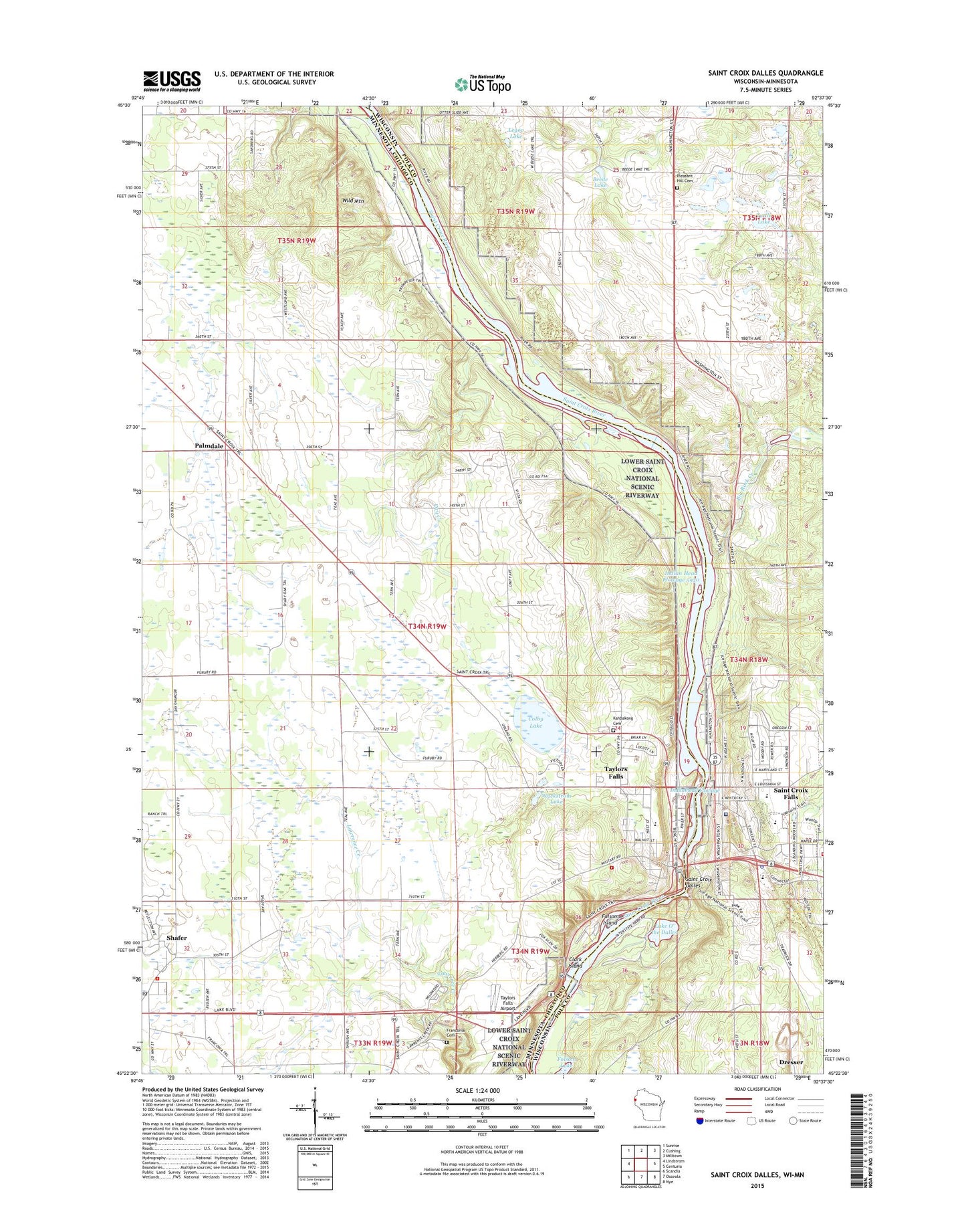
2019 topographic map quadrangle Saint Croix Dalles in the states of Minnesota, Wisconsin. Scale: 1:24000. Based on the newly updated USGS 7.5' US Topo map series, this map is in the following counties: Polk, Chisago. The map contains contour data, water features, and other items you are used to seeing on USGS maps, but also has updated roads and other features. This is the next generation of topographic maps. Printed on high-quality waterproof paper with UV fade-resistant inks.
Quads adjacent to this one:
West: Lindstrom
Northwest: Sunrise
North: Cushing
Northeast: Milltown
East: Centuria
Southeast: Nye
South: Osceola
Southwest: Scandia
Contains the following named places: Alliance Church of the Valley, Beede Lake, Beskar Airport, Big Rock Creek, Camp Waub-O-Jeeg, Centennial Bedrock Glade State Natural Area, Chisago Lakes School, City of Saint Croix Falls, City of Taylors Falls, Clark Island, Colby Lake, Dalles of the Saint Croix River State Natural Area, Dry Creek, First Baptist Church, First Evangelical Lutheran Church, Folsom House Historical Marker, Folsom Island, Franconia Cemetery, Franconia Sculpture Park, Geology of the Taylor Falls Region Historical Marker, Glacial Potholes Historical Marker, Indianhead Flowage, Interstate Lowland Forest State Natural Area, Interstate State Park, Kahbakong Cemetery, Lake O' the Dalles, Legoo Lake, Lions Park, Palmdale, Palmdale Post Office, Pleasant Hill Cemetery, Pleasant Hill Church, Redfield Court Mobile Home Park, Rock Creek Church, Saint Croix Dalles, Saint Croix Falls, Saint Croix Falls 1903-C24 Dam, Saint Croix Falls Elementary School, Saint Croix Falls High School, Saint Croix Falls Hydro Generating Station, Saint Croix Falls Middle School, Saint Croix Falls Police Department, Saint Croix Falls Post Office, Saint Croix Falls Volunteer Fire Department, Saint Croix Regional Medical Center, Saint Joseph Church, Shafer, Shafer / Franconia Fire Department, Shafer Post Office, South Terrace Mobile Home Park, State Entry Sign (New) US 8 Wayside Park, State Entry Sign (Old) US 8 Wayside Park, Taylor Falls Overlook - South, Taylor Falls Wayside Park, Taylors Falls, Taylors Falls Airport, Taylors Falls Elementary School, Taylors Falls Fire Department, Taylors Falls Post Office, Taylors Falls Public Library, Township of Shafer, Tuttle Lake, Wild Mountain, Wild Mountain Ski Area Water Park, Wildwood RV Park Cempground, Wyckstrom Lake, ZIP Codes: 55074, 55084