MyTopo
Concord Alabama US Topo Map
Couldn't load pickup availability
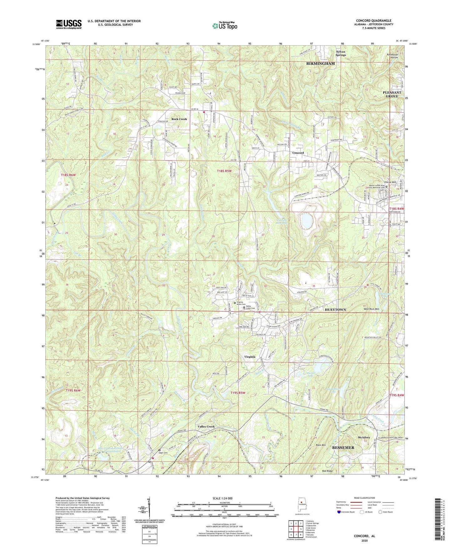
2024 topographic map quadrangle Concord in the state of Alabama. Scale: 1:24000. Based on the newly updated USGS 7.5' US Topo map series, this map is in the following counties: Jefferson. The map contains contour data, water features, and other items you are used to seeing on USGS maps, but also has updated roads and other features. This is the next generation of topographic maps. Printed on high-quality waterproof paper with UV fade-resistant inks.
Quads adjacent to this one:
West: Oak Grove
Northwest: Gilmore
North: Sylvan Springs
Northeast: Adamsville
East: Bessemer
Southeast: Greenwood
South: McCalla
Southwest: Abernant
This map covers the same area as the classic USGS quad with code o33087d1.
Contains the following named places: Adger, Adger Cemetery, Adger Fire Department, Adger Mine, Adger Post Office, Adger School, Apache, Atchisons Lake, Baptist Bible Tabernacle, Bear Branch, Bell School, Black Branch, Blue Creek, Blue Creek Mine Number 3 - Impoundment, Blue Creek Mine Number 3-Impoundment Number 1 Dam, Blue Creek Mine Number 3-Impoundment Number Z Dam, Blue Creek Number 3 Mine, Browns Temple, Bullard Shoals, Calvary Church, City of Hueytown, Clarke Mountain, Concord, Concord Baptist Church, Concord Census Designated Place, Concord Elementary School, Concord Fire District Station 1, Concord Fire District Station 2, Concord Highland Baptist Church, Concord Mine, Concord Mine Lake, Concord Mines Lake Dam, Concord-Rock Creek Division, Crossroad Church, Dry Branch, Earnest United Methodist Church, Faith Baptist Church, First Baptist Church of Hueytown, Fivemile Creek, Hopkins, Hueytown Church, Hueytown Church of God, Hueytown Fire and Rescue Station 2, Hueytown Fire and Rescue Station 3, Jagger Mine, Johnson Branch, Jug Hollow Lake, Lake Martin Dam, Lake View Dam, Lake View Estates Lakes, Lakeview Estates, Leaning Oak Golf Course, Lick Branch, Lick Creek, Little Blue Creek, Little Lick Creek, Lost Branch, Lost Creek, Martin Lake, Martin Luther King Junior Memorial Cemetery, McAdory, New Shady Grove Church, North Highlands Lake Dam, Oak Grove Mine, Old Shady Grove Church, Raccoon Branch, Rock Creek, Rock Creek Baptist Church, Rock Creek Census Designated Place, Rock Creek Church, Rockhouse Hollow, Roscoe Spring Branch, Saint Paul Church, Sherret Branch, Simmons Branch, Starvacre Ford, Tuxedo, Union Hill Church, Unity Church, Valley Creek, Valley Creek Cemetery, Valley Creek Church, Virginia, Virginia Mine, Virginia Mines Cemetery, Virginia Mines Elementary School, Waldrops Mill, Weaver Mill, West Concord Church, West Highlands Church, West Rock Mountain, Westdale Baptist Church, WVOK-AM (Midfield), ZIP Code: 35023