MyTopo
McCalla Alabama US Topo Map
Couldn't load pickup availability
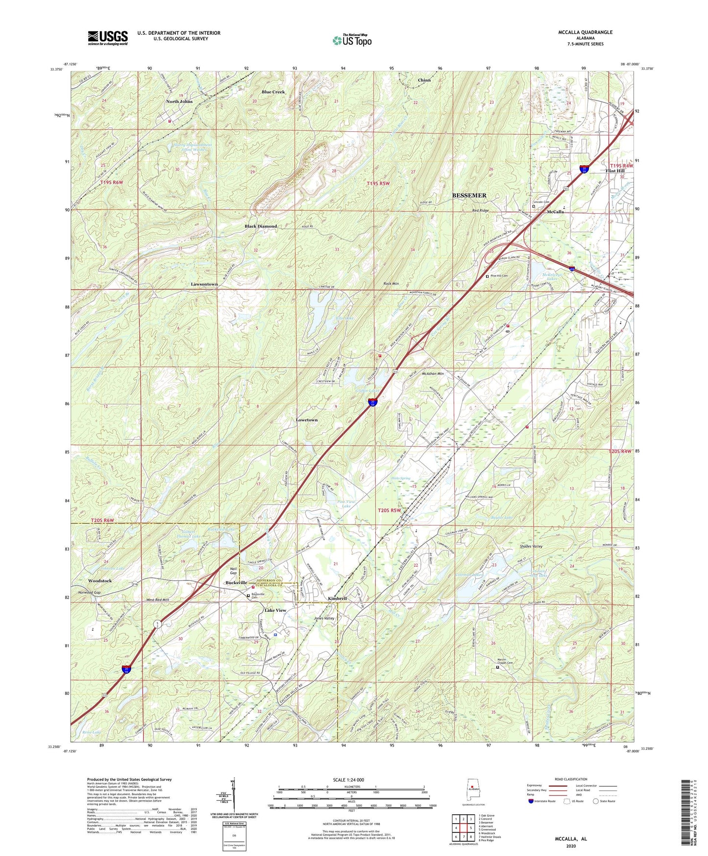
2024 topographic map quadrangle McCalla in the state of Alabama. Scale: 1:24000. Based on the newly updated USGS 7.5' US Topo map series, this map is in the following counties: Jefferson, Tuscaloosa. The map contains contour data, water features, and other items you are used to seeing on USGS maps, but also has updated roads and other features. This is the next generation of topographic maps. Printed on high-quality waterproof paper with UV fade-resistant inks.
Quads adjacent to this one:
West: Abernant
Northwest: Oak Grove
North: Concord
Northeast: Bessemer
East: Greenwood
Southeast: Pea Ridge
South: Halfmile Shoals
Southwest: Woodstock
This map covers the same area as the classic USGS quad with code o33087c1.
Contains the following named places: Antioch Baptist Church, Baylor, Baylor Lake, Baylor Lake Dam, Bellview Church, Big Griffin Lake, Black Diamond, Black Diamond Lake Dam, Blue Creek, Blue Creek Lake Dam, Blue Creek Mine, Bucksville, Bucksville Cemetery, Bucksville School, Burnt Bridge Branch, Camp Nawaka, Chinn, Cloester Valley, Coleman Lakes, Coleman Lakes Number 1 Dam, Confederate Hill Estates, Cooley Creek, Cox Spring Branch, Davis, Ellis Lake, Ellis Lake Dam, Faith School, First Baptist Church of Bucksville, Flint Hill, Frawley, Getmore Number 2 Mine, Gilbert Thomas Lake, Gilbert Tommie Lake Dam, Gilbert Tommie Number 2 Dam, Gitmore Mines, Goethite, Green Isle Country Club, Griffin Lakes, Hicks Spring, Indian Gap Lake, Indian Gap Lake Dam, Johns, Johns Elementary School, Johnson Lake, Jones Valley, Kimbrell, Kimbrell Lake Dam, Lake Griffin Dam, Lake View Police Department, Lakeview Fire Department Station 2, Lawsontown, Lick Branch, Lincoln Cemetery, Little Griffin Lake, Lowetown, Marvin Chapel Cemetery, McAdory Elementary School, McAdory Fire and Rescue Station 2, McAdory High School, McAshan Mountain, McCalla, McCalla Area Fire District Station 1, McCalla Area Fire District Station 2, McCalla Baptist Church, McCalla Census Designated Place, McCalla Chapel, McCalla Lake Dam, McCalla Post Office, McCalla Station, McKelveys Lakes, McNaths, Mill Creek, Moore Brook, Nail Gap, Norman Fountain Dam, Norman Fountain Lake, North Johns, North Johns Volunteer Fire and Rescue, Norwood Gap, Old Blue Creek Church, Osways Mine, Pauline Fletcher Camp, Pine Hill Cemetery, Pine View Lake, Red Hill Heights, Red Ridge, Reno Lake, Rock Lakes, Rock Mountain, Rockview Lake, Saint Luke Church, Serene Lake Number 1, Serene Lake Number 1 Dam, Shades Valley, Slurry Impoundment - Johns Washer, Slurry Impoundment - Johns Washer Dam, Suck Branch, Tannehill, Tannehill State Park, Tannehill Valley Estates, Tannehill Valley Lake, Tannehill Valley Lake Dam, Town of North Johns, West Red Mountain, ZIP Code: 35111