MyTopo
Greenwood Alabama US Topo Map
Couldn't load pickup availability
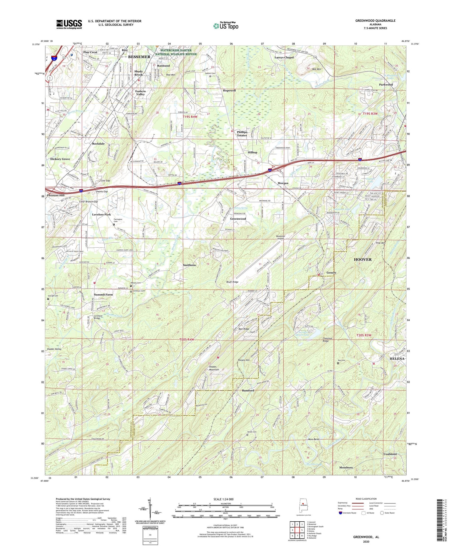
2024 topographic map quadrangle Greenwood in the state of Alabama. Scale: 1:24000. Based on the newly updated USGS 7.5' US Topo map series, this map is in the following counties: Jefferson, Shelby. The map contains contour data, water features, and other items you are used to seeing on USGS maps, but also has updated roads and other features. This is the next generation of topographic maps. Printed on high-quality waterproof paper with UV fade-resistant inks.
Quads adjacent to this one:
West: McCalla
Northwest: Concord
North: Bessemer
Northeast: Birmingham South
East: Helena
Southeast: Alabaster
South: Pea Ridge
Southwest: Halfmile Shoals
This map covers the same area as the classic USGS quad with code o33086c8.
Contains the following named places: Allen Brook, B Mountain Lake, B Mountain Lake Dam, Bamford, Beaverdam Creek, Bee Mountain, Bee Ridge, Bessemer Airport, Bessemer Fire Department Station 3, Bessemer Fire Department Station 4, Bessemer Municipal Golf Course, Bessemer Quarry, Bessemer State Technical College, Birons Ford, Bluff Ridge, Bluff Ridge Church, Bob George Branch, Brocks, Canaan Church, Cherokee Beach, Cherokee Beach Lake, Cherokee Beach Lake Dam, Chestnut Glen, Chestnut Ridge, City of Bessemer, City of Helena, Clear Branch, Clear Branch Gap, Coalmont, Coalmont Mine, Cow Gap, Dickey Spring, Eastern Valley, Eastern Valley Volunteer Fire Department, Eden Ridge, Edgewood, Fairington Cemetery, Fox Trace, Genery, George Cemetery, Greenwood, Greenwood Division, Greenwood Elementary School, Greenwood Junior High School, Guytons Lake, Guytons Lake Dam, Helena Fire Department Station 2, Hickory Grove, High Point, Highlands, Hilltop, Hillview Church, Hoover Fire Department Station 6, Hopewell, Hopewell Church, Hopewell Elementary School, Indian Ford Fire District, Janeway Mine, Jess Lanier High School, Johnsons Lake, Johnsons Lake Dam, Laceys Chapel, Laceys Chapel Elementary School, Little Shades Creek, Lovelace Bridge, Loveless Park, Macedonia Church, Massey Cemetery, McAdory Fire Department, Mobile Junction, Morgan, Morgan Church, Morgan School, Morning Star Church, Moss Bend, Mossboro, Mossboro Branch, Mossburg Number 1 Mine, Owens Gap, Parkwood, Parkwood Church, Parkwood Hills, Phillips Estates, Pine Crest, Pleasant Hill, Pleasant Hill United Methodist Church, Potato Hill, Potter Mine, Raimund, Raimund Elementary School, Ray Cemetery, Rice, Rice Creek, Rockdale, Rocky Brook, Russet Woods, Sadlers Cemetery, Sargon, Shades Mountain, Shades Run, Shades Valley Elementary School, Shady Brook, Shady Grove Church, Shadywood, Shiloh Cemetery, Shiloh Church, Smithson, Smithson Cemetery, Southpointe, Sparks Gap, Summit Farm, Trigger Creek, Twin Lakes Country Club, UAB Health System Medical West Hospital, Weeping Oaks, Wellington Industrial Park, Whispering Oaks, ZIP Codes: 35022, 35080