
MyTopo
Gadsden East Alabama US Topo Map
Couldn't load pickup availability
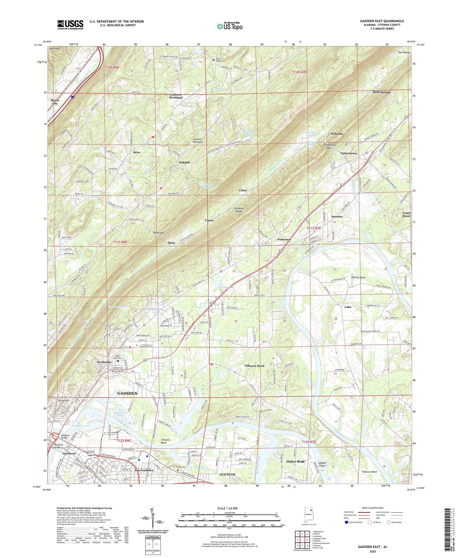
2024 topographic map quadrangle Gadsden East in the state of Alabama. Scale: 1:24000. Based on the newly updated USGS 7.5' US Topo map series, this map is in the following counties: Etowah. The map contains contour data, water features, and other items you are used to seeing on USGS maps, but also has updated roads and other features. This is the next generation of topographic maps. Printed on high-quality waterproof paper with UV fade-resistant inks.
Quads adjacent to this one:
West: Gadsden West
Northwest: Rodentown
North: Keener
Northeast: Leesburg
East: Ballplay
Southeast: Colvin Gap
South: Glencoe
Southwest: Dunaway Mountain
This map covers the same area as the classic USGS quad with code o34085a8.
Contains the following named places: Alfords Bend, Anderson, Ann Cathey Elementary School, Ash Disposal Pond, Ash Disposal Pond Dam, Bath Springs, Beth Israel Cemetery, Boy Scouts Spring, Brice, Brice School, Caddell Island, Caddels Ford, Calvary Baptist Church, Camp Sequoyah Dam, Camp Sequoyah Lake, Carnes Baptist Church, Chappell Spring, Citico, Coal Creek, Coosa Christian Academy, Cory Middle School, Cove Creek, Cranford Chapel Church of God, Croft Cemetery, Daisy, Daisy Gap, Drake School, East Gadsden, East Gadsden Baptist Church, East Gadsden Church of God, East Gadsden Church of the Nazarene, East Gadsden Community Center, East Gadsden Cumberland Presbyterian Church, East Gadsden United Methodist Church, East Walnut Baptist Church, Eastside Baptist Church, Eastside Presbyterian Church, Ebenezer Baptist Church, Edwardsville, Estess Dam, Estess Lake, Evangel Church, Ewing Hill, Fairview, Fairview Baptist Church, Faith Baptist Church, Fitts Ferry, Full Gospel Tabernacle, Gadsden Baptist Temple, Gadsden Center University of Alabama, Gadsden Fire Department Station 6, Gadsden Regional Medical Center, Gadsden State Technical Institute, Gadsden Steam Plant, Gaston High School, Goldenrod Avenue Baptist Church, Goodyear, Goodyear Dam, Goodyear Lake, Gospel Temple, Happy Hill Hog Farm, Hardin Dam, HealthSouth Rehabilitation Hospital of Gadsden, Highland School, Highland Volunteer Fire Department, Hooks Lake, Hooks Lake Spring, J L Wagner Elementary School, James Memorial Baptist Church, Kay Ferry, Laffertys Landing, Lake Mary Louise, Liberty Methodist Church, Litchfield High School, Lookout Mountain Census Designated Place, Lookout Mountain Freewill Baptist Church, Lookout Mountain Volunteer Fire Department, Luke, Meighan Bridge, Memorial Bridge, Miracle Temple Church, Mount Eba Lake, Mount Lookout Congregational Methodist Church, Mount Pisgah Baptist Church Cemetery, Mount Pisgah Missionary Baptist Church, Mount Sinai Spiritual Church, Noojinsville, North Gadsden Baptist Church, North Gadsden Freewill Baptist Church, North Gadsden Park, North Gadsden United Methodist Church, North Highland Baptist Church, Northside, Oakdale, Oakdale School, Oscar W Adams Elementary School, Pascal Church, Pleasant Hill Methodist Church, Shiloh Baptist Church, Sonoma, Thompson Elementary School, Tidmore Bend Census Designated Place, Tidmore Bend Volunteer Fire Department, Tillison Cemetery, Tillisons Bend, Town Creek, Trinity Freewill Baptist Church, Turkeytown, Turkeytown Creek, Turkeytown Gap, Turkeytown Methodist Church, Union Hill Methodist Church, Union Tabernacle, Upton, Victory Missionary Baptist Church, Vocational School, Walkers Landing, Whites Chapel, Whites Chapel Baptist Church, Wilsonia, Wilsons, Wisdom Ferry, Woodland Church, ZIP Codes: 35901, 35904


