MyTopo
Rodentown Alabama US Topo Map
Couldn't load pickup availability
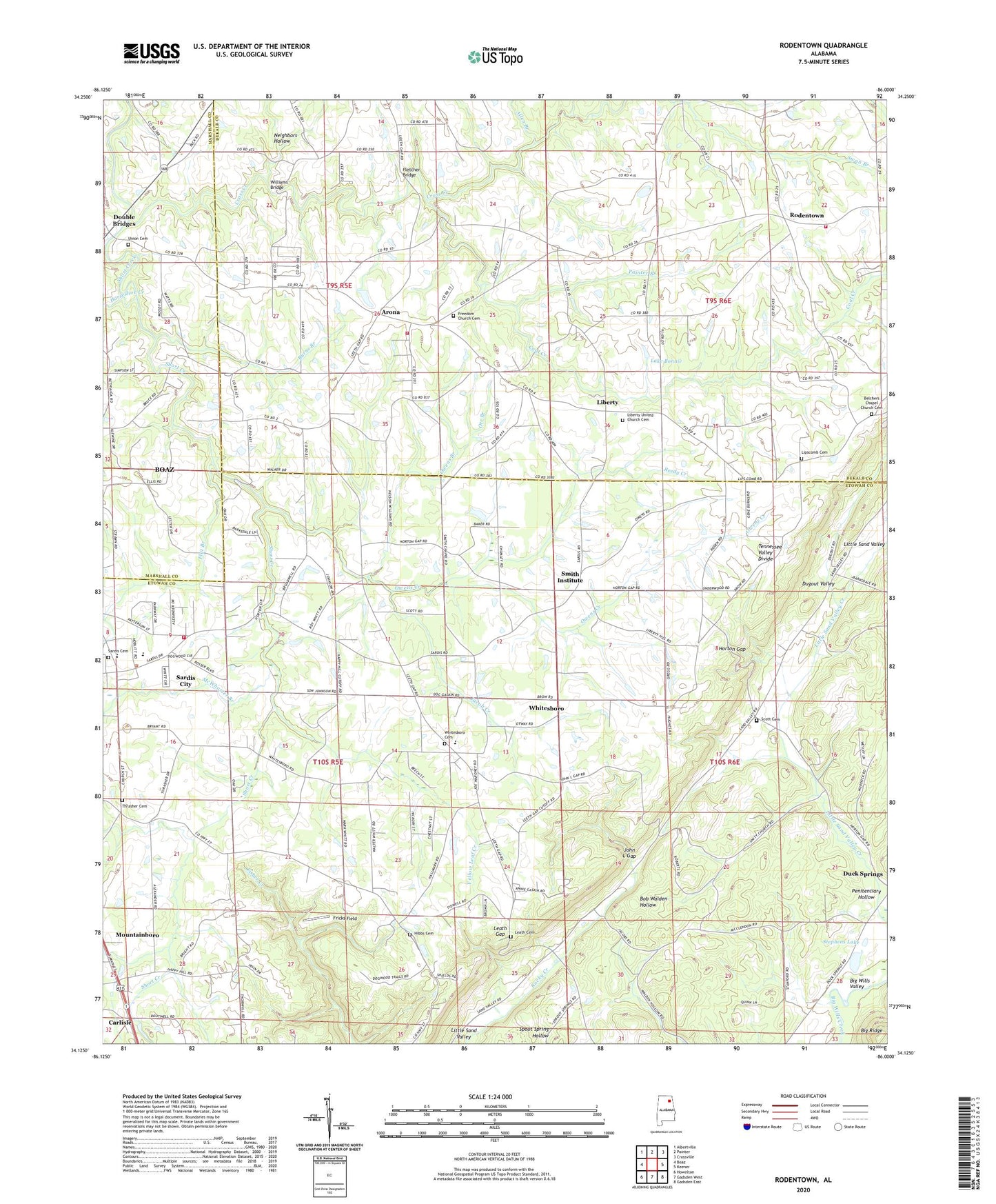
2024 topographic map quadrangle Rodentown in the state of Alabama. Scale: 1:24000. Based on the newly updated USGS 7.5' US Topo map series, this map is in the following counties: Etowah, DeKalb, Marshall. The map contains contour data, water features, and other items you are used to seeing on USGS maps, but also has updated roads and other features. This is the next generation of topographic maps. Printed on high-quality waterproof paper with UV fade-resistant inks.
Quads adjacent to this one:
West: Boaz
Northwest: Albertville
North: Painter
Northeast: Crossville
East: Keener
Southeast: Gadsden East
South: Gadsden West
Southwest: Howelton
This map covers the same area as the classic USGS quad with code o34086b1.
Contains the following named places: Allen Branch, Arona, Aroney Fire Department Station 1, Aroney Fire Department Station 2, Belcher Chapel, Belcher Gap, Belchers Chapel Church Cemetery, Belchers Gap Church, Belview Heights Missionary Baptist Church, Bethlehem Baptist Church, Burns Branch, Burns Mill, Carlisle, Carlisle Missionary Baptist Church, Center Point Junior High School, Coal Creek, Cobbs Mill, Corinth Church, Cross Creek, Double Bridges, Duck Springs School, Dugout Valley, Fenton, Fenton Post Office, Flat Branch, Fletcher Bridge, Freedom Church Cemetery, Fricks Field, Halford School, Happy Hill, Happy Hill Missionary Baptist Church, Happy Hill School, Haworth, Hibbs Cemetery, Horseshoe Creek, Horton Gap, Jacob Creek, Jesus Army Church, John L Gap, Kyuka, Kyuka Baptist Church, Kyuka Baptist Church Cemetery, Kyuka School, Lake Bonnie, Leath Cemetery, Leath Gap, Leath Gap School, Liberty, Liberty Church, Liberty Hill, Liberty Hill Baptist Church, Lipscomb Cemetery, Malferd School, McPherson School, McWhorter Branch, Midway, Mount Flat Church, Mount Zion, Mount Zion Church, Mount Zion School, Mountainboro Division, Neighbors Hollow, Orr Branch, Owens Branch, Owens Creek, Painter Branch, Penitentiary Hollow, Pulltight, Reedy Creek, Rodentown, Rollins, Royse, Royse Post Office, Sardis Baptist Church, Sardis Cemetery, Sardis City, Sardis City Volunteer Fire Department, Sardis High School, Smith Chapel, Smith Institute, Smiths Chapel, Stephens Dam, Stephens Lake, Thrasher Cemetery, Thrashers Crossroads, Town of Sardis City, Union Cemetery, Union Church, Union School, Unity Baptist Church, Webb School, Whitesboro, Whitesboro Baptist Church, Whitesboro Baptist Church Cemetery, Whitesboro Census Designated Place, Whitesboro Elementary School, Williams Bridge, Wills Valley Division, Yellow Leaf Creek