
MyTopo
Hollingers Island Alabama US Topo Map
Couldn't load pickup availability
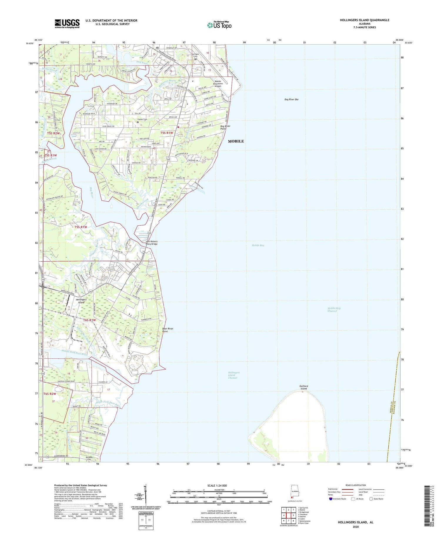
2024 topographic map quadrangle Hollingers Island in the state of Alabama. Scale: 1:24000. Based on the newly updated USGS 7.5' US Topo map series, this map is in the following counties: Mobile, Baldwin. The map contains contour data, water features, and other items you are used to seeing on USGS maps, but also has updated roads and other features. This is the next generation of topographic maps. Printed on high-quality waterproof paper with UV fade-resistant inks.
Quads adjacent to this one:
West: Theodore
Northwest: Spring Hill
North: Mobile
Northeast: Bridgehead
East: Daphne
Southeast: Point Clear
South: Bellefontaine
Southwest: Coden
This map covers the same area as the classic USGS quad with code o30088e1.
Contains the following named places: Alba Club, Alligator Bayou, B C Rains High School, Baker Sorrell Commercial Park, Bayside Post Office, Beachcomber Marina, Berean Baptist Church, Bethel Assembly of God Church, Blue Jay Marina, Brills Trailer Court, Buccaneer Yacht Club, Casher Cemetery, Cedar Park Baptist Church, Cedar Point Road Shopping Center, Christian Life Church, Church of God, Clarke Gardens, Cooper Mobile Home Park, Curve Mobile Home Park, Dauphin Island Parkway Shopping Center, Deer River, Deer River Point, Dog River, Dog River Bar, Dog River Marina, Dog River Point, Gaillard Island, Glory Land Christian Church, Grand View Park, Grant Plaza Shopping Center, Gulf Dale, Gulf Dale Shopping Center, Gulf Fishing and Hunting Club, Hollingers Island, Hollingers Island Channel, Hollingers Island Church, Hollingers Island Elementary School, Hurricane Bay Business Park, John Roberts Peavy Bridge, K and B Village Shopping Center, Lartigue Cemetery, Log Cabin Trailer Court, McNally Community Center, McNally Park, Michele Estates, Middle Fork Deer River, Mobile Fire Rescue Department Petrey Fire Station, Mobile Mennonite Church, Mobile Yacht Club, Moore Creek, Naval Station Mobile, Nazarene Church, New Hope Baptist Church, Newhouse Park, North Fork Deer River, Our Lady of Lourdes Catholic Church, Our Lady of Lourdes School, Parkway Assembly of God Church, Parkway Presbyterian Church, Parkway Southern Baptist Church, Perch Creek, Rabbit Creek, Racetrack School, Riverchase Mobile Home Park, Riverside Baptist Church, Riverside Church of the Nazarene, Robinson Bayou, Saint Andrews Episcopal Church, Saint Philips Church, Sea Pines Mobile Home Park, Sherwood, South Brookley Elementary School, South Brookley United Methodist Church, South Fork Deer River, South Side Church of Christ, Southern Marina and Harbor, The Rock of Mobile Church, Theodore Division, Theodore Industrial Park, Theodore Ship Channel, Trimmer Park, Way of Life Community Church, ZIP Code: 36605


